Unmanned aerial vehicle oblique photographing infrared three-dimensional imaging system and modeling method thereof

A technology of oblique photography and three-dimensional imaging, applied in the field of surveying and mapping, which can solve the problems of inability to detect, inability to analyze the target to be measured, and difficult to find the target, etc.

Active Publication Date: 2015-04-08
INST OF REMOTE SENSING & DIGITAL EARTH CHINESE ACADEMY OF SCI
View PDF13 Cites 23 Cited by
  • Summary
  • Abstract
  • Description
  • Claims
  • Application Information

AI Technical Summary

Problems solved by technology

However, based on this imaging technology, it is impossible to make accurate predictions on the temperature changes of objects, the detection of fire sources, the detection and tracking of suspicious targets, etc.; it is not easy to find in scenarios such as animal migration monitoring at night, personnel search and rescue during earthquakes, and night investigations. Targets cannot be detected at night, etc. In the above scenarios, the technology of tracking visible light cannot enable technicians to analyze the target according to the image

Method used


Image

  • Unmanned aerial vehicle oblique photographing infrared three-dimensional imaging system and modeling method thereof
  • Unmanned aerial vehicle oblique photographing infrared three-dimensional imaging system and modeling method thereof
  • Unmanned aerial vehicle oblique photographing infrared three-dimensional imaging system and modeling method thereof

Examples


Embodiment Construction

[0034] The specific embodiments of the invention will be further described below in conjunction with the accompanying drawings. The following examples are only used to illustrate the technical solution of the present invention more clearly, but not to limit the protection scope of the present invention.

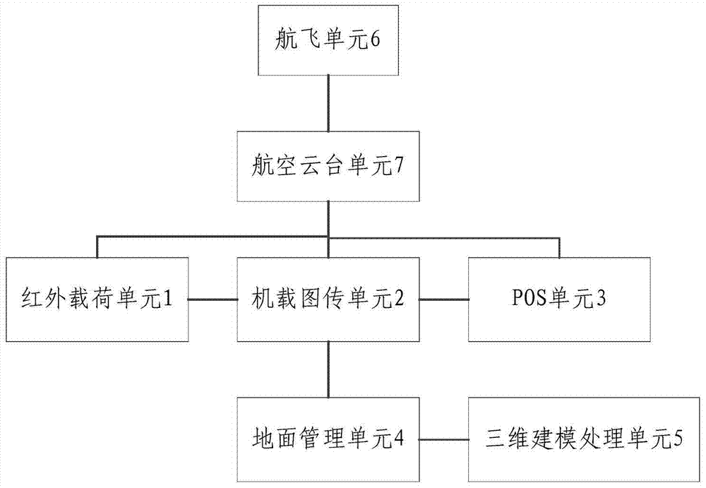
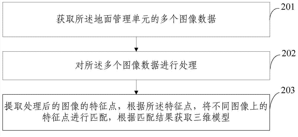
[0035] figure 1 It shows a UAV oblique photography infrared three-dimensional imaging system provided by the embodiment of the present invention, including: infrared load unit 1, airborne image transmission unit 2, POS unit 3, ground management unit 4 and three-dimensional modeling processing unit 5 ;

[0036] Both the infrared load unit and the POS unit are connected to the airborne image transmission unit, the airborne image transmission unit is connected to the ground management unit, and the ground management unit is connected to the three-dimensional modeling processing unit ;

[0037] The infrared load unit is used to image ground objects and send the images to the a...


PUM


Abstract

The invention discloses an unmanned aerial vehicle oblique photographing infrared three-dimensional imaging system and a modeling method thereof. The system comprises an infrared loading unit, a vehicle-mounted image transmission unit, a POS unit, a ground management unit and a three-dimensional modeling processing unit. The infrared loading unit is used for imaging of a ground object and transmitting an image to the vehicle-mounted image transmission unit; the POS unit is used for measuring position and attitude information of the system; the vehicle-mounted image transmission unit is used for receiving the image transmitted by the infrared loading unit and the position and attitude information measured by the POS unit and transmitting the image and the position and attitude information to the ground management unit; and the three-dimensional modeling processing unit is used for establishing a three-dimensional model according to the image and the position and attitude information of the POS system which are received by the ground management unit. According to the system, infrared image of the object to be measured is acquired and three-dimensional modeling is performed on the image so that accurate positioning and scientific decision making can be performed by technical personnel according to the three-dimensional model.

Description

technical field [0001] The invention relates to the technical field of surveying and mapping, in particular to an infrared three-dimensional imaging system and a modeling method for oblique photography of an unmanned aerial vehicle. Background technique [0002] Tilt photography technology is a high-tech developed in the field of international surveying and mapping in recent years. Different from vertical angle shooting in the past, tilt photography is equipped with multiple sensors on the same aviation platform, and collects images from one vertical and four oblique angles at the same time. Through 3D modeling technology, multi-angle oblique images and vertical images are constructed into a 3D model of ground objects and scenes, which introduces users to intuitive and real scenes that conform to human vision. [0003] At present, most of them use visible light cameras for imaging, and analyze the imaging results to obtain 3D models. However, based on this imaging technolog...

Claims


Application Information

Patent Timeline
IPC IPC(8): G06T17/00G06T5/00
CPCG01C11/02G06T5/40G06T17/00
Inventor 张红明吴太夏张立福张鹏童庆禧
Owner INST OF REMOTE SENSING & DIGITAL EARTH CHINESE ACADEMY OF SCI
Why Eureka
Try Eureka