
Underwater magnetic field and six-axis inertia combined positioning system

A joint positioning, six-axis technology, applied in measurement devices, instruments, mapping and navigation, etc., can solve the problems of large drift, high cost, low accuracy, etc., to filter out interference, ensure stability and accuracy, and reduce system costs. Effect

Inactive Publication Date: 2015-04-15
NANJING ZHUANCHUANG INTPROP SERVICES
View PDF0 Cites 6 Cited by
  • Summary
  • Abstract
  • Description
  • Claims
  • Application Information

AI Technical Summary

Problems solved by technology

In the military field, it is expensive to use terrain matching and other means; in the civilian field, due to cost constraints, the sole use of strapdown inertial and gyroscope guidance has disadvantages such as low accuracy and large drift, and can only be used as a short-term rough positioning

Method used


Image

  • Underwater magnetic field and six-axis inertia combined positioning system
  • Underwater magnetic field and six-axis inertia combined positioning system
  • Underwater magnetic field and six-axis inertia combined positioning system

Examples


Embodiment Construction

[0011] Below in conjunction with accompanying drawing and specific embodiment the present invention is described in further detail:

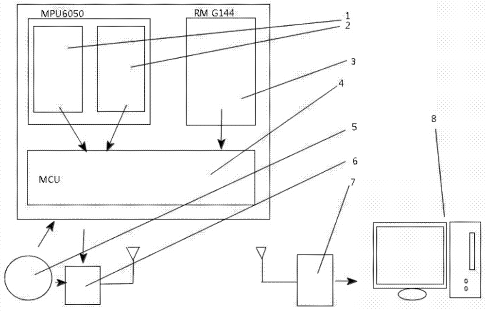
[0012] Such as figure 1 As shown, 1 and 2 are the sensing chip MPU6050 composed of a three-axis acceleration sensor and a three-axis gyroscope respectively, and 3 is a three-axis magnetometer RM G144. These two sensing chips will sense the The acceleration, acceleration and magnetic field strength of each axis of the sensor are sent to the main processor 4.

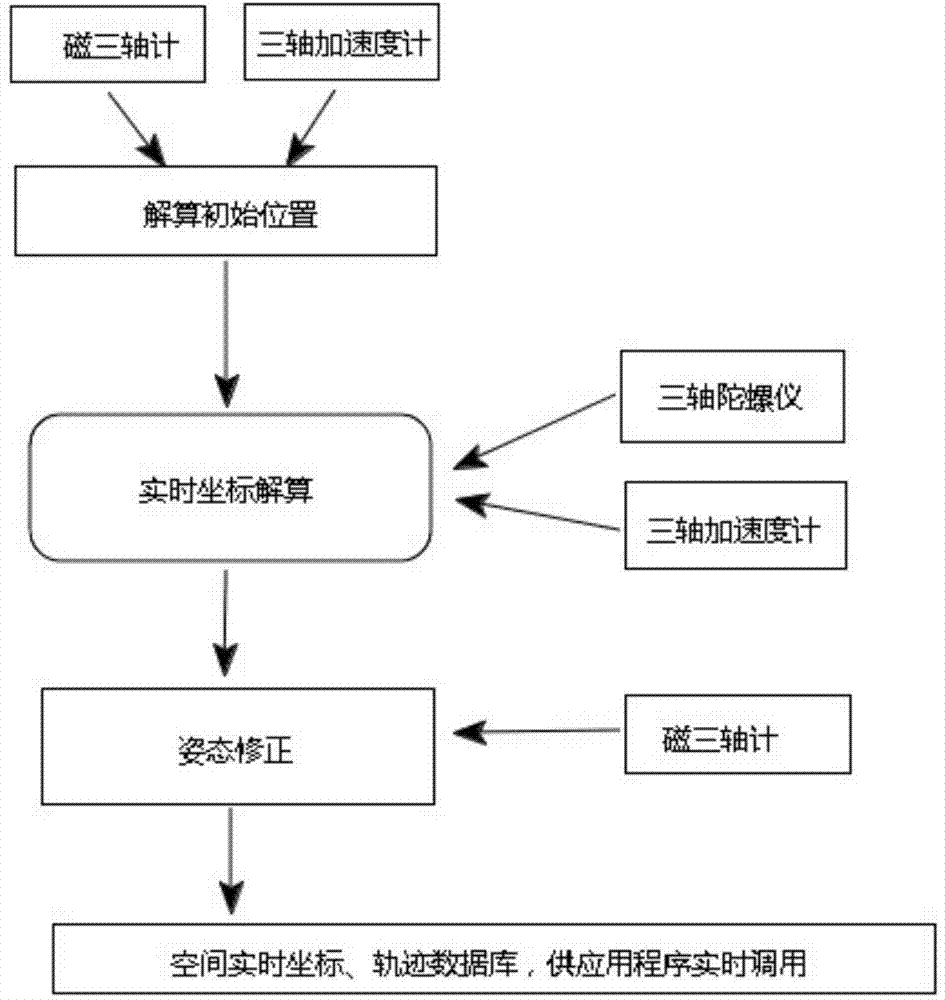
[0013] Such as figure 2 Shown are the steps required for the computer system 8 to perform underwater space calculations. First determine the absolute underwater space coordinate system. First, after starting up, 8 determines the acceleration value of each axis when the angular velocity is 0 in the initial state, and determines the acceleration force value and direction of the three axes. Determine the magnetic field strength values ​​of the three axes at this time, and calculate their ...


PUM


Abstract

The invention relates to an underwater magnetic field and six-axis inertia combined positioning system. The system includes the following parts: (1) and (2) are respectively a sensing chip MPU6050 composed of a three-axis acceleration sensor and a triaxial gyroscope, (3) is a triaxial magnetometer RMG144, the two sensing chips send sensed each axis acceleration, acceleration and magnetic field intensity to a host processor (4) through an I2C bus, the host processor (4) finishes preliminary calculation of attitude and determines an absolute underwater space coordinate system, then attitude calculus and action signal discrimination are completed, the absolute position of the current underwater space and the button, function and the like needing control are output to a wireless transmission module (6), a power module (5) is responsible for power supply of the whole system, a receiving module (7) is responsible for receiving and decoding previous data and converts the data into a computer identifiable signal, and a computer (8) subjects the received data to processing and modeling, thus finishing the task of establishing an underwater space trajectory description system.

Description

technical field [0001] The present invention The present invention relates to an underwater positioning system, in particular to an underwater magnetic field and six-axis inertial joint positioning system. Background technique [0002] The problem of underwater positioning has always been a difficult problem that plagues various underwater operations. In the military field, it is expensive to use terrain matching and other means; in the civilian field, due to cost constraints, the sole use of strapdown inertial and gyroscope guidance has disadvantages such as low accuracy and large drift, and can only be used as a short-term rough positioning . The invention relates to an underwater magnetic field and six-axis inertial joint positioning system. According to the change characteristics of the underwater magnetic field, it can perform perturbation correction on the strapdown inertial and gyroscope-guided system in real time, ensuring the stability and accuracy of the system. ...

Claims


Application Information

Patent Timeline
Patent Type & Authority Applications(China)
IPC IPC(8): G01C21/16
CPCG01C21/165
Inventor 娄保东
Owner NANJING ZHUANCHUANG INTPROP SERVICES
Learn More