GIS (Geographic Information System)-based urban hydrological run-off calculating method and system

A technology for urban hydrology and water flow direction, applied in computing, instrumentation, electrical and digital data processing, etc., can solve problems such as inaccurate hydrological runoff calculation, and achieve the effect of increasing differences and accurate calculation

Inactive Publication Date: 2015-07-01
GUANGDONG URBAN & RURAL PLANNING & DESIGN INST
View PDF4 Cites 6 Cited by
  • Summary
  • Abstract
  • Description
  • Claims
  • Application Information

AI Technical Summary

Problems solved by technology

[0004] This application provides a GIS-based urban hydrological runoff calculation method and system to solve the problem of inaccurate calculation of hydrological runoff in the prior art

Method used


Image

  • GIS (Geographic Information System)-based urban hydrological run-off calculating method and system
  • GIS (Geographic Information System)-based urban hydrological run-off calculating method and system
  • GIS (Geographic Information System)-based urban hydrological run-off calculating method and system

Examples


Embodiment 1

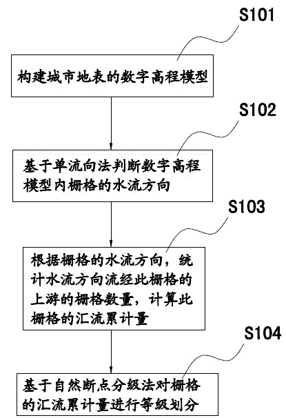
[0026] A GIS-based urban hydrological runoff calculation method, such as figure 1 shown, including the following steps:

[0027] S101: constructing a digital elevation model of the urban surface;

[0028] S102: Judging the water flow direction of the grid in the digital elevation model based on the single flow method;

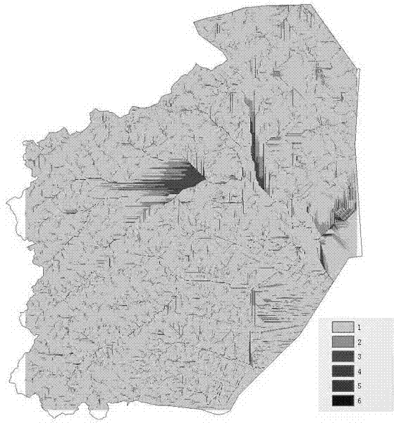
[0029] S103: According to the water flow direction of the grid, count the number of grids upstream of the grid in the water flow direction, and calculate the cumulative flow of the grid;

[0030] S104: Classify the accumulated flow of the grid based on the natural break point classification method.

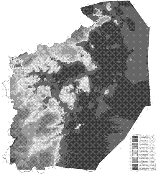
[0031] Such as figure 2 As shown, the digital elevation model belongs to a raster image of a continuous surface. It is a spatial data model that describes the morphological characteristics of the surface undulation. By combining geographic information data and remote sensing images, vectorized processing is performed to construct a digital elevation model. Th...

Embodiment 2

[0035] Such as Figure 4 As shown, this embodiment includes the following steps:

[0036] S201: Construct a digital elevation model of the urban surface;

[0037] S202: Judging the water flow direction of the grid in the digital elevation model based on the single flow method;

[0038] S203: According to the water flow direction of the grid, count the number of grids upstream of the grid in the water flow direction, and calculate the cumulative flow of the grid.

[0039] S204: Classify the accumulated flow of the grid based on the natural breakpoint classification method;

[0040] S205: Determine the vulnerability level of the grid according to the preset land use attributes;

[0041] S206: Superimposing and multiplying the level value of the cumulative amount of confluence of the grid and the value of the vulnerability level, and displaying the grid as a corresponding color according to the obtained product value.

[0042] As an improvement of Example 1, such as Figure ...

Embodiment 3

[0049] A GIS-based urban hydrological runoff calculation system, including:

[0050] A modeling unit for constructing a digital elevation model of the urban surface;

[0051] A judging unit, configured to judge the water flow direction of the grid in the digital elevation model based on the single-flow method;

[0052] The calculation unit is used to count the number of grids upstream of the grid in the direction of water flow according to the water flow direction of the grid, and calculate the cumulative flow of the grid;

[0053] The catchment unit is used to classify the catchment cumulative amount of the raster based on the natural break point classification method.


PUM


Abstract

The invention discloses a GIS (Geographic Information System)-based urban hydrological run-off calculating method. The method comprises the following steps of building a urban surface digital elevation model; judging the water direction of a grid in the digital elevation model based on a single flow direction algorithm; carrying out statistics on the number of grids which flow through the upstream of the grid in the current direction, and calculating the converging cumulant of the grid; and grading the converging cumulant of the grid based on natural breaks grading. Meanwhile, the invention further discloses a GIS-based urban hydrological run-off calculating system. The system comprises a modeling unit, a judgment unit, a calculating unit and a converging unit. According to the calculating method and the calculating system provided by the invention, the hydrological run-off can be accurate to be calculated and more reasonable to be planed, thereby being convenient for subsequent urban planning.

Description

technical field [0001] This application relates to the field of graphic processing, in particular to a method and system for calculating urban hydrological runoff based on GIS. Background technique [0002] Urbanization is the inevitable result of the development and progress of human society. Since the beginning of the 21st century, China's urbanization has grown rapidly. In the economic-centered and GDP-oriented urban development model, cities have expanded in a way that spreads the pie. With this development, there are more and more problems in urbanization, and urban security is facing severe challenges. In addition, under the influence of more frequent extreme rainstorms due to global climate change in recent years, how to take into account urban rain and flood safety in urban planning has become a major problem. . At present, the solution to the problem of rain and flood safety is mostly one-sided, and engineering measures are used for application. Flood protection di...

Claims


Application Information

Patent Timeline
Patent Type & Authority Applications(China)
IPC IPC(8): G06F17/50
Inventor 黄冕眉凌霄阮浩德刘青陈满熊晓冬陈静黄卓
Owner GUANGDONG URBAN & RURAL PLANNING & DESIGN INST
Why Eureka
Try Eureka