Beidou foundation navigation network ground monitoring station and satellite capturing and tracing method of receiver thereof

A technology of ground monitoring stations and Beidou satellites, applied in satellite radio beacon positioning systems, measurement devices, radio wave measurement systems, etc., can solve problems such as poor timeliness, difficulty in capturing and tracking, and discontinuity, and achieve the goal of improving performance Effect

Active Publication Date: 2015-07-29
CHENGDU CORPRO TECH CO LTD
View PDF2 Cites 11 Cited by
  • Summary
  • Abstract
  • Description
  • Claims
  • Application Information

AI Technical Summary

Problems solved by technology

Because the pulsed pseudolite signal is output in bursts and is discontinuous, it has certain uncertainty for the monitoring receiver, so it is very difficult for the monitoring receive

Method used


Image

  • Beidou foundation navigation network ground monitoring station and satellite capturing and tracing method of receiver thereof
  • Beidou foundation navigation network ground monitoring station and satellite capturing and tracing method of receiver thereof
  • Beidou foundation navigation network ground monitoring station and satellite capturing and tracing method of receiver thereof

Examples


Embodiment Construction

[0048] The technical solution of the present invention will be further described in detail below in conjunction with the accompanying drawings, but the protection scope of the present invention is not limited to the following description.

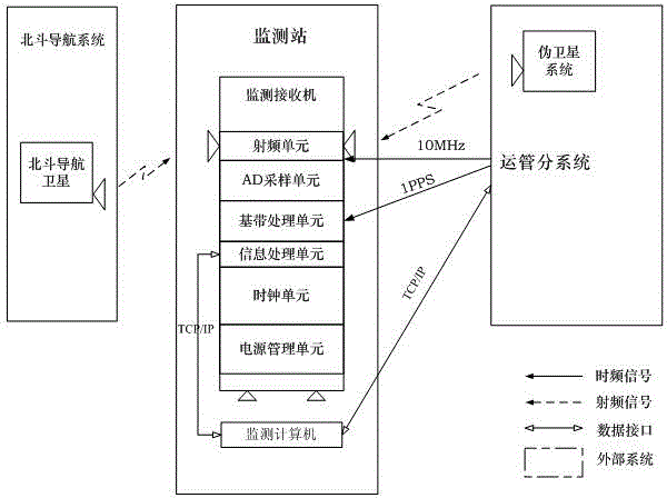
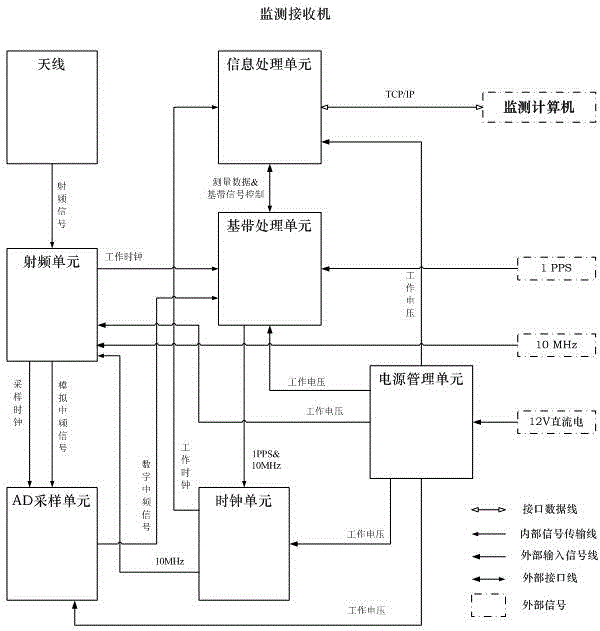
[0049] Such as figure 1 As shown, the Beidou ground-based navigation network ground monitoring station is used to complete the status monitoring of the Beidou ground-based navigation network pseudolite, use the pseudolite for independent positioning or use the pseudolite and Beidou satellite for coordinated positioning, and calculate the positioning error based on the position of the known monitoring station , and feed back the positioning error and all original data to the transportation management subsystem, and then the transportation management subsystem calculates the data reported by multiple monitoring stations to obtain the time difference between the pseudolites and between the pseudolites and the Beidou system. The pseudolite syst...


PUM


Abstract

The invention discloses a Beidou foundation navigation network ground monitoring station and a satellite capturing and tracing method of a receiver thereof. The monitoring receiver comprises a radio frequency unit, an AD sampling unit, a baseband processing unit, an information processing unit, a clock unit and a power supply management unit. The invention provides the Beidou foundation navigation network ground monitoring station and the satellite capturing and tracing method of the receiver thereof, wherein the monitoring receiver can quickly and accurately capture pseudolite signals and quickly parse out complete frame data, positioning is performed by pseudolites or a pseudolite and a Beidou satellite, positioning errors are computed according to the known monitoring station position, the positioning errors and all original data are fed back to an operation management sub-system, then the operation management sub-system computes according to data reported by the plurality of monitoring stations to obtain the time difference between the pseudolites or between pseudolites and Beidou satellites, the time of the pseudolite system is corrected, and thereby the performance of the foundation pseudolite enhanced system is promoted.

Description

technical field [0001] The invention relates to a Beidou ground-based navigation network ground monitoring station and a satellite capturing and tracking method for its receiver. Background technique [0002] China's BeiDou Navigation Satellite System (BDS) is a global satellite navigation system developed by China itself. It is the third mature satellite navigation system after the US Global Positioning System (GPS) and Russia's GLONASS satellite navigation system. Beidou Satellite Navigation System (BDS), GPS of the United States, GLONASS of Russia, and GALILEO of the European Union are certified suppliers by the United Nations Satellite Navigation Commission. The Beidou satellite navigation system consists of three parts: the space segment, the ground segment and the user segment. It can provide high-precision, high-reliability positioning, navigation, and timing services for all types of users around the world, all-weather, and has short-message communication. It has i...

Claims


Application Information

Patent Timeline
IPC IPC(8): G01S19/11G01S19/23G01S19/25
CPCG01S19/11G01S19/23G01S19/25
Inventor 柏杰明元刘佳
Owner CHENGDU CORPRO TECH CO LTD
Why Eureka
Try Eureka