Time slot optimization-based double-layer satellite network routing method

A double-layer satellite network and satellite technology, which is applied in the field of satellite communication, can solve the problems of GEO satellites establishing connections, not considering polar-orbiting satellites, and high routing protocol overhead, so as to reduce connection and inter-layer communication overhead, and reduce protocol overhead , the effect of reducing the number

Active Publication Date: 2015-08-05
HARBIN INST OF TECH
View PDF5 Cites 48 Cited by
  • Summary
  • Abstract
  • Description
  • Claims
  • Application Information

AI Technical Summary

Problems solved by technology

[0006] The present invention is to solve the problem that the routing protocol overhead of the traditional method is relatively large, it is difficult for LEO satellites to establish a connection with GEO satellites in the polar regions, and the problem of temporary disconnection of the links between the orbits of the polar orbit satellites in the polar regions is not considered, and a time-based Gap-optimized dual-layer satellite network routing method

Method used


Image

  • Time slot optimization-based double-layer satellite network routing method
  • Time slot optimization-based double-layer satellite network routing method
  • Time slot optimization-based double-layer satellite network routing method

Examples


specific Embodiment approach 1

[0029] Specific embodiment one: a kind of double-layer satellite network routing method based on timeslot optimization of the present embodiment, it is realized according to the following steps:

[0030] (1) Constructing a 3GEO+66LEO double-layer satellite network model;

[0031] (2) On the basis of the 3GEO+66LEO double-layer satellite network model, use the satellite grouping management method based on "coverage domain clustering + orbit plane clustering" to determine the control relationship between the upper and lower satellites;

[0032] (3) Divide and optimize the time slots of the satellite operation cycle according to the control relationship between the upper and lower satellites;

[0033] (4) Routing algorithm based on position prediction GEO satellite calculates routing table for LEO satellite;

[0034] (5) In combination with steps (1) to (4), routing update is performed at the beginning of each time slice.

specific Embodiment approach 2

[0035] Specific implementation mode two: the difference between this implementation mode and specific implementation mode one is: step (1) is specifically:

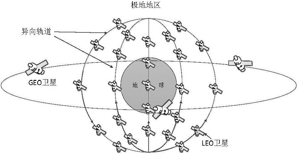
[0036] like figure 1 As shown, 3 GEO satellites and 66 LEO satellites are used to form the system space segment. The system constellation parameters are: the GEO layer orbit height is 35,786 kilometers, the orbit inclination is 0°, the number of orbits is 1, and each GEO satellite has two orbits For the link in the plane, the minimum communication angle is 22°, and the GEO satellites are located at -80°, 40°, and 160° east longitude respectively; the LEO layer orbit height is 780 kilometers, the orbit inclination angle is 86.4°, and the number of orbits is 6. Each LEO The satellite has links within two orbital planes and links between two orbital planes, and the minimum communication angle is 8.2°;

[0037] Among them, in the two-layer satellite network model, LEO satellites support user access and data forwarding, GEO s...

specific Embodiment approach 3

[0040] Specific implementation mode three: the difference between this implementation mode and specific implementation mode one or two is: the first step: the GEO satellite creates a management group, and waits for each cluster head LEO satellite to join the management group;

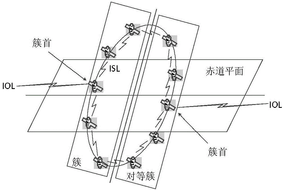
[0041] The second step: the LEO satellites are clustered according to the orbital plane, and the cluster head LEO satellites are determined;

[0042] Wherein, the cluster-head LEO satellite is responsible for the determination of the upper-level managers, the aggregation of link state information in the cluster, and the distribution of the routing table, and contacts the upper-level managers on behalf of the satellites in the cluster; the selection of the LEO satellite cluster and the cluster head is as follows: figure 2 shown;

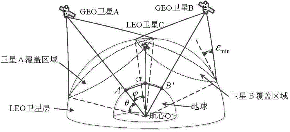
[0043] Step 3: Find all the GEO satellites covering it from the cluster head LEO satellite; if there is only one GEO satellite, use the GEO satellite as the group manager; if ...


PUM


Abstract

The invention relates to a time slot optimization-based double-layer satellite network routing method, so as to solve the problems that routing protocol overhead in the traditional method is large, an LEO satellite is hard to be connected with a GEO satellite in a polar region, and temporary link breaking of a polar orbit satellite between polar region orbits is not considered. The method comprises steps: (1) a 3GEO+66LEO double-layer satellite network model is built; (2) a covering domain grouping + orbit plane clustering-based satellite grouping management method is applied to determine a control relationship between an upper layer of satellites and a lower layer of satellites; (3) according to the control relationship between the upper layer of satellites and the lower layer of satellites, time slot division and optimization are carried out on a satellite operation cycle; (4) on the basis of location prediction routing algorithm, the GEO satellites calculate a routing table for the LEO satellites; and (5) the first step to the fourth step are combined, and routing updating is carried out when each time slice starts. The method belongs to the field of satellite communication.

Description

technical field [0001] The invention relates to a double-layer satellite network routing method based on time slot optimization, which belongs to the field of satellite communication. Background technique [0002] With the rapid development and rapid application of space technology, the strategic position of space in military, political and economic fields is becoming more and more important. Therefore, the development of space information network with satellite system as the core is one of the important tasks for all countries in the world to develop space power. The single-layer satellite network can no longer meet the system design requirements of the space information network, so it is very important to study the hybrid heterogeneous multi-layer satellite network. [0003] Compared with a single-layer satellite network, a multi-layer satellite network has many advantages. The multi-layer satellite network has flexible networking, strong invulnerability, diversified func...

Claims


Application Information

Patent Timeline
Patent Type & Authority Applications(China)
IPC IPC(8): H04B7/185H04L12/715H04L12/755
CPCH04B7/18521H04B7/1856H04L45/021H04L45/04H04L45/46
Inventor 杨明川陈健飞邵欣业唐力群袁莞迈李原冯玺宝陈佳音谭璐田日才唐文彦
Owner HARBIN INST OF TECH
Why Eureka
Try Eureka