
Remote sensing image fusion method based on convolution enhancement and HCS transform

A fusion method and remote sensing image technology, applied in image enhancement, image analysis, image data processing, etc., can solve the problems of limited enhancement of spatial details and insufficient consideration of spatial information

Inactive Publication Date: 2015-08-19
SUN YAT SEN UNIV
View PDF2 Cites 12 Cited by
  • Summary
  • Abstract
  • Description
  • Claims
  • Application Information

AI Technical Summary

Problems solved by technology

However, the current fusion theory based on HCS transformation (such as Mode and Smart Mode), it does not consider enough the spatial information in the image, and its ability to enhance spatial details is limited.

Method used


Image

  • Remote sensing image fusion method based on convolution enhancement and HCS transform
  • Remote sensing image fusion method based on convolution enhancement and HCS transform
  • Remote sensing image fusion method based on convolution enhancement and HCS transform

Examples


Embodiment 1

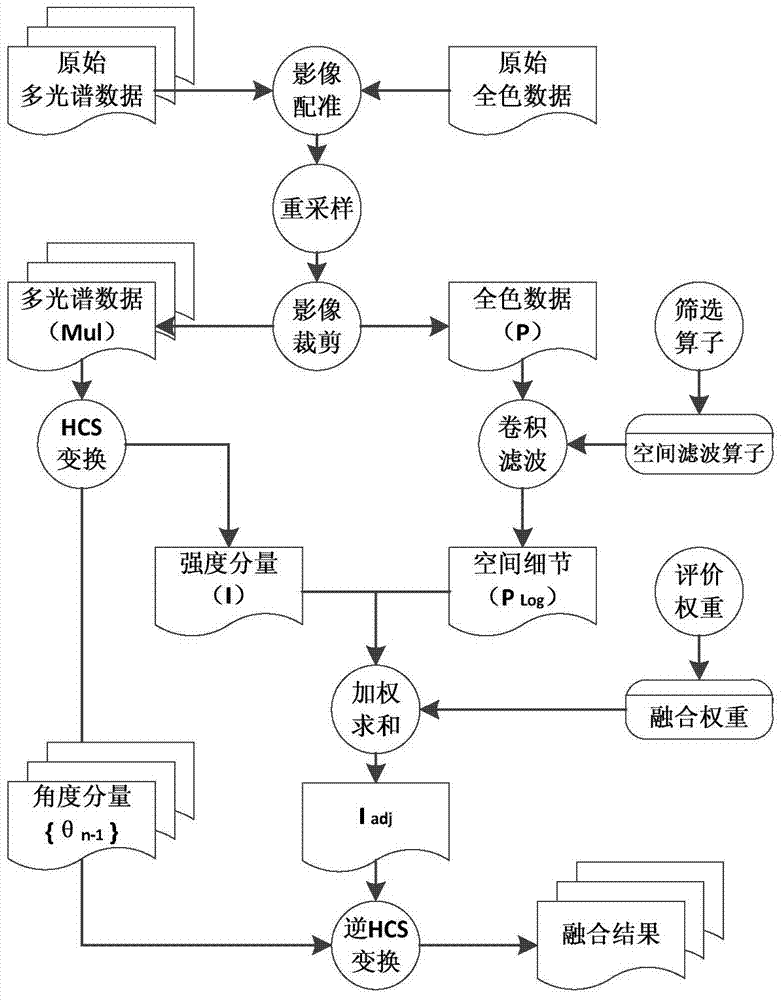
[0033] figure 1 The flow chart of the remote sensing image fusion method based on convolution enhancement and HCS transformation is given, including the following steps:

[0034] Obtain the original multispectral data and the original panchromatic data respectively;

[0035] Perform image registration on the above data;

[0036] Resample the registered data, and then crop the sampled data;

[0037] After image clipping, multispectral data (Mul) and panchromatic data (P) are obtained respectively;

[0038] Perform HSC transformation on multispectral data (Mul) to obtain intensity components and several angle components;

[0039] The spatial detail information is obtained by performing convolution filtering on the panchromatic data (P) with a spatial filter operator, and the spatial filter operator is a spatial filter operator selected according to the filter operator;

[0040] The spatial detail information is added to the intensity component with a certain weight to obtain...


PUM


Abstract

The invention discloses a remote sensing image fusion method based on convolution enhancement and HCS transform. A multi-spectrum image with low spatial resolution and a panchromatic image with high spatial resolution are registered, the multi-spectrum image with low spatial resolution is re-sampled to have the same pixel size as the panchromatic image with high spatial resolution, and cutting is performed to obtain a multi-spectrum image and a panchromatic image with the same sheet range waiting for fusion; HCS transform is performed on the multi-spectrum image with low spatial resolution to obtain a strength component and a plurality of angle components; a spatial filtering operator is adopted to perform convolution filtering on the panchromatic image with high spatial resolution to obtain space details; the space details are compensated into the strength component in weight to obtain an enhanced strength component; and the enhanced strength component is decomposed by the obtained angle components to obtain a final fusion image. According to the method, HCS transform and the convolution filtering algorithm are applied to fusion of the multi-spectrum image and the panchromatic image, and the space details of the fusion result are greatly enhanced.

Description

technical field [0001] The invention belongs to the field of remote sensing image processing data fusion, and relates to a remote sensing image fusion method based on convolution enhancement and HCS transformation, which is a remote sensing image fusion method for spatial detail enhancement by using convolution filtering technical means. technical background [0002] Remote sensing images with both high spatial resolution and multispectral characteristics have basically become high spatial resolution images through image fusion of high spatial resolution single spectral band panchromatic images and low spatial resolution multispectral images. It is a necessary preprocessing link of remote sensing analysis. As far as the methods in this field are concerned, the current image fusion can be divided into pixel-level, feature-level and decision-level fusion; among the three levels, the theoretical basis of pixel-level fusion is the most complete and the most widely used. Typical ...

Claims


Application Information

Patent Timeline
IPC IPC(8): G06T7/00
CPCG06T7/37G06T2207/20221
Inventor 柳林刘洋刘凯李想
Owner SUN YAT SEN UNIV
Learn More