
A 3D Terrain Generation Method with Local Accuracy Constraints

A three-dimensional terrain, precision-constrained technology, applied in the field of three-dimensional visualization, to achieve the effect of large amount of data, avoid complicated judgment, and solve the problem of memory space allocation

Active Publication Date: 2017-11-07
BEIJING INST OF CONTROL ENG
View PDF3 Cites 0 Cited by
  • Summary
  • Abstract
  • Description
  • Claims
  • Application Information

AI Technical Summary

Problems solved by technology

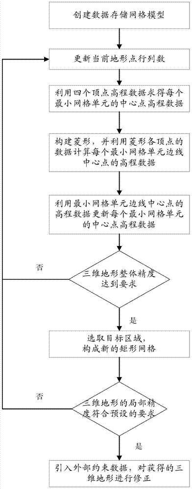
[0004] The technical problem to be solved by the present invention is to provide a three-dimensional terrain generation method for local precision constraints in view of the lack of accuracy of the above-mentioned terrain generation method, and realize constraint control by optimizing the rhombus-square algorithm, so that the generated terrain shape is closer to the natural shape , through local constraints, the introduction of fixed shape data produces highly realistic natural effects, and by extracting the middle part of the grid, the center is constrained, which greatly improves the accuracy of the terrain; the invention generates a large amount of data, and can generate overall high-resolution high-rate data, and meet the local precision requirements; when storing, by using a more complex linked list structure to store data points, the problem of continuous allocation of large areas of physical memory is reduced

Method used


Image

  • A 3D Terrain Generation Method with Local Accuracy Constraints
  • A 3D Terrain Generation Method with Local Accuracy Constraints
  • A 3D Terrain Generation Method with Local Accuracy Constraints

Examples


Embodiment Construction

[0053] The present invention provides a three-dimensional terrain generation method with local precision constraints, and the present invention will be further described below in conjunction with the accompanying drawings.

[0054] For ease of understanding, before introducing the principle of 3D terrain generation, the principle of 2D terrain generation in the rhombus-square algorithm is taken as an example to illustrate. In one-dimensional space, the midpoint displacement is performed as follows:

[0055] (1) Start with a line segment AB, such as figure 2 As shown, for some appropriate dHeight, take the midpoint C of line segment AB and replace it with a random value between -dHeight and +dHeight, as in image 3 As shown, point C is a point newly generated from points A and B after replacement;

[0056] (2) Reduce the value of dHeight and recursively process the line segments AC and CB, such as Figure 4 As shown, points D and E are points newly generated from points A, ...


PUM


Abstract

A three-dimensional terrain generation method with local precision constraints, the method realizes sub-level constraint control by optimizing the rhombus-square algorithm, and makes the generated terrain shape closer to the natural shape. Through local constraints, the introduction of fixed shape data produces highly realistic natural effects, and by extracting the middle part of the grid, the center is constrained, which greatly improves the accuracy of the terrain. The invention generates a large amount of data, can generate overall high-resolution data according to requirements, and satisfies local precision requirements. By using a more complex linked list structure to store data points during storage, the problem of continuous allocation of large areas of physical memory is reduced. The invention solves the shortcomings of the limited overall terrain accuracy and the inability to modify the local terrain accuracy of the three-dimensional terrain generation method, and has broad promotion and application prospects in the development of three-dimensional terrain for visual simulation systems such as rocket launch, lunar surface work, and near-ground work.

Description

technical field [0001] The invention relates to a three-dimensional terrain generation method, in particular to a local precision-constrained three-dimensional terrain generation method, which belongs to the technical field of three-dimensional visualization. Background technique [0002] In today's digitized and informatized world, with the continuous expansion of geographic information applications, traditional two-dimensional maps can no longer meet people's needs, and people are beginning to pay more and more attention to three-dimensional topographic maps with rich topographic and topographical information. However, due to the complex and diverse natural terrain and limited computer processing power, there are problems in this field such as limited precision of visualization processing and lack of realism in 3D display effects. [0003] At present, mature commercial modeling software such as 3D MAX, VUE and VTB are widely used in the field of 3D visualization to realize...

Claims


Application Information

Patent Timeline
Patent Type & Authority Patents(China)
IPC IPC(8): G06T17/05
Inventor 徐希悦贾永唐强张南峰石磊
Owner BEIJING INST OF CONTROL ENG
Learn More