Shot scenery-based navigation method and system thereof

A navigation method and technology for a navigation system, which are applied to a navigation system based on photographed scenes and in the field of navigation based on photographed scenes, can solve problems such as inability to navigate, and achieve the effect of being convenient to carry around.

Inactive Publication Date: 2015-09-09
NAT UNIV OF SINGAPORE SUZHOU RES INST +1
View PDF0 Cites 26 Cited by
  • Summary
  • Abstract
  • Description
  • Claims
  • Application Information

AI Technical Summary

Problems solved by technology

[0005] Aiming at the problem that the existing navigation technology relies on GPS and cannot navigate when the GPS signal receives interference, the present invention proposes a navigation method based on shooting scenes, which does not depend on GPS technology and can be used when the GPS signal is received. Provide users with indoor navigation saved in the database in case of interference

Method used


Image

  • Shot scenery-based navigation method and system thereof
  • Shot scenery-based navigation method and system thereof
  • Shot scenery-based navigation method and system thereof

Examples


Embodiment Construction

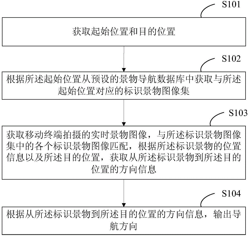
[0023] see figure 1 , figure 1 It is a schematic flow chart of the navigation method based on shooting scenes in the present invention.

[0024] The navigation method based on the photographed scene comprises the following steps:

[0025] S101, acquiring a starting position and a target position;

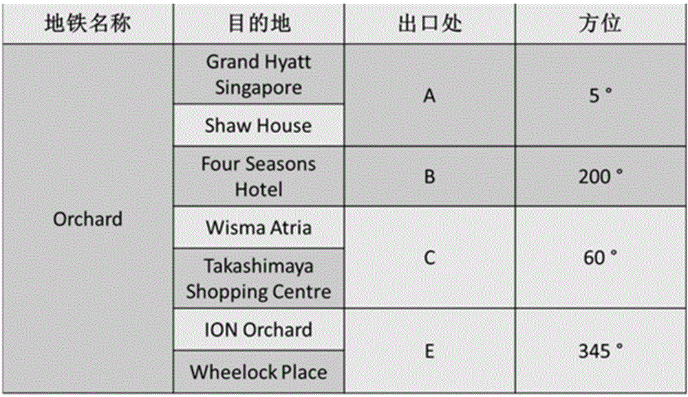
[0026] S102. Acquire a set of identified scene images corresponding to the initial position from a preset scene navigation database according to the initial position, wherein the set of identified scene images contains corresponding identified scene images, and each of the Identify the location information of the scene;

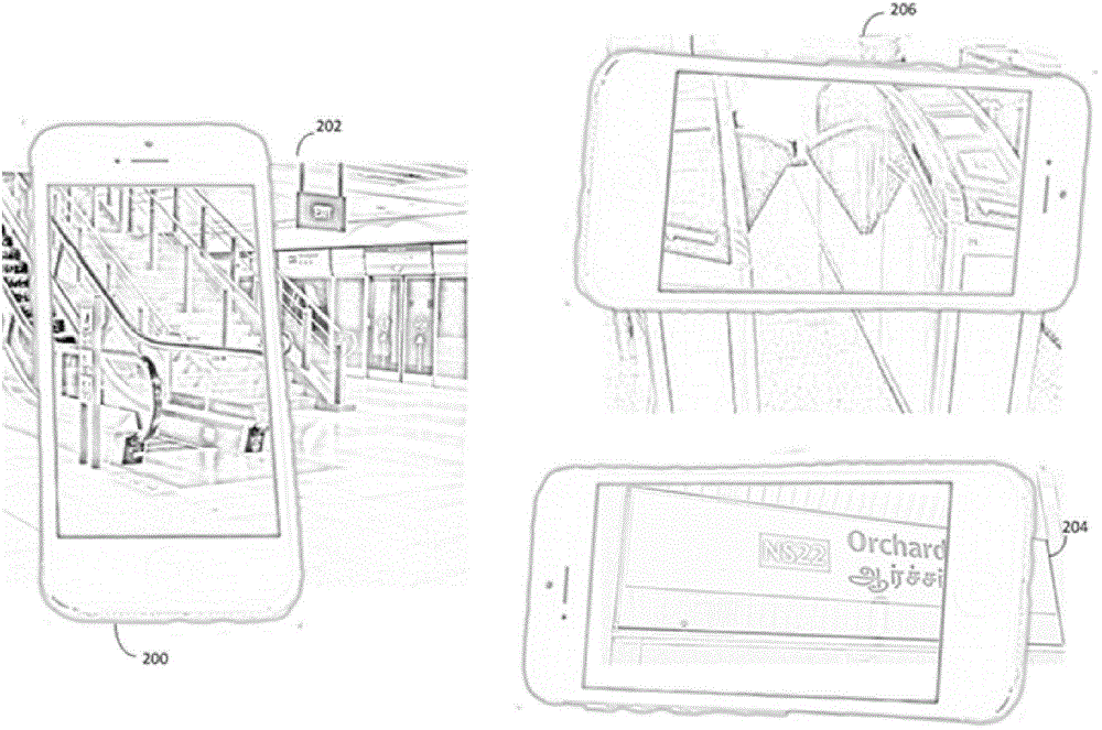
[0027] S103. Acquire a real-time scene image captured by the mobile terminal, and match the real-time scene image with each identified scene image in the set of identified scene images. If the matching is successful, according to the location information of the identified scene and the target location, Obtaining direction information from the identified scene t...


PUM


Abstract

The invention provides a shot scenery-based navigation method and a system thereof. The method comprises the following steps: presetting a scenery navigation database in a mobile terminal, and preserving identified scenery image sets of all indoor environments needing navigation; identifying the identified scenery image set of the corresponding indoor environment needed by a current user according to an initial position when the user inputs the initial position and the destination position of navigation; and shooting real-time scenery images nearby the initial position through the mobile terminal, such as the shooting device of an intelligent mobile phone by the user, matching the real-time scenery images with all the identified scenery images in the database through a program to identify corresponding identified sceneries in order to determine the direction information from the identified sceneries to the destination position, and outputting a navigation direction. Dependence of a GPS system is not needed, and the method can realize indoor environment navigation when the user is in indoor environment with a poor GPS signal.

Description

technical field [0001] The invention relates to the technical field of navigation, in particular to a navigation method based on photographed scenery and a navigation system based on photographed scenery. Background technique [0002] In recent years, electronic digital technology has been continuously progressing and developing. Modern people use many multifunctional electronic products and devices in their daily life to make life much more convenient. One of them is the smartphone, which is becoming more and more popular due to its diverse functions and shapes. One of the functions of the multi-functional smartphone is to have a Global Positioning System (GPS). The basic principle of GPS is to measure the distance between the user receiver and the satellites near a certain moving distance, and then integrate the data of multiple satellites to obtain the specific position. The smart phone uses the GPS signal to allow the user to carry out mobile navigation system through ...

Claims


Application Information

Patent Timeline
Patent Type & Authority Applications(China)
IPC IPC(8): G01C21/34
CPCG01C21/00
Inventor 周志颖李近綸
Owner NAT UNIV OF SINGAPORE SUZHOU RES INST
Why Eureka
Try Eureka