
Device and method for road surface identification in low-definition video streaming

A low-definition, road surface recognition technology, applied in the field of road surface recognition, can solve problems such as the inability to accurately detect the road surface range, the inability to obtain V/U disparity maps, and noise sensitivity

Inactive Publication Date: 2015-09-09
HITACHI LTD
View PDF4 Cites 16 Cited by
  • Summary
  • Abstract
  • Description
  • Claims
  • Application Information

AI Technical Summary

Problems solved by technology

[0007] However, the traditional V / U disparity algorithm has certain limitations in practical application.
First of all, when the car is driving on poor road conditions, especially in the wild environment, the camera itself has a non-negligible rotation angle caused by the bumps of the car body, which causes a large number of error points in the synthesized disparity map, and the V / U disparity map is better than that of the smooth road condition. Alternative mapping line segments for are thicker
If the performance of the vehicle camera selected at this time is poor and the pixels of the video stream collected are low, this will lead to the inability to obtain a finer V / U disparity map, resulting in the inability to accurately detect the range of the road surface
Moreover, the driving assistance system needs to be processed in real time, generally because the system performance cannot obtain dense disparity maps in real time
On the other hand, in the traditional V / U disparity algorithm, straight line fitting methods such as Hough transform are used to fit road mapping line segments and obstacle mapping line segments, but these methods are very sensitive to noise and cannot be handled well. Alternative mapping U / V disparity map with thicker line segments
Third, some obstacles with smaller shapes or less textures in the V disparity map are likely to be mistaken for road map line segments or noise

Method used


Image

  • Device and method for road surface identification in low-definition video streaming
  • Device and method for road surface identification in low-definition video streaming
  • Device and method for road surface identification in low-definition video streaming

Examples


Embodiment Construction

[0028] The present invention will be described in detail below in conjunction with the accompanying drawings.

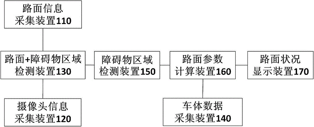
[0029] figure 1 is a block diagram showing the structure of a low-definition video information environment recognition driving assistance apparatus according to an embodiment of the present invention.

[0030] Such as figure 1 As shown, the surrounding environment recognition driving assistance device according to the present invention may include: a road surface information collection device 110, a camera information collection device 120, a road surface + obstacle area detection device 130, a vehicle body data collection device 140, and an obstacle area detection device 150 , a road surface parameter calculation device 160 , and a road surface condition display device 170 . According to the present invention, the surrounding environment recognition driving assistance device can be mounted on a vehicle or the like to assist the driving of the vehicle or the like i...


PUM


Abstract

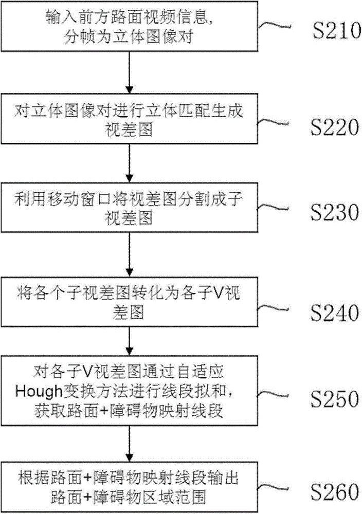
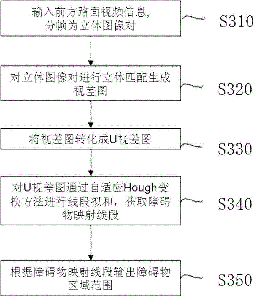
The invention puts forward a device for road surface identification in low-definition video streaming. The device comprises a road surface information collecting device with a binocular camera system, wherein the road surface information collecting device uses the binocular camera system to shoot road ahead of a vehicle so as to collect video information of the road ahead; a road surface or roadblock region detection device for converting the video information of the road ahead collected by the road surface information collecting device into a disparity map, converting the disparity map into a series of sub-V disparity maps and U disparity maps, performing adaptive line segment fitting to each sub-V disparity map and each U disparity map by using adaptive Hough transform, fitting mapping line segments of the road surface and the roadblock in each sub-V disparity map, and obtaining regional ranges of the road surface and the roadblock according to the mapping line segments of the road surface and the roadblock, fitting a mapping line segment of the roadblock in the U disparity maps, and obtaining a regional range of the roadblock according to the mapping line segment of the roadblock.

Description

technical field [0001] The invention relates to a device and method for road surface recognition in low-definition video streams, which can be used for low-definition video streams, especially for road surface recognition in outdoor environments, and improves the line segment fitting of V / U disparity map Accuracy. Background technique [0002] Unmanned vehicles usually have cognitive driving environment and automatic driving functions. Among them, the feasible road area detection is an important part of the cognitive driving environment function. The data information collected by the camera equipment in the road surface information collection instrument is far more accurate and reliable than the data information collected by the ranging sensor, and its image information covers a larger area. [0003] Road surface detection based on camera information usually uses simple two-dimensional image data (including information such as color and contour) for road surface detection....

Claims


Application Information

Patent Timeline
IPC IPC(8): H04N13/02H04N13/00
Inventor 戴依若王文佳川股幸博
Owner HITACHI LTD
Learn More