
Power line patrol unmanned aerial vehicle navigation system based on GPS RTK technology

A technology of navigation system and power line patrol, applied in radio wave measurement system, satellite radio beacon positioning system, overhead line/cable equipment and other directions, can solve the problem of positioning accuracy error, and achieve the effect of improving accuracy

Active Publication Date: 2015-09-23
GUANGDONG POWER FLY AIR TECH DEV CO LTD
View PDF4 Cites 72 Cited by
  • Summary
  • Abstract
  • Description
  • Claims
  • Application Information

AI Technical Summary

Problems solved by technology

The positioning accuracy of GPS is affected by error sources such as satellite clock error, satellite orbit error, ionosphere, troposphere, multipath effect, antenna phase center deviation, and receiver clock error. At present, the positioning accuracy of GPS stand-alone is about 10m. In fact, this still cannot meet the GPS accuracy requirements of the power line patrol UAV navigation system.

Method used


Image

  • Power line patrol unmanned aerial vehicle navigation system based on GPS RTK technology
  • Power line patrol unmanned aerial vehicle navigation system based on GPS RTK technology
  • Power line patrol unmanned aerial vehicle navigation system based on GPS RTK technology

Examples


Embodiment Construction

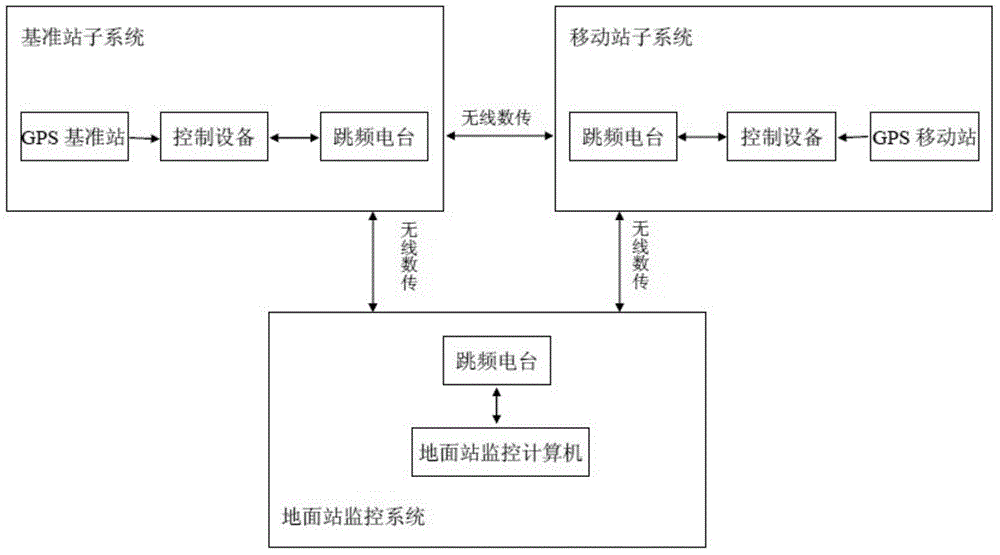
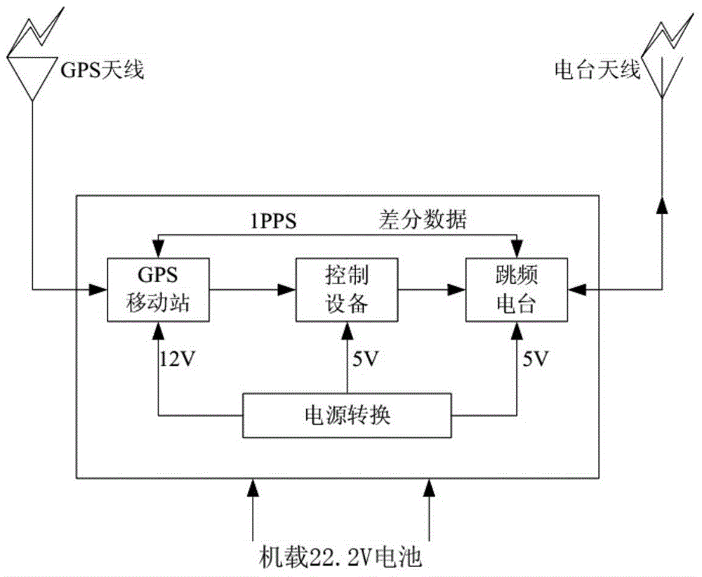
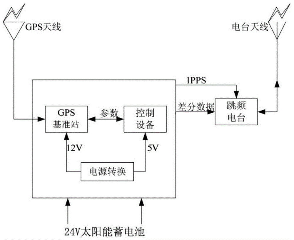
[0020] A GPS RTK technology-based power line patrol UAV navigation system provided by the present invention will be described in detail below in conjunction with the accompanying drawings and specific embodiments.

[0021] In the following description, various aspects of the present invention will be described. However, those skilled in the art can implement the present invention by using only some or all of the structures or processes of the present invention. For clarity of explanation, specific numbers, arrangements and sequences are set forth, but it will be apparent that the invention may be practiced without these specific details. In other instances, well-known features have not been described in detail in order not to obscure the invention.

[0022] With the rapid development of satellite positioning technology, people's demand for fast and high-precision location information is also increasing. At present, the most widely used high-precision positioning technology is...


PUM


Abstract

The invention provides a power line patrol unmanned aerial vehicle navigation system based on GPS RTK technology. The power line patrol unmanned aerial vehicle navigation system comprises one or a plurality of unmanned aerial vehicle movement stations, a plurality of reference station subsystems and a ground station monitoring subsystem. The plurality of reference station subsystems are respectively configured on power line towers, wherein the plurality of reference station subsystems are used for transmitting GPS differential data to the unmanned aerial vehicle movement stations through a wireless data transmission system. The unmanned aerial vehicle movement stations are used for obtaining centimeter-grade-precision navigation information through the GPS RTK differential technology. Furthermore real-time monitoring for the unmanned aerial vehicle movement stations and each reference station subsystem by the ground station monitoring subsystem is realized through the wireless data transmission system.

Description

technical field [0001] The present invention relates to power equipment and unmanned aerial vehicle navigation technology, more specifically, relates to a kind of electric line patrol unmanned aerial vehicle navigation system based on GPSRTK technology. Background technique [0002] For power lines that pass through virgin forest edge areas, high altitudes, and snow-covered areas, there are frequent landslides, mudslides and other geological disasters along some lines, and most areas have high mountains and steep slopes. When transportation and communication are extremely underdeveloped, daily inspections of power lines become a difficult task. [0003] The traditional power line and pipeline inspection process is that the staff go to the site to inspect the line in person. The inspection objects are mainly power facilities, including towers, wires, transformers, insulators, crossarms, knife switches and other equipment, and the inspection situation is recorded in the form o...

Claims


Application Information

Patent Timeline
IPC IPC(8): G01S19/07G01S19/41H02G1/02
CPCG01S19/41G01S19/426G01S19/44
Inventor 邓海辉欧健
Owner GUANGDONG POWER FLY AIR TECH DEV CO LTD
Features
  • Generate Ideas
  • Intellectual Property
  • Life Sciences
  • Materials
  • Tech Scout
  • Unparalleled Data Quality
  • Higher Quality Content
  • 60% Fewer Hallucinations
Learn More