Power-grid-GIS-based real-time early warning method and apparatus of satellite cloud picture

A technology of satellite cloud images and early warning devices, applied in measuring devices, ICT adaptation, instruments, etc., can solve problems such as frequent occurrence of disaster weather and safety hazards of power grid operation, and achieve the effects of reducing power grid losses, improving accuracy, and reducing waste of emergency resources

Inactive Publication Date: 2015-09-30
EMERGENCY MANAGEMENT CENT OF STATE GRID SHANDONG ELECTRIC POWER
View PDF4 Cites 14 Cited by
  • Summary
  • Abstract
  • Description
  • Claims
  • Application Information

AI Technical Summary

Problems solved by technology

[0002] Disaster weather occurs frequently, which brings great harm to the safety of power grid operation

Method used


Image

  • Power-grid-GIS-based real-time early warning method and apparatus of satellite cloud picture

Examples


Embodiment Construction

[0039] Below in conjunction with accompanying drawing and embodiment the present invention will be further described:

[0040] The system architecture of the present invention adopts the J2EE multi-layer architecture, which has good scalability, is convenient for system interconnection, has high security, and is also easy to maintain and manage. At the same time, the standard J2EE multi-layer system and component design are adopted to provide a reliable underlying foundation for the operation of the platform system, making the system development faster and more efficient, and the system's security, scalability, portability, usability, and ease of use. Maintainability is strongly guaranteed.

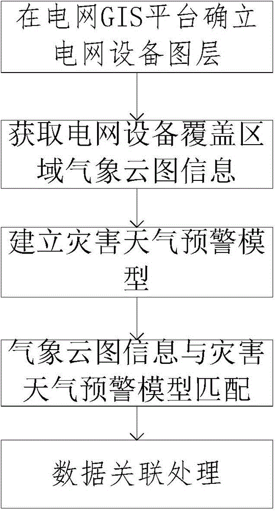
[0041] The real-time early warning method of satellite cloud image based on power grid GIS comprises the following steps:

[0042] (1) In the grid GIS platform, locate the coordinates of the grid equipment in the early warning area; establish the grid equipment layer according to the coo...


PUM


Abstract

The invention discloses a power-grid-GIS-based real-time early warning method and apparatus of a satellite cloud picture. The method comprises: a power grid equipment coordinate at an early warning area is localized; a power grid equipment graph layer is determined according to the coordinate of the power grid equipment; the power grid equipment at the specific longitude and latitude is monitored in real time and meteorological data in meteorological cloud picture information of the power grid equipment coverage area are obtained; matching of the monitored meteorological data in meteorological cloud picture information and a disaster weather early warning model is carried out to determine a disaster weather type; a disaster weather chart layer is established on the power grid GIS according to the longitude and latitude positioning information; and the data association processing is carried out to realize regional refined power grid meteorological disaster early warning at different time intervals. The method and system have the following beneficial effects: a professional early warning model for disaster weather can be established and regional refined early warning for power facilities at different time intervals can be realized; disaster destructiveness is effectively reduced; and targeted measures and specifications for wind prevention can be formulated; and the losses of the power grid can be reduced.

Description

technical field [0001] The invention belongs to the field of meteorological early warning of electric power systems, in particular to a method and device for real-time early warning of satellite cloud images based on power grid GIS. Background technique [0002] Disaster weather occurs frequently, which brings great harm to the safety of power grid operation. A satellite cloud image is a top-down image of cloud cover and surface features on Earth as observed by weather satellites. The use of satellite cloud images can identify different weather systems, estimate their strength and development trends, and provide a basis for weather analysis and weather forecasting. [0003] Through the shape, structure, brightness and texture characteristics of satellite cloud images, the species, genus and precipitation status of clouds can be identified. It can identify a wide range of cloud systems, such as spirals, ribbons, commas, waves, cells, etc., and use them to infer the location...

Claims


Application Information

Patent Timeline
Patent Type & Authority Applications(China)
IPC IPC(8): G01W1/00G01W1/02
CPCG01W1/00G01W1/02Y02A90/10
Inventor 牛进苍李红梅孙世军杨啸帅王勇张治取孙为民韩洪王波张鹏程中华
Owner EMERGENCY MANAGEMENT CENT OF STATE GRID SHANDONG ELECTRIC POWER
Why Eureka
Try Eureka