Multi-source data fusion-based three-dimensional ionosphere chromatographic method

A multi-source data and ionospheric technology, applied in the field of satellite geodetic survey and space environment detection, can solve the problems of unachievable tomographic effect, low vertical accuracy of GPS tomography, and uneven distribution of data and information.

Inactive Publication Date: 2015-11-04
EAST CHINA JIAOTONG UNIVERSITY
View PDF3 Cites 22 Cited by
  • Summary
  • Abstract
  • Description
  • Claims
  • Application Information

AI Technical Summary

Problems solved by technology

Chartier et al. used incoherent scattered radar observations as background values, fused altimeter data to improve the vertical accuracy of GPS ionospheric tomography, and effectively overcome the shortcomings of low vertical accuracy of GP...

Method used


Image

  • Multi-source data fusion-based three-dimensional ionosphere chromatographic method
  • Multi-source data fusion-based three-dimensional ionosphere chromatographic method
  • Multi-source data fusion-based three-dimensional ionosphere chromatographic method

Examples


Embodiment Construction

[0039] The present invention will be further described below in conjunction with the accompanying drawings and specific embodiments, but the scope of the present invention is not limited to the following embodiments.

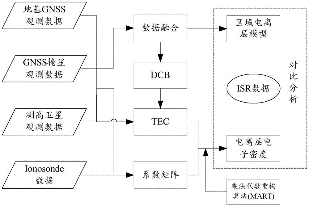
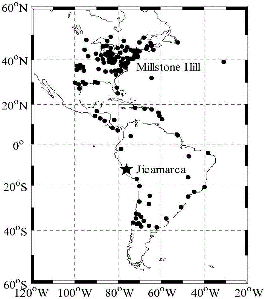
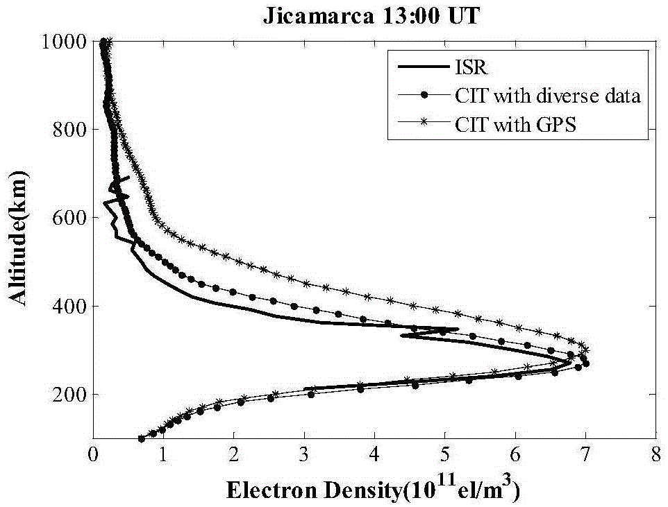
[0040] The observation data used in the present invention comes from the IGS observation network, and the station observation information in the reconstruction area is selected for reconstruction, and the incoherent scattering radar Jicamarca (76°W, 11.9°S) and Millstone Hill (71.5°W, 42.6°S) are used to reconstruct °N) station observation data for independent verification. Station distribution as figure 2 As shown, "●" in the figure is an IGS station, and "" is an incoherent scatter radar station.

[0041] Step (1), determine the scope of the target area, select GNSS observation data, occultation observation data on low-orbit satellites, Jason-1 and Jason-2 marine satellite altimetry data and ionospheric altimeter data within the area;

[0042] Select the da...


PUM


Abstract

The invention discloses a multi-source data fusion-based three-dimensional ionosphere chromatographic method, utilizes GNSS observation data, occultation observation data on low orbit satellites, Jason-1 and Jason-2 seasat altimetry data and ionosphere altimeter data for the first time, and develops research on ionosphere electron density tomography. An inversion result is compared with observation data of an incoherent scattering radar, and a result verifies effectiveness and reliability of the three-dimensional ionosphere chromatographic method provided by the invention in fusing multi-source data to perform inversion of ionosphere electron density and superiority of the method to use of GPS observation data alone to perform inversion.

Description

technical field [0001] The invention relates to the fields of satellite geodesy and space environment detection, in particular to a three-dimensional ionospheric tomography method based on multi-source data fusion. Background technique [0002] Ionospheric tomography technology uses GNSS signals to reconstruct the two-dimensional, three-dimensional and even four-dimensional electron density distribution of the ionosphere. It is especially suitable for monitoring the large-scale spatial distribution of the ionospheric space environment, and the construction and operation costs are relatively low, so it has attracted the attention of ionospheric researchers and has achieved many research results. However, due to the limitation of the spatial distribution and quantity of ground stations and satellites, the coverage and uniformity of the effective observation information for inversion are insufficient. Therefore, when using GNSS observation data for ionospheric tomography, only ...

Claims


Application Information

Patent Timeline
IPC IPC(8): G01S7/41
CPCG01S7/41
Inventor 汤俊
Owner EAST CHINA JIAOTONG UNIVERSITY
Why Eureka
Try Eureka