Geospatial data based user privacy protection method and system

A geospatial data and user privacy technology, applied in digital data protection, geographic information database, special data processing applications, etc., can solve the problem of not giving tree depth or division granularity, not considering the cell area factor, and inconsistent with data query. actual situation, etc.

Active Publication Date: 2015-11-18
WUHAN UNIV
View PDF3 Cites 19 Cited by
  • Summary
  • Abstract
  • Description
  • Claims
  • Application Information

AI Technical Summary

Problems solved by technology

For two-dimensional geospatial data, when the data domain is segmented through the tree structure to improve data availability, the tree depth is the key factor affecting the data query results, and the above literature does not provide theoretical support for the specific tree depth or partition granularity
Starting from the granularity of the data domain, Qardaji et al. studied how to construct a differentially private data set, an

Method used


Image

  • Geospatial data based user privacy protection method and system
  • Geospatial data based user privacy protection method and system
  • Geospatial data based user privacy protection method and system

Examples


Embodiment Construction

[0075] The present invention proposes a user privacy protection method for geospatial data, which proposes a data domain granularity division model that is more in line with the actual situation of data query based on noise error and uniform assumption error. Through this model, more accurate The data space is divided to improve data query accuracy and data availability; the invention also designs the merging of similar cells in the data space, further improving data availability. In order to make the object, technical solution and advantages of the present invention clearer, the present invention will be further described in detail below in combination with specific implementation cases and with reference to the accompanying drawings.

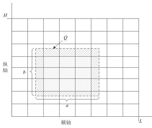
[0076] figure 1 Shown is the query schematic diagram of the data query Q of the present invention. As shown in the figure, the query Q is a dotted box, and Q intersects with the cells in the data space. The shaded part in the figure is the are...


PUM


Abstract

The invention provides a geospatial data based user privacy protection method and system. The method comprises: partitioning data space; combining similar cells to the same partition based on a uniformity measurement parameter; adding random noise conforming to Laplace distribution into each partition to obtain a noise data set; and externally providing a data query result based on the noise data set. The invention, based on analysis of noise errors and uniform assumption errors, proposes a novel data field granularity partitioning model for balancing the noise errors and the uniform assumption errors to minimize total data query errors. A condition that query is rectangular query is considered when the model is created, so that an actual data query condition is better met. Furthermore, the similar cells in the data space are combined, so that the query error of the geospatial data is smaller, and the data availability is greatly enhanced while the record security of user privacy is protected.

Description

technical field [0001] The invention belongs to the field of information security and privacy protection, and in particular relates to a user privacy protection method and system for geospatial data. Background technique [0002] The rapid development of the information age has made it easier to obtain data, such as user's mobile trajectory data, shopping record data, and office / home address data. All these data composed of location points are called geospatial data. Through the analysis of geospatial data, a lot of useful information can be obtained. For the transportation department, the current traffic conditions can be obtained by analyzing the user's movement trajectory data, and provide data support for urban traffic control; for the merchants, the user's shopping record data or vehicle movement trajectory data can be analyzed to obtain the areas or clusters that the user is interested in To provide data support for commercial layout; for the urban planning bureau, it...

Claims


Application Information

Patent Timeline
IPC IPC(8): G06F21/62G06F17/30
CPCG06F16/29G06F21/6245
Inventor 刘树波王俊李永凯蔡朝晖
Owner WUHAN UNIV
Why Eureka
Try Eureka