Unmanned aerial vehicle autonomous navigation system and method based on image processing and radar

An autonomous navigation system and image processing technology, applied in the field of UAV navigation, can solve the problems of few technologies, solution application, judging flight routes and flight paths, etc., and achieve a wide range of applications, strong scalability, and good autonomous navigation effect of effect

Inactive Publication Date: 2015-12-16
NANJING UNIV OF SCI & TECH
View PDF6 Cites 34 Cited by
  • Summary
  • Abstract
  • Description
  • Claims
  • Application Information

AI Technical Summary

Problems solved by technology

[0002] Nowadays, the utilization rate of drones is increasing day by day, but due to the limitations of the drone platform, it is impossible to judge the route and flight path by itself, so there are few technologies that can truly realize autonomous navigation flight
[0003] At present, the solution to UAV navigation is GPS navigation, and the methods to realize autonomous navigation include infrared scanning map drawing method and indoor visual system navigation method. Since these methods are still in laboratory research, there is no good solution application. In the field of unmanned aerial vehicles

Method used


Image

  • Unmanned aerial vehicle autonomous navigation system and method based on image processing and radar
  • Unmanned aerial vehicle autonomous navigation system and method based on image processing and radar

Examples


Embodiment 1

[0037] In this embodiment, taking a traffic accident and tracking the vehicle involved in the accident as examples, the present invention is further described in detail.

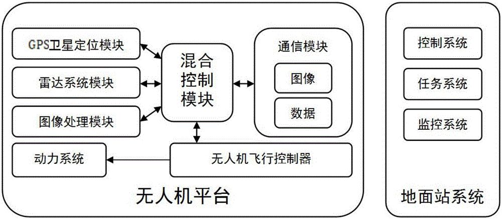
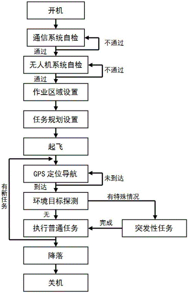
[0038] The present invention is based on image processing and radar UAV autonomous navigation system and method, the system includes traffic UAV control terminal and patrol UAV distributed in the city; traffic patrol UAV hardware includes UAV platform, image processing module, radar system module and hybrid control unit module, the image processing module is divided into high-speed camera Gopro camera, Feiyu MINI gimbal and Android embedded MK802IV image processing unit module; the radar system module is divided into microwave millimeter wave radar module, high-speed FPGA signal The processing module; the hybrid control module includes a high-speed Linux embedded processing unit of the UAV and is connected with the UAV aircraft control unit; the traffic UAV control terminal tracks and locks the UAV in real ti...


PUM


Abstract

The invention discloses an unmanned aerial vehicle autonomous navigation system and method based on image processing and radar. The system comprises an unmanned aerial vehicle platform and a ground station system, wherein a GPS satellite positioning module, an image processing module, a radar system module and a hybrid control module are arranged on the unmanned aerial vehicle platform; the hybrid control module is connected with the GPS satellite positioning module, the image processing module, the radar system module, an unmanned aerial vehicle flight controller and a communication module; the image processing module comprises a high-speed camera, a camera holder unit and an image processing unit; the radar system module comprises a microwave and millimeter wave radar unit and a signal processing unit; the hybrid control module comprises an unmanned aerial vehicle high-speed embedded-type processing unit. According to the method, a sensor group, the image processing module and the radar system module periodically acquire effective information, and feed back the acquired effective information to the hybrid control module for classified processing, so that autonomous navigation of an unmanned aerial vehicle can be achieved. The system provided by the invention is advanced and high in expansibility; through adoption of the system, the autonomous navigation effect of an automated unmanned aerial vehicle can be very good.

Description

technical field [0001] The invention belongs to the technical field of drone navigation, in particular to an image processing and radar-based autonomous navigation system and method for drones. Background technique [0002] Nowadays, the utilization rate of drones is increasing day by day, but due to the limitations of the drone platform, it is impossible to judge the route and flight path by itself, so there are few technologies that can truly realize autonomous navigation and flight. [0003] At present, the solution to UAV navigation is GPS navigation, and the methods to realize autonomous navigation include infrared scanning map drawing method and indoor visual system navigation method. Since these methods are still in laboratory research, there is no good solution application. in the field of unmanned aerial vehicles. Contents of the invention [0004] The purpose of the present invention is to provide a safe, reliable, flexible and widely used UAV autonomous navigat...

Claims


Application Information

Patent Timeline
Patent Type & Authority Applications(China)
IPC IPC(8): G01C21/20G01S19/48
CPCG01C21/20G01S19/48
Inventor 刘裕卢加文吴礼
Owner NANJING UNIV OF SCI & TECH
Why Eureka
Try Eureka