Establishing method for reference sample plot used for remote sensing monitoring of alpine grassland

A technology for remote sensing monitoring and establishing methods, which is applied in the directions of measuring devices, surveying and navigation, photogrammetry/video metrology, etc., which can solve the problems of large amounts of data and inability to monitor continuously, and achieve a comprehensive and repeatable system. Effect

Inactive Publication Date: 2015-12-16
LANZHOU UNIVERSITY
View PDF5 Cites 5 Cited by
  • Summary
  • Abstract
  • Description
  • Claims
  • Application Information

AI Technical Summary

Problems solved by technology

The reference sample plot can only be used as a sample plot for basic information acquisition. Due to its

Method used


Image

  • Establishing method for reference sample plot used for remote sensing monitoring of alpine grassland
  • Establishing method for reference sample plot used for remote sensing monitoring of alpine grassland
  • Establishing method for reference sample plot used for remote sensing monitoring of alpine grassland

Examples


Embodiment 1

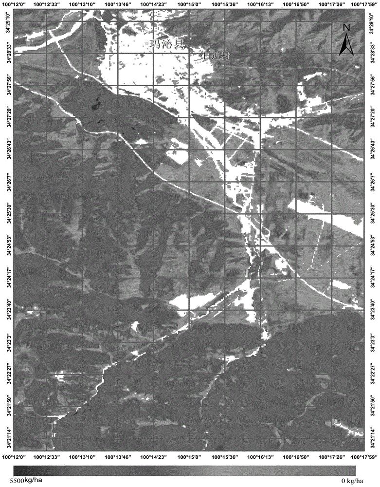
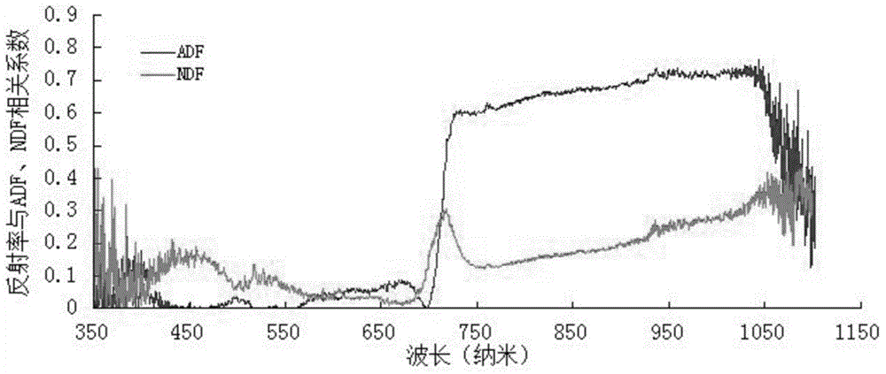
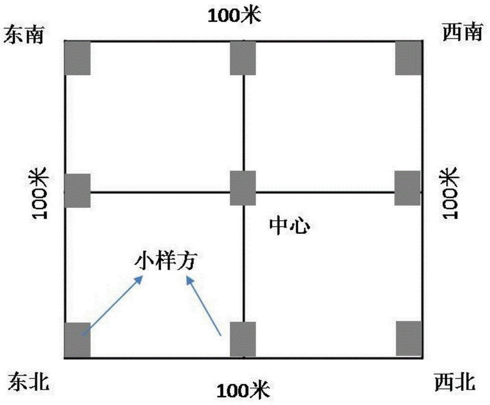
[0035] The technical scheme is implemented in the alpine grassland of Maqin County, Qinghai Province. Determine the scope of alpine grassland survey, determine the basic vegetation types from remote sensing images, and determine the control plots according to the type and range. As a whole, a control sample plot is determined for each type and each terrain. Determine the reference sample plot in the control sample plot. The reference sample plot covers as much information as possible according to the specific ground conditions, including disturbance, vegetation composition, topography, soil and other characteristics. The tools used include differential GPS, 100-meter ruler, triangular iron column, and related vegetation survey tools. The result is as Figure 1-4 shown.

[0036] A method for establishing a reference sample plot for remote sensing monitoring alpine grassland, comprising the following steps:

[0037] (1) Select areas with more community types, more terrains,...


PUM


Abstract

The invention discloses an establishing method for a reference sample plot used for remote sensing monitoring of alpine grassland. According to the invention, ground survey is carried out on the basis of determination of one hectare of a reference sample plot, wherein the area of the reference sample plot can cover more information including a plurality of information like vegetation, soil, terrain and interference; positioning accuracy guaranteed by differential GPS can provide more accurate interpretation information for high spectral remote sensing; unreliable information in data of 9 control quadrats can be removed according to a data confidence interval, and strong noisy data removing capability is obtained; the reference sample plot has good repeatability and verifiability, so the defect that conventional meadow survey cannot be reproduced is overcome; and the method has strong information integration capability, information like species, soil, hydrology, microorganisms, isotope and heredity except vegetation can be simultaneously acquired and brought into an information platform according to research and monitoring needs, so the method provides technology and standards for further enlargement of construction of a reference sample plot network of the alpine grassland in China.

Description

technical field [0001] The invention relates to the field of grassland monitoring, in particular to a method for establishing a reference plot for remote sensing monitoring alpine grassland. Background technique [0002] As an important land, agriculture, and ecological resource, grassland is becoming more and more important in national resource and environmental management. Among them, the alpine grassland occupies 51% of the land area of ​​the Qinghai-Tibet Plateau, and is an important foundation for the ecology, production and life of local people in the alpine region of our country. Therefore, the health of alpine grassland plays an important role in maintaining ecological security in alpine areas, as well as social and economic development and stability. Therefore, the monitoring and evaluation of grassland health in my country's land, agriculture, and environmental management departments are very critical, and the requirements for more accurate methods are gradually i...

Claims


Application Information

Patent Timeline
IPC IPC(8): G01N33/00G01C11/00
Inventor 尚占环侯尧宸董全民白彦福冯琦胜丁路明施建军
Owner LANZHOU UNIVERSITY
Why Eureka
Try Eureka