Indoor three-dimensional space real-time route navigation method and system

A real-time path and three-dimensional space technology, applied in the field of indoor navigation, can solve the problem of not being able to find the destination correctly and quickly, and achieve the effect of saving time and avoiding congestion

Active Publication Date: 2015-12-30
SHENZHEN BOKANG SYST ENG
View PDF3 Cites 22 Cited by
  • Summary
  • Abstract
  • Description
  • Claims
  • Application Information

AI Technical Summary

Problems solved by technology

[0007] Aiming at the problems existing in the above-mentioned prior art, the present invention proposes an indoor three-dimensional space real-time path navigation method and navigation system, which full

Method used


Image

  • Indoor three-dimensional space real-time route navigation method and system
  • Indoor three-dimensional space real-time route navigation method and system
  • Indoor three-dimensional space real-time route navigation method and system

Examples


Embodiment 1

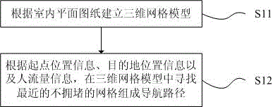
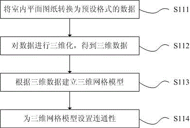
[0061] combine Figure 2-3 , this embodiment describes step S11 in detail, which specifically includes the following steps:

[0062] S111: Convert the indoor floor plan into data in a preset format;

[0063] S112: 3Dize the data to obtain 3D data;

[0064] S113: establish a 3D mesh model according to the 3D data;

[0065] S114: Set connectivity for the three-dimensional mesh model, i.e. passable and impassable.

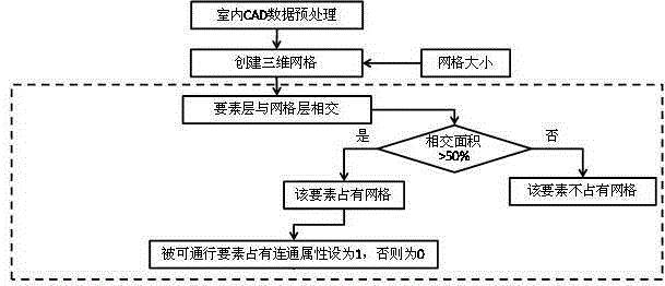
[0066] Wherein, step S111 is specifically: using CAD plan drawings, retaining the outlines of indoor planes, doors, stairs and obstacles (including pillars, walls, furniture and other obstacles), and converting the geographic information system software (ArcMap) to obtain a format of .shp data, and correct the incorrectly converted data by vectorization; then convert the converted data into surface elements through ArcMap, so as to facilitate the setting of the connectivity of the 3D mesh model.

[0067] Step S112 is specifically as follows: in the 3D geographic i...

Embodiment 2

[0072] combine Figure 4-5 , another method of S12 is described in detail in this embodiment, which includes the following steps:

[0073] S1201: Calculate the grid A where the starting point is located according to the starting point position information, and store the grid A in the open list;

[0074] S1202: Search for reachable grids around grid A, store the reachable grids in the open list, and set the parent grid of the reachable grids as grid A;

[0075] S1203: delete grid A from the open list, and add grid A to the close list;

[0076] S1204: Select the grid with the lowest objective function value in the open list, delete the selected grid B from the open list, and add it to the close list; wherein, the objective function is:

[0077] F=(1+a)*G+H

[0078] In the formula, G represents the time taken to move from grid A to the specified grid along the generated path; H represents the time required to move from the specified grid to the end point; a represents the coef...


PUM


Abstract

The invention discloses an indoor three-dimensional space real-time route navigation method and system. The method includes the steps that according to an indoor plane drawing, a three-dimensional mesh model is established; according to starting point position information, destination position information and human traffic information, closest non-jamming meshes are searched for to form a navigation route in the three-dimensional mesh data model. The system comprises a collector, a receiver and a processor, wherein the collector is used for collecting the starting point position information and the human traffic information, the receiver is used for receiving the starting point position information and the indoor human traffic information collected by the collector and further used for receiving the destination position information, and the processor is used for processing the starting point position information, destination position information and indoor human traffic information received by the receiver, so that the navigation route is obtained. The conditions of indoor environment obstacles and human traffic distribution are sufficiently considered, and workers can rapidly reach a destination in a strange environment.

Description

technical field [0001] The invention relates to the technical field of indoor navigation, in particular to a real-time path navigation method and a navigation system in an indoor three-dimensional space. Background technique [0002] Global Positioning System (GPS) and Beidou satellite navigation system have been widely used in all walks of life because of the characteristics of all-weather, continuous and real-time work on a global scale. Among them, the application closest to daily life is outdoor positioning and navigation. At the same time, with the popularization of smart phones and the development of the mobile Internet, more and more apps based on geographic location appear in the application market. Even in an unfamiliar place, it only takes a few seconds to search where you want to go and the surrounding facilities and shops, and the app will indicate how to get to the destination from the current location as quickly as possible, providing people with free travel i...

Claims


Application Information

Patent Timeline
IPC IPC(8): G01C21/00
CPCG01C21/00
Inventor 谢君
Owner SHENZHEN BOKANG SYST ENG
Why Eureka
Try Eureka