Early warning method against vehicle collision based on electronic map

An electronic map and vehicle collision technology, applied in the field of intelligent transportation, can solve the problems of sensor stability reduction and drop

Active Publication Date: 2015-12-30
TONGJI UNIV
View PDF5 Cites 53 Cited by
  • Summary
  • Abstract
  • Description
  • Claims
  • Application Information

AI Technical Summary

Problems solved by technology

Ultrasonic sensors The stability of vehicle sensors is easily affected by factors such as the environment and weather, so the performance of sensor-based vehicle active safety applications will drop significantly due to the decrease in sensor stability

Method used


Image

  • Early warning method against vehicle collision based on electronic map
  • Early warning method against vehicle collision based on electronic map
  • Early warning method against vehicle collision based on electronic map

Examples


Embodiment Construction

[0077] The present invention will be described in detail below with reference to the drawings and specific embodiments.

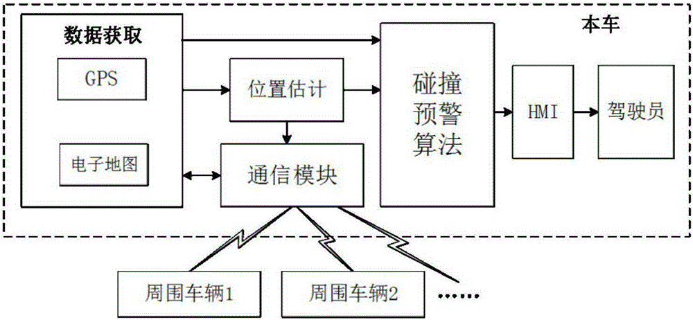
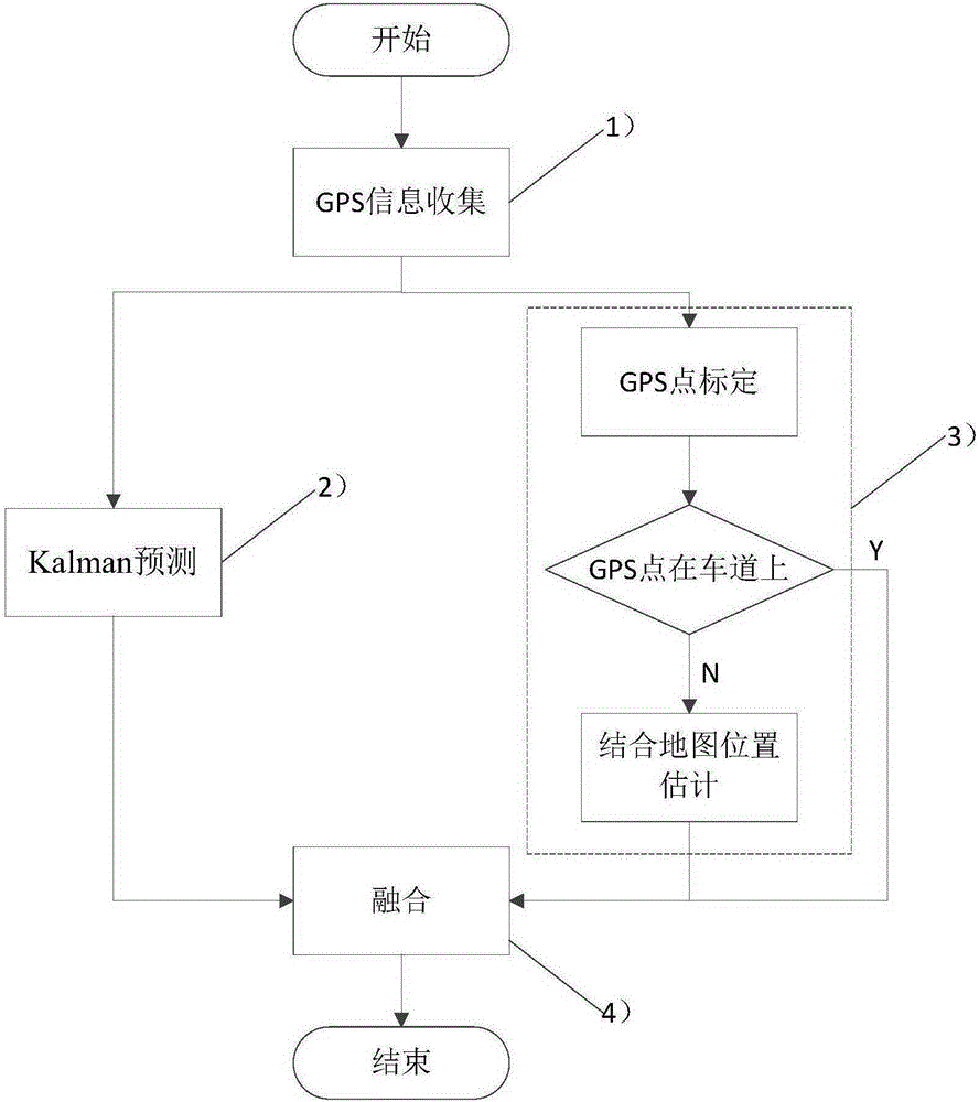
[0078] An electronic map-based vehicle collision warning method is based on the sharing and exchange of vehicle motion state information and location information between the vehicle and neighboring vehicles, and combines the electronic map information to assist collision warning, and finally the human-machine interface HMI informs the driver of the alarm information. Such as figure 1 , figure 2 As shown, the method of the present invention specifically includes the following steps:

[0079] 1) Obtain the GPS data of the vehicle. The GPS data includes motion state information and position information, and use coordinate system conversion to map the vehicle position information (ie the GPS coordinates of the vehicle and the received GPS coordinates of other vehicles) to a two-dimensional rectangular coordinate system , Where the motion status information include...


PUM


Abstract

The invention relates to an early warning method against vehicle collision based on an electronic map. The method comprises that 1) GPS data, which comprises movement station information and position information, of a vehicle is obtained, and the position information of the vehicle is converted by a coordinate system and mapped into a two-dimensional rectangular coordinate system; 2) according to historical GPS data of the vehicle, the present position information of the vehicle is optimized in a Kalman filtering algorithm to predict a first present position of the vehicle; 3) according to the historical GPS data of the vehicle, information of the electronic map is combined to predict a second present position of the vehicle; 4) the first present position and the second present position of the vehicle are combined to predict the optimal position of the vehicle; and 5) the predicted optimal position of the vehicle is combined with a TCC algorithm to make early warning against collision. Compared with the prior art, whether the vehicle possibly collides with vehicles in the surrounding is predicted in real time, early warning is given to a driver in real time, the driving safety and the vehicle positioning precision are effectively improved, and the method is practical and efficient.

Description

Technical field [0001] The present invention relates to intelligent transportation technology in the Internet of Vehicles, in particular to a vehicle collision warning method based on an electronic map. Background technique [0002] The Internet of Vehicles is an important application of the Internet of Things in the field of intelligent transportation. Through information interaction, it connects cars, roads and pedestrians into a whole network, thereby achieving intelligent transportation. In terms of driving safety and intelligent transportation, the Internet of Vehicles is mainly based on vehicle-to-vehicle communication and vehicle-to-road communication to reliably share information in real time, thereby improving the efficiency of traffic flow and driving safety. Based on vehicle-to-vehicle communication or vehicle-to-vehicle communication, combined with vehicle-mounted GPS and electronic map information, the vehicle-mounted active safety system can inform the driver of pos...

Claims


Application Information

Patent Timeline
IPC IPC(8): G08G1/16
Inventor 王平刘富强王超王新红蔡雷潘云郑博文
Owner TONGJI UNIV
Why Eureka
Try Eureka