High-power zoom unmanned aerial vehicle aerial high-definition multi-dimension real-time investigation transmitting method

An unmanned aerial vehicle, high-power technology, applied in the field of unmanned aerial vehicle reconnaissance, can solve the problems of high cost, prohibitive initial construction cost and communication cost, large base station construction cost, etc., to meet the requirements of high-definition digital transmission and new technology. Development requirements, the effect of reducing the cost of communication broadband

Active Publication Date: 2015-12-30
CHENGDU TIMES TECH
View PDF6 Cites 4 Cited by
  • Summary
  • Abstract
  • Description
  • Claims
  • Application Information

AI Technical Summary

Problems solved by technology

However, the cost of these two technologies remains high, and their expensive initial construction costs and communication costs are often prohibitive and cannot be widely promoted.
[0006] WIMAX / WIFI and other technologies to build a wireless metropolitan area network for wide-area coverage video applications require the builder to build a large number of base stations. Due to the huge initial construction cost of the domain network, it is unwilling to share it with other users, thus causing a great waste of social resources

Method used


Image

  • High-power zoom unmanned aerial vehicle aerial high-definition multi-dimension real-time investigation transmitting method
  • High-power zoom unmanned aerial vehicle aerial high-definition multi-dimension real-time investigation transmitting method

Examples


Embodiment Construction

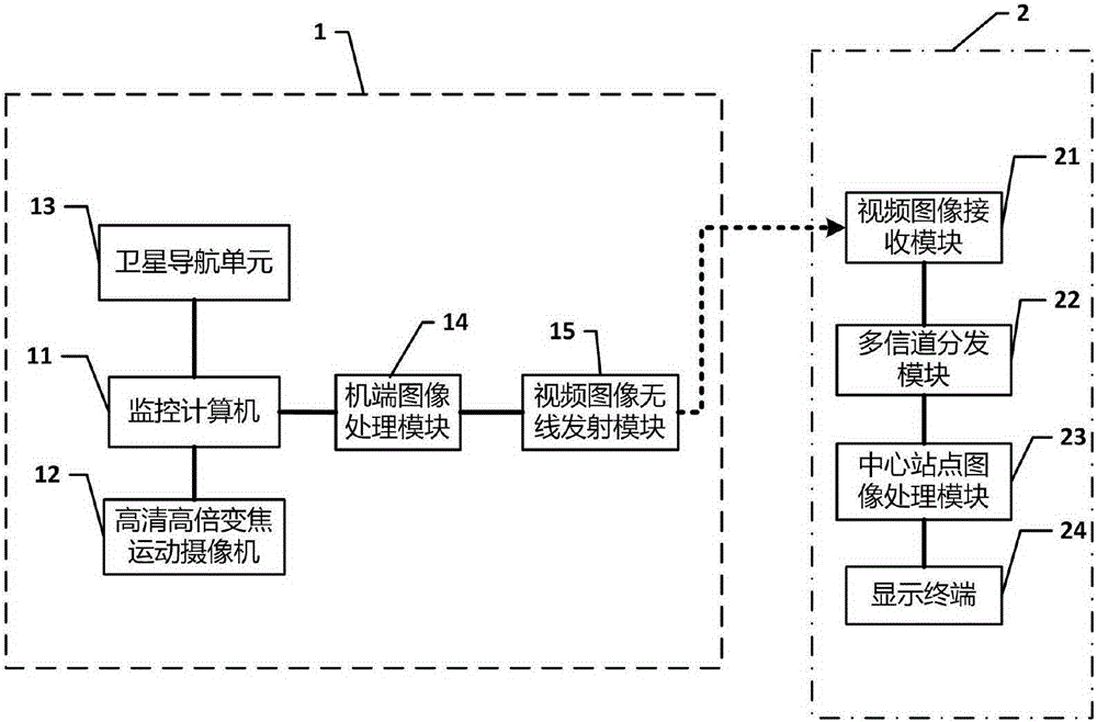
[0062] figure 1 It shows a high-magnification zoom unmanned aerial vehicle high-definition multi-dimensional real-time reconnaissance transmission system of the present invention. The system includes: an image monitoring device 1 installed in the drone and a video transmission device 2 installed in the ground central station.

[0063] Among them, the image monitoring device 1 includes: a monitoring computer 11 installed on the drone, a satellite navigation unit 13 , a high-definition high-magnification zoom motion camera 12 , a machine-side image processing module 14 and a video image wireless transmitting module 15 .

[0064] The monitoring computer 11 is also embedded with an Ethernet switching chip (LANswitch), and the Ethernet switching chip (LANswitch) is connected with the monitoring computer 11 (ARM) through a local area network (LAN),

[0065] The machine-side image processing module 14 is connected with the monitoring computer with a 100M Ethernet port, and receives ...


PUM


Abstract

The invention discloses a high-power zoom unmanned aerial vehicle aerial high-definition multi-dimension real-time investigation transmitting method. The method comprises the following steps that firstly, a monitoring computer starts a monitoring program, and a satellite navigation unit starts a GPS navigation program; secondly, a high-definition high-power zoom action camera collects video images according to the track of the monitoring program, and a vehicle-side image processing module processes the images; thirdly, a video image wireless transmitting module and a video image receiving module cooperate to complete wireless sending and receiving of image signals; fourthly, a central station image processing module processes the received image signals, and the received image signals are displayed on a terminal. According to the method, visual navigation, image recognition and obstacle avoidance are supported, parameters can be properly changed under the situation that the influence of transmission delay is avoided, and thus the image recognition rate is increased; a satellite communication network mode and a traditional communication mode are fused together, high-capacity image data can be exchanged at a high speed, and high safety is achieved.

Description

Technical field [0001] The invention relates to the field of unmanned aerial vehicle investigation, in particular to a high-definition multi-dimensional real-time aerial investigation transmission method of a high-power zoom unmanned aerial vehicle. Background technique [0002] Unmanned aerial vehicles, especially quadcopters, have been developed and applied with the development of science and technology, and a wide application field of unmanned aerial vehicles is aerial photography and reconnaissance. This kind of aerial reconnaissance takes a long time to find a view in a professional environment, requires high shooting requirements, and the operator is professional. Therefore, it is generally used to shoot repeatedly, and then edit and splicing in the later stage to get the best presentation that users can enjoy. The effect of scouting shooting methods. Therefore, in a professional environment, those skilled in the art are concerned about the improvement of shooting eff...

Claims


Application Information

Patent Timeline
Patent Type & Authority Applications(China)
IPC IPC(8): H04N7/18
Inventor 彭彦平张万宁
Owner CHENGDU TIMES TECH
Why Eureka
Try Eureka