
Full-band navigation antenna

A full-band, antenna technology, applied in the field of satellite antennas, can solve the problems of low antenna gain at low elevation angles and weak signal in weak signal areas, and achieve high gain at low elevation angles, good signals, and low material costs

Active Publication Date: 2016-01-06
SHAANXI YONGNUO INFORMATION & TECH
View PDF22 Cites 4 Cited by
  • Summary
  • Abstract
  • Description
  • Claims
  • Application Information

AI Technical Summary

Problems solved by technology

[0004] At present, Beidou Navigation's full-band antennas basically use high-frequency material laminated antennas. The low-elevation angle gain of the antenna is low, and the signal is not strong for weak signal areas.

Method used


Image

  • Full-band navigation antenna

Examples


Embodiment Construction

[0013] The following will clearly and completely describe the technical solutions in the embodiments of the present invention with reference to the accompanying drawings in the embodiments of the present invention. Obviously, the described embodiments are only some, not all, embodiments of the present invention. Based on the embodiments of the present invention, all other embodiments obtained by persons of ordinary skill in the art without making creative efforts belong to the protection scope of the present invention.

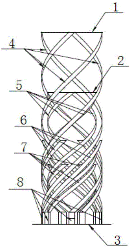
[0014] see figure 1 , a full-band navigation antenna, including antenna top loading A1, antenna top loading B2, floor 3, four antenna elements A4, four antenna elements B5, four outer antenna parasitic arms 6, four inner antenna parasitic arms 7 and four feed elements 8; each feed element 8 includes an outer arm and an inner arm, the top of the antenna element A4 is located on the lower surface of the antenna top loading A1, the bottom end of the antenna eleme...


PUM


Abstract

The invention discloses a full-band navigation antenna. The full-band navigation antenna comprises an antenna top end loading A, an antenna top end loading B, a floor, four antenna elements A, four antenna elements B, four outer side antenna parasitic arms, four inner side antenna parasitic arms and four feed elements; each feed element comprises an outer arm and an inner arm; the four feed elements are uniformly distributed on the floor; the inner arm and the outer arm of the feed element generate resonance points to generate a double-frequency effect through the outer side antenna parasitic arms and the inner side antenna parasitic arms so as to realize the widening of the bandwidth to realize circular polarization through four power-splitting couplers of a main board circuit. The full-band navigation antenna has the advantages of simple structure, reasonable design, low material cost, wide frequency band, uniform gain of each frequency point and the like; all the functions can be realized by simply pasting the common FPC on the plastic surface without using special high-frequency materials; the antenna low elevation gain is higher; and the full-band navigation antenna is still good in signals in weak-signal areas.

Description

technical field [0001] The invention relates to a satellite antenna, in particular to a full frequency band navigation antenna. Background technique [0002] The Beidou satellite navigation system is a global satellite positioning and communication system independently developed by my country. Together with the US GPS, Russia's GLONASS, and the EU's Galileo system, it is known as the world's four major satellite navigation systems. At present, the United Nations has confirmed these four systems together as the core suppliers of the global satellite navigation system. It has changed the long-term lack of high-precision and real-time positioning means in my country, broken the monopoly position of the United States and Russia in this field, and can provide a variety of business guarantees for various military and civilian uses of land, sea, air and space in my country. In particular, it is of great significance to improve the modernization of national defense in our country. ...

Claims


Application Information

Patent Timeline
Patent Type & Authority Applications(China)
IPC IPC(8): H01Q1/50
Inventor 邓飞龙
Owner SHAANXI YONGNUO INFORMATION & TECH
Learn More