
Matching method for vehicle track shielded by overpass

A technology of vehicle trajectory and matching method, applied in image data processing, instrumentation, calculation, etc., can solve problems such as blocking the continuity of vehicles, and achieve the effect of improving accuracy and stability, ensuring continuity, and solving occlusion

Active Publication Date: 2016-02-24
BEIHANG UNIV
View PDF7 Cites 11 Cited by
  • Summary
  • Abstract
  • Description
  • Claims
  • Application Information

AI Technical Summary

Problems solved by technology

However, in the urban road network, the existence of overpasses blocks the continuity of vehicle tracking in aerial video

Method used


Image

  • Matching method for vehicle track shielded by overpass
  • Matching method for vehicle track shielded by overpass
  • Matching method for vehicle track shielded by overpass

Examples


Embodiment Construction

[0041] The present invention will be further described in detail with reference to the accompanying drawings and embodiments.

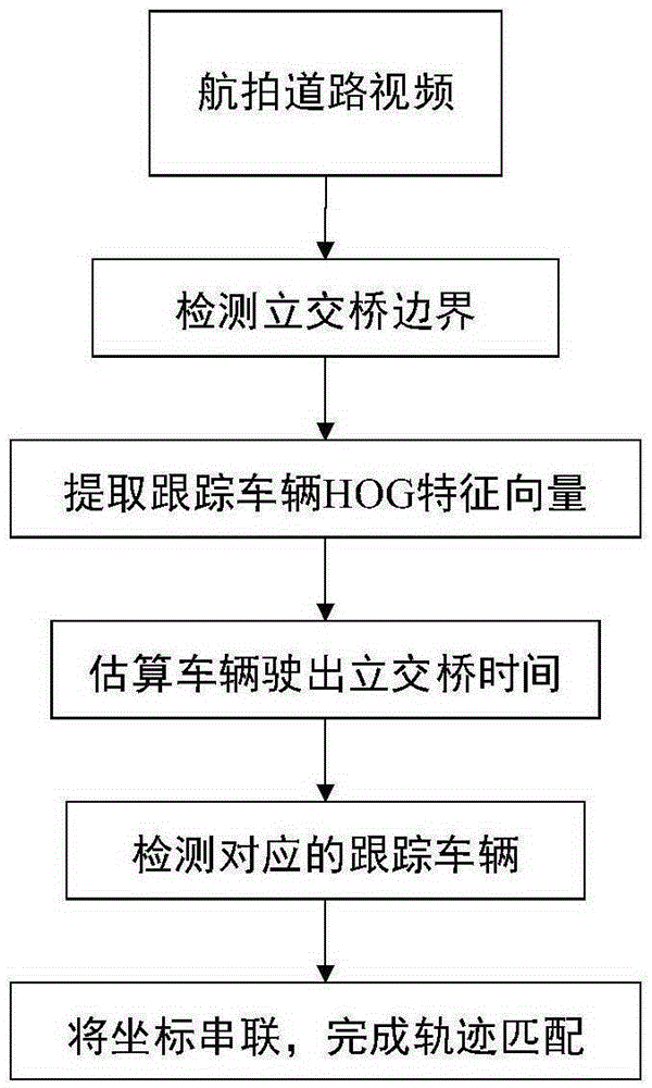
[0042] figure 1The execution flow chart of a vehicle trajectory matching algorithm with overpass occlusion for road aerial video provided by the present invention is shown. In the present invention, vehicle trajectory matching refers to connecting the coordinates of the same vehicle before entering the overpass with the coordinates exiting the overpass, so as to ensure the continuity of vehicle trajectory tracking and the correctness of traffic flow statistics. The key technology is how to accurately match the previous vehicle on the exiting side of the overpass. The invention determines the area of ​​the overpass by detecting the boundary of the overpass, and divides the image area into two parts in a targeted manner. The extracted HOG feature template is used for vehicle template matching detection in the vehicle exit area, so as to match the trac...


PUM


Abstract

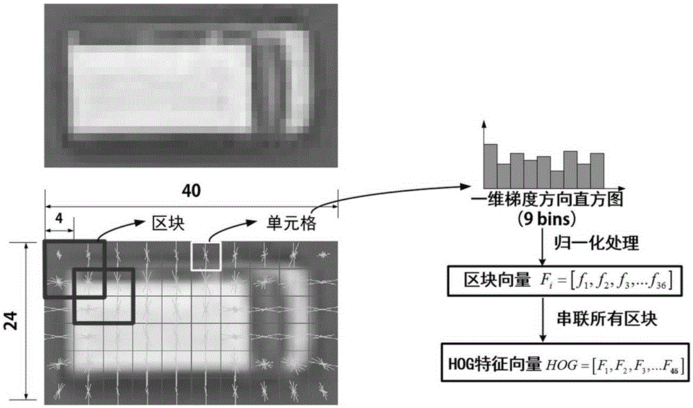
The present invention discloses a matching method for a vehicle track shielded by an overpass in an aerial video. The matching method comprises the following steps: (1) detecting the border of the overpass, confirming the area of the overpass and confirming the edge of the overpass by utilizing Sobel edge detection combined Hough Transfom; (2) extracting histogram feature in gradient orientation of a tracked vehicle as the template feature of the vehicle; (3) estimating the time interval from the moment that the vehicle comes into the overpass to the moment that the vehicle leaves the overpass according to the driving speed of the tracked vehicle; (4) detecting the corresponding tracked vehicle at the other side of the overpass. In the matching method, the leaving area of the vehicle is cleared through the detection for the area of the overpass, so as to shrink the detection range of the vehicle leaving the overpass and shorten the detection time; meanwhile, the obtained overpass width data can be used for estimating the time that the vehicle leaving the overpass.

Description

technical field [0001] The invention relates to a vehicle track matching method covered by an overpass, and belongs to the technical field of computer vision and digital image processing. Background technique [0002] In the study of urban traffic problems, road traffic flow data and vehicle spatiotemporal trajectory data are of great significance for exploring the operation rules of vehicles on urban roads and solving urban traffic problems. With the opening of UAVs in the civilian market, it is of great advantage to use UAVs to monitor the operation of urban road traffic. UAV high-altitude shooting covers a wide range, visually presenting the traffic operation status, and the collected and saved road traffic operation video is of great value for extracting vehicle spatiotemporal trajectory data. However, in urban road networks, the existence of overpasses blocks the continuity of vehicle tracking in aerial video. The vehicle disappears from the screen after driving under...

Claims


Application Information

Patent Timeline
IPC IPC(8): G06T7/00G06T7/20
CPCG06T2207/10016G06T2207/30221G06T2207/30241
Inventor 王云鹏吴新开马亚龙余贵珍徐永正
Owner BEIHANG UNIV
Learn More