
Device and method for constructing road network topology based on bus GNSS space-time tracking data

A technology of space-time trajectory and bus, applied in directions such as road network navigator, can solve problems such as inaccuracy

Active Publication Date: 2016-03-02
SHANDONG UNIV
View PDF9 Cites 42 Cited by
  • Summary
  • Abstract
  • Description
  • Claims
  • Application Information

AI Technical Summary

Problems solved by technology

The purpose of this method is only to obtain accurate positioning data, which is a data correction process, and this method assumes that the road network will not change, which is obviously inaccurate

Method used


Image

  • Device and method for constructing road network topology based on bus GNSS space-time tracking data
  • Device and method for constructing road network topology based on bus GNSS space-time tracking data
  • Device and method for constructing road network topology based on bus GNSS space-time tracking data

Examples


Embodiment 1

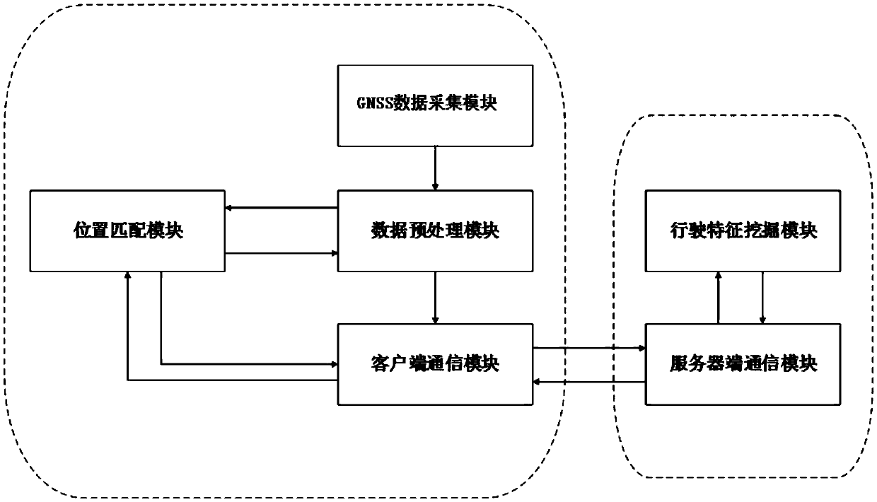
[0067]A device for constructing road network topology based on bus GNSS spatio-temporal trajectory data, including a mobile client and a server; the mobile client includes sequentially connected mobile devices with built-in GPS, data preprocessing module, position matching module and client communication module; the server includes a driving feature mining module and a server-side communication module; the driving feature mining module is provided with a mining algorithm program and a database for storing data; the client and the server communicate through GPRS. The mobile client is installed on the bus; the mobile device has a built-in GPS, which is responsible for collecting track positioning points at a certain sampling frequency and numbering them, and recording them as GNSS track data; the data preprocessing module preprocesses the GNSS track data, extracts Extract road core points when vectoring roads, and mining driving features at bus stops and traffic lights; client co...

Embodiment 2

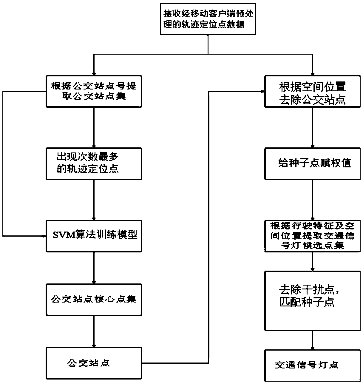
[0071] A method utilizing the device described in embodiment 1 to construct a road network topology based on GNSS spatio-temporal trajectory data, the steps are as follows:

[0072] 1) Acquisition and preprocessing of trajectory positioning points:

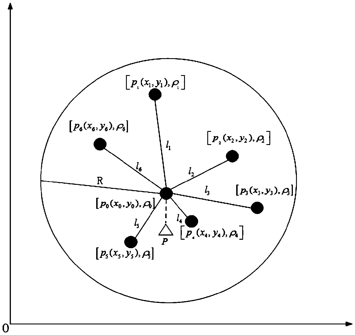
[0073] ① Install GNSS receiving equipment on the bus, collect track positioning points with a certain sampling frequency and number them; the set of track positioning points includes a bus stop set and a common point set; collect the bus stop set according to the time of acquisition The sequence numbers are 1, 2, 3...n; the points in the common point set between the bus stop set numbered 1 and the bus stop set numbered 2 are numbered 1.1, 1.2...m according to the time sequence obtained; the number is 2 The points in the common point set between the bus stop set and the bus stop set numbered 3 are numbered 2.1, 2.2...h according to the time sequence of acquisition; and so on; save and clean redundant and error data; use the histogr...

Embodiment 3

[0102] The method for constructing road network topology based on GNSS space-time trajectory data as described in embodiment 2, the difference is that, in the step 2), the specific method of adding simulation points between two road core points with missing core points is as follows: , add a simulation point at the midpoint of the line connecting two road core points with missing core points.


PUM


Abstract

The invention relates to a device and method for constructing road network topology based on bus GNSS space-time tracking data. The device comprises a mobile client and a server. The mobile client comprises a GNSS data acquisition module, a data preprocessing module, a location matching module and a client communication module which are connected in sequence. The server comprises a driving characteristic mining module and a server communication module. The driving characteristic mining module is provided with mining algorithm programs and a database for storing data. A road network map is constructed by analyzing the bus GNSS space-time tracking data, extra hardware equipment is not needed, and the device is not subjected to influence of environmental infrastructure. On-site data collection and survey by the consumption of plenty of manpower and material resources is avoided, the road network map updating cycle is shortened greatly, and further mining of traffic network information parameters and traffic situation prediction are facilitated.

Description

Technical field: [0001] The invention relates to a device and method for constructing road network topology based on bus GNSS space-time trajectory data, belonging to the technical field of data mining. Background technique: [0002] Traditional road network data acquisition methods mainly include manual field surveying and satellite remote sensing technology. Most of the location data of key points in the road network (such as bus stops and traffic lights) are usually obtained through manual field surveying and mapping. For example, traffic lights are set up by the traffic administration department, and general institutions cannot obtain their location data. Marking the location of traffic lights on the map requires repeated measurements by professionals and professional equipment, and the huge distribution network of traffic lights poses a severe test to the measurement work. In addition, although the current traffic road network map contains most of the traffic signal in...

Claims


Application Information

Patent Timeline
IPC IPC(8): G01C21/30
CPCG01C21/30
Inventor 邢建平赵庆涛张波孙晓婷孟宪鹏孟宪昊
Owner SHANDONG UNIV
Learn More