Farmland contract management ownership one-map service system and realization method thereof

A technology of service systems and management rights, applied in geographic information databases, structured data retrieval, instruments, etc., can solve the problems of insufficient spatial analysis and decision support capabilities of the system, neglecting the integrated management of spatial data and attribute data of contracted plots, etc. Achieve the effect of improving work efficiency and data quality, and improving data management and analysis

Active Publication Date: 2016-03-09
江苏金沙地理信息股份有限公司
View PDF2 Cites 16 Cited by
  • Summary
  • Abstract
  • Description
  • Claims
  • Application Information

AI Technical Summary

Problems solved by technology

[0004] The purpose of the present invention is to provide an efficient and intelligent "one map" service system of farmland contracted management rights and its realization method, which solves the problem that the existing farmland ownership data management system attaches great importance to the contracted land ownership data. The management of data ignores the integrated management of contracted land spatial data and attribute data, resulting in insufficient spatial analysis and decision-making support capabilities of the system. It can effectively improve the informatization level of data management and comprehensive business management of rural land contract management

Method used


Image

  • Farmland contract management ownership one-map service system and realization method thereof
  • Farmland contract management ownership one-map service system and realization method thereof

Examples


specific Embodiment approach

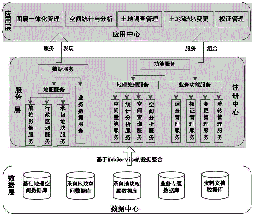
[0049] The specific implementation of the main functional modules of the "one map" service system of farmland contractual management rights is as follows:

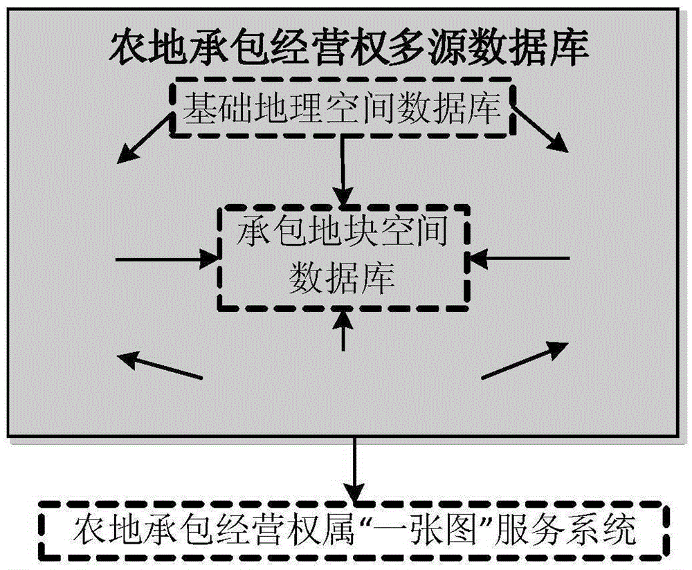
[0050] (1) The picture belongs to the integrated management module. The main functions of this module include:

[0051] a) Production of plot publicity maps: adopt the Web map printing mode under the B / S architecture, and use the map service issued by the GIS server ArcGISServer as the data source; use the query conditions constructed by inputting the query fields on the client side, call the plot search service, and locate Go to the corresponding spatial location, call the business data service at the same time, fill and display the corresponding attribute data to form the final publicity map; the output formats that can be selected include: JPG, PDF, GIF, EPS, and can dynamically input relevant titles, drawers , drawing time;

[0052] b) Integrated query of plot ownership: This query function fully realizes the associat...


PUM


Abstract

The invention discloses a farmland contract management ownership one-map service system and a realization method thereof, thereby realizing integrated processing and unified management on multisource heterogeneous data such as basic geographic data, contract block space data, contract block ownership data, service special data and file data. A Silverlight for ArcGIS API is used for realizing service integration on geoprocessing, map operation, service data management and service function operation, each type of operation is converted into a loose coupling request, needed service is queried and executed by a registration center, binding of the request operation and the service and calling of the data are realized, the contract block space positioning function is used for realizing one-map representation and analysis on the contract block ownership data, space statistics and analysis data, the service data and the like, and a new farmland contract management ownership management mode is realized. The informatization level for the rural land contract management integrated service can be enhanced, and technical supports are provided for rural land resource intelligent management and scientific decision making.

Description

technical field [0001] The present invention relates to the field of GIS, computer and spatial information services, specifically a "one map" service system and its Implementation. Background technique [0002] At present, my country's rural land still has problems such as unreal plots, unclear four-points, and inaccurate areas to varying degrees, which greatly hinders the optimal allocation of rural resource elements and seriously restricts the release of rural land values, rural economic development, and modernization of agricultural industries. . In order to rationally develop and utilize existing land resources, timely understand and master the quantity and spatial characteristics of land use changes, maintain the dynamic balance of total cultivated land and the sustainable use of land resources, and enable relevant agricultural departments to make progress in their information management, evaluation and analysis In order to improve work efficiency and management level ...

Claims


Application Information

Patent Timeline
Patent Type & Authority Applications(China)
IPC IPC(8): G06Q50/18G06Q50/26G06F17/30
CPCG06F16/29G06Q50/18G06Q50/26
Inventor 王永志康念坤刘鹏彧杨路生赵慧
Owner 江苏金沙地理信息股份有限公司
Why Eureka
Try Eureka