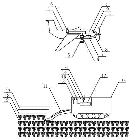
Unmanned beet harvester
A harvester and unmanned aerial vehicle technology, applied in the direction of digging harvesters, harvesters, agricultural machinery and implements, etc., can solve the problem of not being able to see the panorama of sugar beet fields, so as to improve air quality, slow down climate change, and protect ecology environmental effects
- Summary
- Abstract
- Description
- Claims
- Application Information
AI Technical Summary
Problems solved by technology
Method used
Image
Examples
Embodiment 1
[0023] A drone flying low above an unmanned beet harvester carrying out harvesting of ripe sugar beets in a field. A synthetic aperture radar is mounted on the underside of the front of the drone. The synthetic aperture radar is aimed at the unmanned beet harvester and the surrounding field. For fully automated photography work, the active microwave sensor of the synthetic aperture radar inputs the acquired aerial image information of the farmland into the electronic computer armor for storage and imaging, and the radar image is input into the flight control machine to guide the flight of the drone. The aerial image information of the farmland is input into the electronic computer B through the wireless communication device A in the UAV, radio waves and the wireless communication device B in the unmanned sugar beet harvester for storage and calculation, and the calculation results are input into the unmanned automatic driving device to control the unmanned The beet harvesting d...
Embodiment 2
[0025] A drone flying low above an unmanned beet harvester carrying out harvesting of ripe sugar beets in a field. A synthetic aperture radar is mounted on the underside of the front of the drone. The synthetic aperture radar is aimed at the unmanned beet harvester and the surrounding field. For fully automated photography work, the active microwave sensor of the synthetic aperture radar inputs the acquired aerial image information of the farmland into the electronic computer armor for storage and imaging, and the radar image is input into the flight control machine to guide the flight of the drone. The aerial image information of the farmland is input into the electronic computer B through the wireless communication device A in the UAV, radio waves and the wireless communication device B in the unmanned sugar beet harvester for storage and calculation, and the calculation results are input into the unmanned automatic driving device to control the unmanned The beet harvesting d...
PUM
 Abstract
Description
Claims
Application Information
 - R&D
- Intellectual Property
- Life Sciences
- Materials
- Tech Scout
- Unparalleled Data Quality
- Higher Quality Content
- 60% Fewer Hallucinations
Browse by: Latest US Patents, China's latest patents, Technical Efficacy Thesaurus, Application Domain, Technology Topic, Popular Technical Reports.
© 2025 PatSnap. All rights reserved.Legal|Privacy policy|Modern Slavery Act Transparency Statement|Sitemap|About US| Contact US: help@patsnap.com

