
Four-layer geographic data storage system oriented to Internet of Things application

A geographic data and storage system technology, applied in the field of the Internet of Things, can solve the problems of limited initial data extraction and query of Internet of Things devices, and cannot support complex applications, etc.

Inactive Publication Date: 2016-03-30
SHANGHAI JIAO TONG UNIV
View PDF3 Cites 4 Cited by
  • Summary
  • Abstract
  • Description
  • Claims
  • Application Information

AI Technical Summary

Problems solved by technology

However, this technology 1) is limited to the preliminary extraction and query of IoT device data, and cannot support complex applications; 2) the description of geographic location information is relatively simple; 3) the lack of support for complex data structures

Method used


Image

  • Four-layer geographic data storage system oriented to Internet of Things application
  • Four-layer geographic data storage system oriented to Internet of Things application
  • Four-layer geographic data storage system oriented to Internet of Things application

Examples


Embodiment Construction

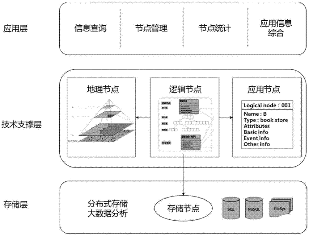
[0015] This embodiment is used and verified in the urban intelligent charging pile system. One of the main problems that needs to be solved in this system is to manage all the charging pile application data in the city, including the basic data of the charging pile itself, the event data generated by the charging behavior of electric vehicles, and some pictures and videos needed for promotional information and other types of data, corresponding to the design in the actual nodes in the framework of the present invention. From the perspective of user-oriented functions, the present invention needs to quickly recommend the nearest charging pile that meets the requirements for the user. Satisfied requirements include matching charging pile type and electric vehicle type, available state, idle state, etc., the number of idle charging piles in the same location, etc., and consider these requirements and the distance from the charging pile to recommend the most suitable charging pile...


PUM


Abstract

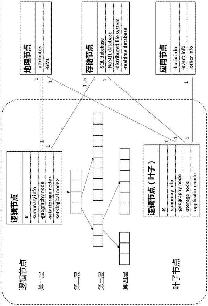
The invention discloses a four-layer geographic data storage system oriented to Internet of Things application. The system comprises a four-layer architecture composed of a geographic node, a logical node, an application node and a storage node, wherein the geographic node is used for accurately describing geometrical shape of a site in the application; the application node is used for describing objects containing geographic position information in the Internet of Things application; the logical node is a core structure of an organization space in the four-layer geographic data storage system oriented to Internet of Things application, and is used for organizing geographically significant points in a layered-structure, and respectively associating the geographic node, the application node and the storage node. A flexible and high-efficiency method is provided for query and processing operations of data; the storage node is used for efficiently processing different types of data, and needs to use SQL, NoSQL and a distributed file system in mixed form. After using the module provided in the invention, geographic data storage oriented to Internet of Things application can be organized effectively in decoupled form, and high-efficiency query and storage can be carried out.

Description

technical field [0001] The present invention relates to a technology in the field of the Internet of Things, in particular to a four-layer geographic data storage system oriented to the application of the Internet of Things. Background technique [0002] In the application of the Internet of Things, a large amount of data containing both geographical location information and text information or other information is generated. When providing services, it is necessary to consider this centralized information at the same time to provide users with accurate services based on location. Therefore, storing and processing these Data is critical in IoT applications. [0003] After searching the prior art, it was found that the scalable I 3 A quadtree space division method is proposed to organize spatial data and text data in the same storage space, and an efficient query pruning method is proposed to obtain better efficiency. I 3 The spatial organization method is strictly divided...

Claims


Application Information

Patent Timeline
Patent Type & Authority Applications(China)
IPC IPC(8): G06F17/30
CPCG06F16/9537
Inventor 栾帅蔡鸿明白吉光侯佰鑫
Owner SHANGHAI JIAO TONG UNIV
Learn More