Remote Sensing Image Classification Method Based on Hash Coding

A technology of remote sensing images and classification methods, applied in the field of remote sensing image classification based on Hash coding, can solve the problems of redundant training set information, reduce training speed, overfitting, etc., to reduce data dimensions, improve efficiency, and provide fast Effect

Active Publication Date: 2019-02-01
上海宏欣电线电缆有限公司
View PDF5 Cites 0 Cited by
  • Summary
  • Abstract
  • Description
  • Claims
  • Application Information

AI Technical Summary

Problems solved by technology

In fact, the process of labeling training samples by experts is usually done according to the visual features of the scene. Therefore, if the samples are directly handed over to experts for labeling before being screened, the consequence is that experts will spend a lot of valuable time. Fully labeling samples with similar amount of information will make the information in the training set very redundant. This redundant information will greatly reduce the training speed and even cause overfitting, especially for millions or even High-resolution images with tens of millions of pixels

Method used


Image

  • Remote Sensing Image Classification Method Based on Hash Coding
  • Remote Sensing Image Classification Method Based on Hash Coding
  • Remote Sensing Image Classification Method Based on Hash Coding

Examples


Embodiment Construction

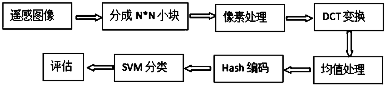
[0022] The technical scheme of the present invention is described in detail below in conjunction with accompanying drawing:

[0023] The idea of ​​the present invention is to divide each channel of the remote sensing image into N*N small blocks, (taking N=3 as an example) carry out Hash processing on each small block, generate a Hash sequence to characterize the characteristics of the block, and then encode the generated Classification improves the classification accuracy and makes the final classification result map have a better visual effect.

[0024] The basic process of the inventive method is as figure 1 As shown, it specifically includes the following steps:

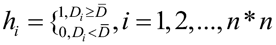
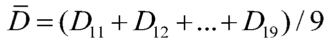
[0025] Step 1. Divide the remote sensing image into 3*3 small blocks.

[0026] For each pixel of the remote sensing image, take the pixel as the center, take the neighborhood to construct 3*3 image blocks, and obtain a set of overlapping image blocks {I 1 , I 2 ,..., I 9}

[0027] The lightness and darkness ...


PUM


Abstract

The invention discloses a remote sensing image classification method based on Hash coding. The method proposes the idea of ​​Hash automatic coding to process hyperspectral remote sensing images, divides each channel of the remote sensing image into N*N small blocks, and performs Hash on each small block. Processing, generate a Hash sequence to characterize the characteristics of the block, and then classify the generated code. Compared with the classification method based on image blocks, under the same experimental conditions, the image classification result of the method of the present invention is more accurate and the visual effect is better.

Description

technical field [0001] The invention belongs to the technical field of image information processing, and in particular relates to a remote sensing image classification method based on Hash coding. Background technique [0002] The improvement of spatial resolution and spectral resolution of satellite remote sensing system enables us to identify smaller objects from remote sensing images, such as residential buildings, commercial buildings, public transport systems and public utility equipment. A large amount of information mined from remote sensing images can be applied to fields such as disaster monitoring and assessment, urban and regional planning, and environmental monitoring. [0003] Kernel-based methods, especially support vector machines, have made a lot of progress in multispectral and hyperspectral image classification in recent years. However, like all supervised learning, the classification accuracy of support vector machines depends on the quality of the traini...

Claims


Application Information

Patent Timeline
Patent Type & Authority Patents(China)
IPC IPC(8): G06K9/62
CPCG06F18/2411
Inventor 徐军张倩杭仁龙龚磊季卫萍
Owner 上海宏欣电线电缆有限公司
Why Eureka
Try Eureka