A method for fast and high-precision non-contact surveying and mapping of ancient buildings

An ancient building, high-precision technology, applied in the field of fast and high-precision non-contact surveying and mapping of ancient buildings, can solve problems such as low precision, achieve high precision, fast speed, and meet the needs of 3D reconstruction.

Active Publication Date: 2017-10-10
GUILIN UNIV OF ELECTRONIC TECH
View PDF7 Cites 0 Cited by
  • Summary
  • Abstract
  • Description
  • Claims
  • Application Information

AI Technical Summary

Problems solved by technology

[0006] The invention provides a method for fast and high-precision non-contact surveying and mapping of ancient buildings, which solves the problem of low precision existing in existing systems or methods for surveying and mapping ancient buildings

Method used


Image

  • A method for fast and high-precision non-contact surveying and mapping of ancient buildings
  • A method for fast and high-precision non-contact surveying and mapping of ancient buildings

Examples


Embodiment Construction

[0024] The present invention will be further described below in conjunction with examples, but the present invention is not limited to these examples.

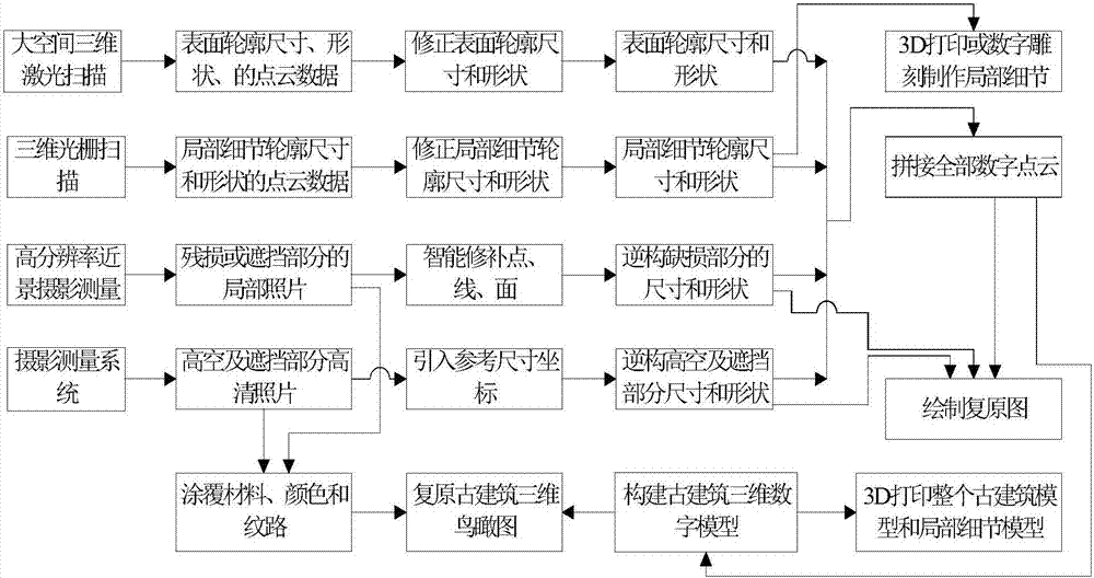
[0025] figure 1 The principle block diagram of the present invention is given, a method for rapid and high-precision non-contact surveying and mapping of ancient buildings. Different surveying and mapping methods are adopted for the surface contours, local details, damaged parts or occluded parts, and high-altitude parts or occluded parts of ancient buildings.

[0026] For the surface contours of ancient buildings, use a large-space 3D laser scanner to scan to obtain their point cloud data and panoramic images. Each point cloud data has a relative coordinate, and the obtained point cloud data is unified into the same coordinate system. Then build a three-dimensional model of the ancient building, measure and map the surface contour size with high precision, and correct the size and shape of the ancient building surface contour...


PUM


Abstract

The invention discloses a method for quickly surveying and mapping a historic building in a high-accuracy non-contact mode. Point cloud data and a panorama image of the surface profile of the historic building are obtained by utilizing a large-space three-dimensional laser scanner to establish a stereoscopic model of the historic building, fine point cloud data of local details of the historic building is obtained by utilizing a three-dimensional grating scanner, and the sizes and shapes of the surface profile and the local details of the historic building are corrected by combining with a building construction method and construction module; digital information of the damaged parts or blocked parts of the historic building is acquired by utilizing a high-resolution camera, and the sizes and shapes of the parts are back-formed; the point, line and plane characteristics of the high-altitude parts or the blocked parts are acquired by utilizing the high-resolution camera, and the sizes and shapes of the parts are back-formed; all measured blocked data is unified to the same coordinate system and all digital point cloud information of the historic building is spliced to draw a restored image of the historic building and establish a stereoscopic digital model of the historic building, and a three-dimensional aerial view of the historic building is restored by combining with coating materials, colors and lines of the historic building.

Description

technical field [0001] The invention relates to a method for surveying and mapping ancient buildings, in particular to a method for rapid and high-precision non-contact surveying and mapping of ancient buildings. Background technique [0002] Ancient buildings are the crystallization of wisdom and the product of practical activities of ancient people. They carry rich information about history, culture and art, and are important physical materials for studying their period. Ancient buildings are precious material cultural heritage, which are non-renewable, and once destroyed, it will cause heavy losses. By surveying and mapping complete and real electronic documents such as floor plans, elevations, and section drawings of ancient buildings, it can provide accurate scientific basis for the research, restoration, and reconstruction of ancient buildings. [0003] Traditional building surveying and mapping methods use manual measurement and manual drawing. The measuring tools in...

Claims


Application Information

Patent Timeline
Patent Type & Authority Patents(China)
IPC IPC(8): G01C11/00G01C15/00
CPCG01C11/00G01C15/002
Inventor 孙保燕周贤君翁裕育程昂张惊涛
Owner GUILIN UNIV OF ELECTRONIC TECH
Why Eureka
Try Eureka