Individual geological disaster emergency investigation method based on remote sensing of small unmanned aerial vehicle

A technology of geological disasters and machine-based remote sensing, which is applied in the interpretation of photos, radio wave measurement systems, satellite radio beacon positioning systems, etc., and can solve problems such as limited applications

Inactive Publication Date: 2016-08-17
CHINA THREE GORGES UNIV
View PDF4 Cites 45 Cited by
  • Summary
  • Abstract
  • Description
  • Claims
  • Application Information

AI Technical Summary

Problems solved by technology

However, at present, an effective method system has not been established for the emergency investigation of single

Method used


Image

  • Individual geological disaster emergency investigation method based on remote sensing of small unmanned aerial vehicle
  • Individual geological disaster emergency investigation method based on remote sensing of small unmanned aerial vehicle
  • Individual geological disaster emergency investigation method based on remote sensing of small unmanned aerial vehicle

Examples


Embodiment Construction

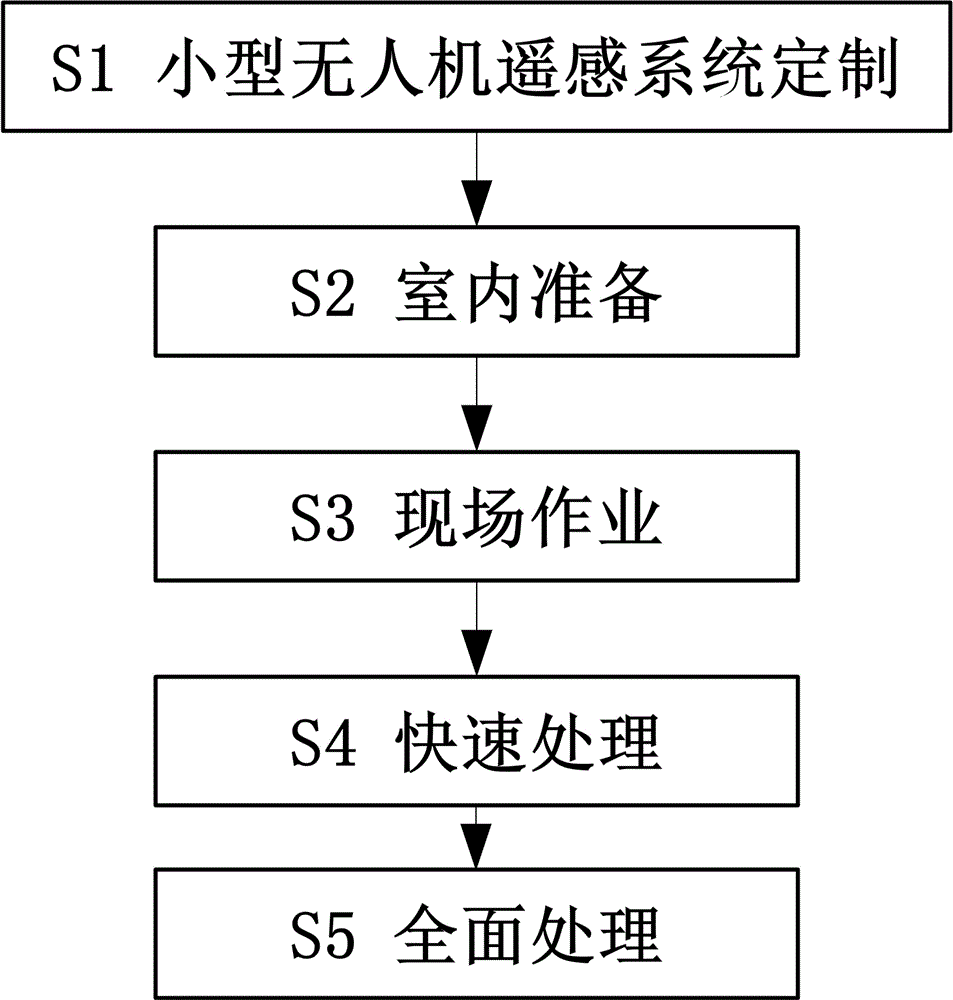
[0049] The technical solution of the present invention will be further described in conjunction with the accompanying drawings. Such as figure 1 As shown, a single geological disaster emergency investigation method based on small UAV remote sensing according to the present invention, the technical steps include: small UAV remote sensing system customization S1; indoor preparation S2; on-site operation S3; rapid processing S4; Handle the S5 across the board.

[0050] S1. Customization of small UAV remote sensing system

[0051] Considering that the vast majority of individual geological disasters are small in scale, they are often located on the slopes of valleys with large terrain elevation differences, the human eye has limited visibility, local weather conditions change rapidly (such as wind force and direction), or they are located on major traffic roads. Or crowded places (such as tourist attractions), there are often high-altitude facilities such as communications and e...


PUM


Abstract

The invention relates to an emergency investigation method for a single geological disaster based on remote sensing of a small unmanned aerial vehicle. The technical steps include: customization of small UAV remote sensing system; indoor preparation; field operation; rapid processing; comprehensive processing. The purpose is to carry out fast and effective image control point layout and measurement based on slope characteristics, and at the same time use a small unmanned aerial vehicle remote sensing system to automatically collect photos of the slope, and generate the slope by introducing image control points in the process of digital photogrammetry. The high-precision and high-resolution remote sensing results are obtained, and then the slope deformation detection and calculation are carried out on the two-phase remote sensing results that have passed the precision inspection and high-precision registration, so as to obtain the overall deformation characteristics of the slope quickly, efficiently and accurately.

Description

technical field [0001] The invention relates to a geological disaster emergency investigation method, in particular to a single geological disaster emergency investigation method based on remote sensing of a small unmanned aerial vehicle. Background technique [0002] Emergency investigation is the primary and basic link in emergency response to geological disasters. It provides a scientific basis for emergency response to geological disasters by quickly ascertaining the geological structure and environmental conditions of geological hazards. Provide as accurate, complete and detailed relevant information as possible in a short period of time to scientifically determine the disaster reduction plan. [0003] UAV remote sensing technology has begun to be widely used in emergency investigations of geological disasters, but at present it is still mainly focused on emergency investigations and disaster loss assessments of large-scale geological disasters after major natural disas...

Claims


Application Information

Patent Timeline
IPC IPC(8): G01C15/00G01C15/02G01S19/14G01C11/04G01V8/10
CPCG01C15/00G01C11/04G01C15/02G01S19/14G01V8/10
Inventor 黄海峰易武林海玉王焕易庆林张国栋李剑南张磊胡乃利吕奕铭柳青雷德鑫童时岸刘凯
Owner CHINA THREE GORGES UNIV
Why Eureka
Try Eureka