Method and device for measuring spatial distribution of crop plant heights through unmanned plane remote sensing

A space distribution, machine-based remote sensing technology, applied in image analysis, image data processing, instruments, etc., can solve the problems of inconsistent data accuracy, reduce ground survey work, and large human subjective influence, so as to ensure accuracy and consistency, reduce ground Measuring the effect of work

Inactive Publication Date: 2016-08-17
BEIJING RES CENT FOR INFORMATION TECH & AGRI
View PDF3 Cites 12 Cited by
  • Summary
  • Abstract
  • Description
  • Claims
  • Application Information

AI Technical Summary

Problems solved by technology

[0005] Aiming at the deficiencies in the prior art, the present invention provides a method and device for measuring the spatial distribution of crop height by remote sensing of UAV, which uses the maneuverability and flexibility of UAV remote sensing to obtain the space of plant height in crop coverage areas under large-scale

Method used


Image

  • Method and device for measuring spatial distribution of crop plant heights through unmanned plane remote sensing
  • Method and device for measuring spatial distribution of crop plant heights through unmanned plane remote sensing
  • Method and device for measuring spatial distribution of crop plant heights through unmanned plane remote sensing

Examples


Example Embodiment

[0059] In order to make the objectives, technical solutions, and advantages of the embodiments of the present invention clearer, the technical solutions in the embodiments of the present invention will be described clearly and completely in conjunction with the accompanying drawings in the embodiments of the present invention. Obviously, the described embodiments It is a part of the embodiments of the present invention, not all of the embodiments. Based on the embodiments of the present invention, all other embodiments obtained by those of ordinary skill in the art without creative work belong to the protection of the present invention. range.

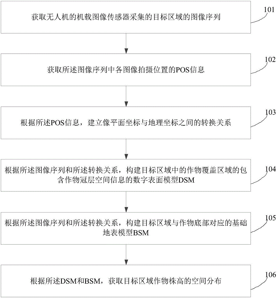
[0060] figure 1 It shows a schematic flow chart of a method for measuring the spatial distribution of crop height by drone remote sensing according to an embodiment of the present invention, such as figure 1 As shown, the method for measuring the spatial distribution of crop height by drone remote sensing in this embodiment includes:

[006...


PUM


Abstract

The invention provides a method and device for measuring the spatial distribution of crop plant heights through unmanned plane remote sensing, and the method comprises the steps: obtaining an image sequence, collected by an airborne image sensor of an unmanned plane, of a target region; obtaining the POS information of photographing positions of all images in the image sequence; building a conversion relation between the image plane coordinates and physical coordinates according to the POS information; respectively building a DSM (digital surface model), comprising crop canopy information, of a crop coverage region in the target region and a BSM (basic surface model), corresponding to the bottom of crops, of the target region according to the image sequence and the conversion relation; and obtaining the spatial distribution of the crop plant heights in the target region according to the DSM and BSM. The method can obtain the large-area crop plant heights of a crop region under the condition of complex farmlands through employing the flexible maneuvering characteristics of unmanned plane remote sensing, and can solve problems that manual observation takes points as a plane, consumes a large amount of manpower and a large number of material resources, is severely affected by the subjectivity of a person, and is not consistent in data precision.

Description

technical field [0001] The invention relates to the technical field of UAV remote sensing measurement and image processing, in particular to a method and device for UAV remote sensing measurement of crop height spatial distribution. Background technique [0002] Crop height is an important agronomic parameter that characterizes different crop varieties. In field agricultural production, the difference in plant height of the same crop variety will directly affect the final yield. The main reason is that plant height is closely related to crop aboveground biomass, and aboveground biomass is related to yield, so plant height is usually an important agronomic parameter to measure crop growth. In addition, when floods and wind disasters occur in farmland crops, there will be a large number of crops lodging, and the lodging degree and spatial distribution are complex, so it is difficult to observe all the lodging in place through manual observation when carrying out lodging invest...

Claims


Application Information

Patent Timeline
IPC IPC(8): G06T7/00
CPCG06T7/0002G06T2207/10032G06T2207/30188
Inventor 杨贵军徐波于海洋冯海宽杨小冬赵晓庆
Owner BEIJING RES CENT FOR INFORMATION TECH & AGRI
Why Eureka
Try Eureka