A Positioning and Orientation Method Based on Dual Magnetic Beacons

A positioning and beaconing technology, applied in ground navigation and other directions, can solve problems such as unsuitable for single use, poor navigation and positioning accuracy, complex environment, etc., to avoid significant attenuation of signal strength, improve speed and accuracy, and signal penetration strong effect

Inactive Publication Date: 2018-11-23
HARBIN INST OF TECH
View PDF5 Cites 0 Cited by
  • Summary
  • Abstract
  • Description
  • Claims
  • Application Information

AI Technical Summary

Problems solved by technology

Outdoors, with the improvement and popularization of satellite navigation systems such as GPS and Beidou, positioning accuracy services have basically met people's daily needs; The accuracy is very poor, and even the positioning cannot be completed
The complex indoor environment brings great difficulties to navigation and positioning
[0003] At present, the indoor navigation and positioning methods mainly include the following types: 1. Positioning technology based on wireless networks (WiFi, RFID, Bluetooth, etc.), which mainly uses the received signal strength index (RSSI) for ranging and positioning. When there are obstacles at the receiving end and the receiving end, the signal strength will be greatly attenuated due to thick wooden boards and cement walls in the room, which will cause the signal at the receiving end to be unstable, resulting in poor navigation and positioning accuracy
2. The positioning method based on visible light, which cannot realize navigation and positioning in the environment where there is occlusion or light cannot reach, has great limitations
3. A positioning method based on geomagnetic signals. This method mainly uses indoor geomagnetic field information to achieve navigation and positioning. However, the indoor environment is relatively complex, especially the existence of magnetic materials such as steel bars in the wall and the existence of many electronic devices, which have an impact on geomagnetic signals. Larger, unable to achieve precise positioning
4. The method based on the inertial navigation system, although this method can provide accurate navigation and positioning information in a short period of time, due to its accumulated error, the error will become larger and larger with time, so it is not suitable for single use

Method used


Image

  • A Positioning and Orientation Method Based on Dual Magnetic Beacons
  • A Positioning and Orientation Method Based on Dual Magnetic Beacons
  • A Positioning and Orientation Method Based on Dual Magnetic Beacons

Examples


Embodiment 1

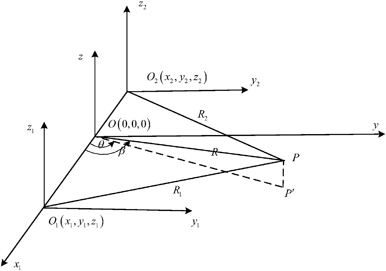
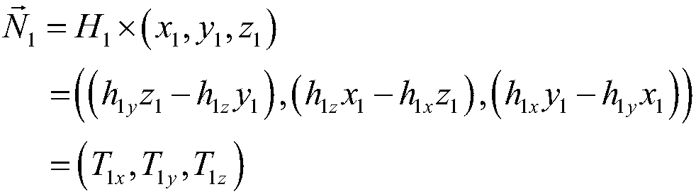
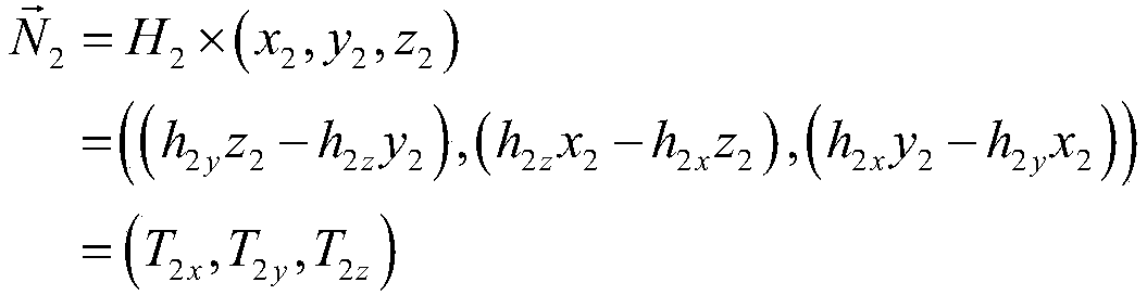
[0057] Embodiment 1: Verify the positioning accuracy of the dual-beacon positioning system, where there is an obstacle with an attenuation coefficient of 0.91 between the magnetic field of beacon 1 and the target, compare this embodiment with the method of determining the position according to the magnetic field strength:

[0058] First set the output frequency of the two magnetic beacons, the x-axis frequency in magnetic beacon 1 is f 1 =2Hz, y-axis frequency is f 2 = 5Hz, the x-axis frequency in Magnetic Beacon 2 is f 3 =7Hz, y-axis frequency is f 4 =9Hz, the initial positions of the two magnetic beacons in the whole coordinate system (p 1x ,p 1y ,p 1z )=(100,0,0), (p 2x ,p 2y ,p 2z )=(-100,0,0), the target location is (15,60,10).

[0059] Extract n=100 sampling data with f=100Hz as the sampling frequency on the magnetometer installed on the target to be positioned again, denoted as H i , i=1, 2...100; calculate according to steps 3 to 5 in the above embodiment, the...


PUM


Abstract

The invention provides a positioning and orientation method based on double magnetic beacons. Two magnetic beacons which are mutually perpendicular and are prepared by two sets of solenoids with known coil diameters, winding numbers, and electric currents are used, two magnetic beacons are installed on a known position as a signal source, a magnetometer is installed on a positioned target, and the magnetometer is used for real time measurement of data; output frequencies of the two magnetic beacons are set, in the magnetic beacon 1, x axis frequency is f1 and y axis frequency is f2, in the magnetic beacon 2, x axis frequency is f3 and y axis frequency is f4, and the two magnetic beacons are in initial positions of a whole coordinate system; n data are extracted from the magnetometer installed on target to be positioned by using a sample frequency which is more than twice the maximum frequency of the magnetic beacons; Fourier decomposition is carried out for acquired data, two groups of signals which are corresponding to frequencies of the two magnetic beacons are obtained respectively, the target is determined according to H1, H2, H3 and H4, and direction vectors of a position of the garget are determined: the position of the target is determined according to the two direction vectors, and the two direction vectors can be used for determining two straight lines.

Description

technical field [0001] The invention relates to a positioning and orientation method based on a dual magnetic beacon, and belongs to the technical field of positioning and orientation methods. Background technique [0002] With the development of technology, people's demand for location-based services is also increasing. Outdoors, with the improvement and popularization of satellite navigation systems such as GPS and Beidou, positioning accuracy services have basically met people's daily needs; The accuracy is so poor that it can't even complete the positioning. The complex indoor environment brings great difficulties to navigation and positioning. [0003] At present, the indoor navigation and positioning methods mainly include the following types: 1. Positioning technology based on wireless networks (WiFi, RFID, Bluetooth, etc.), which mainly uses the received signal strength index (RSSI) for ranging and positioning. When there are obstacles at the receiving end and the...

Claims


Application Information

Patent Timeline
Patent Type & Authority Patents(China)
IPC IPC(8): G01C21/04
CPCG01C21/04
Inventor 李清华郑元勋解伟男张大成刘元
Owner HARBIN INST OF TECH
Why Eureka
Try Eureka