
Physical model testing system and method for landform evolution of tidal flat-tidal creek system

A physical model and test system technology, applied in soil material testing, material inspection products, etc., can solve problems such as the inability to truly simulate the evolution of coastal tidal flat-tidal trench landforms, etc. Effect

Active Publication Date: 2016-10-12
HOHAI UNIV
View PDF4 Cites 16 Cited by
  • Summary
  • Abstract
  • Description
  • Claims
  • Application Information

AI Technical Summary

Problems solved by technology

[0004] The technical problem to be solved by the present invention is to provide a physical model test system and method for tidal flat-tidal trench system landform evolution in view of the above-mentioned deficiencies in the background technology, which can truly simulate the coastal tidal flat-tidal trench landform evolution process and solve the problem of Conventional water-sediment physical model tests are still unable to truly simulate the technical problem of the tidal flat-tidal trench landform evolution process in the coastal zone

Method used

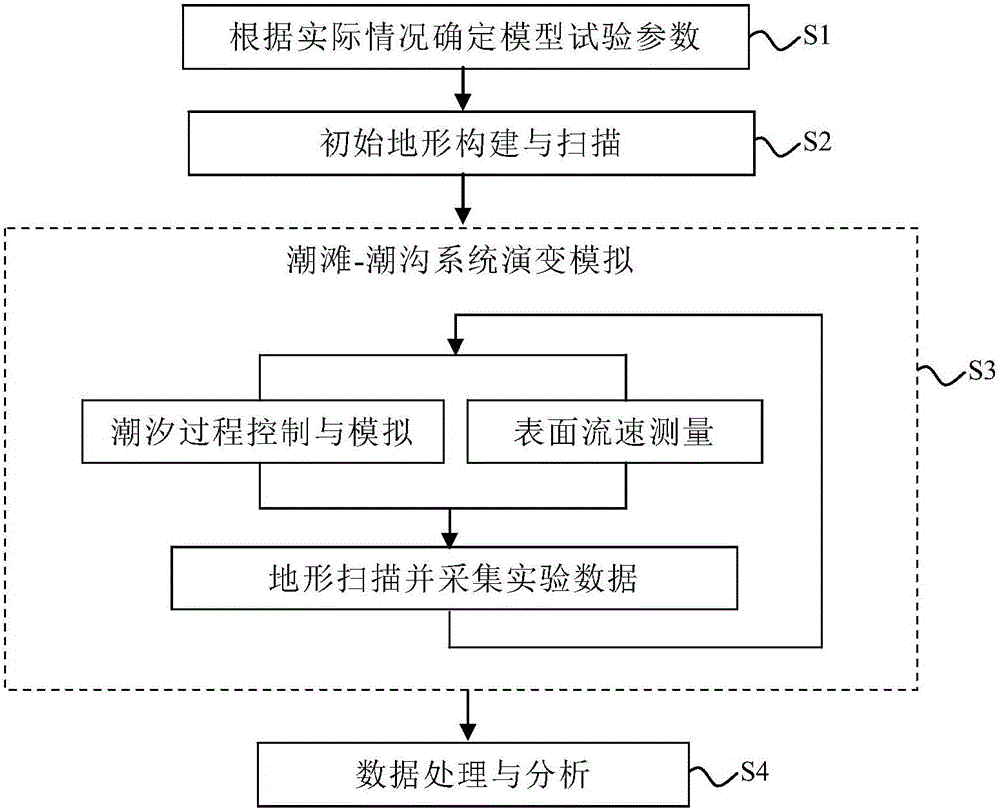
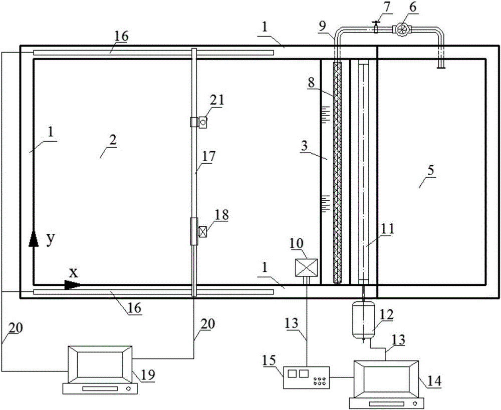
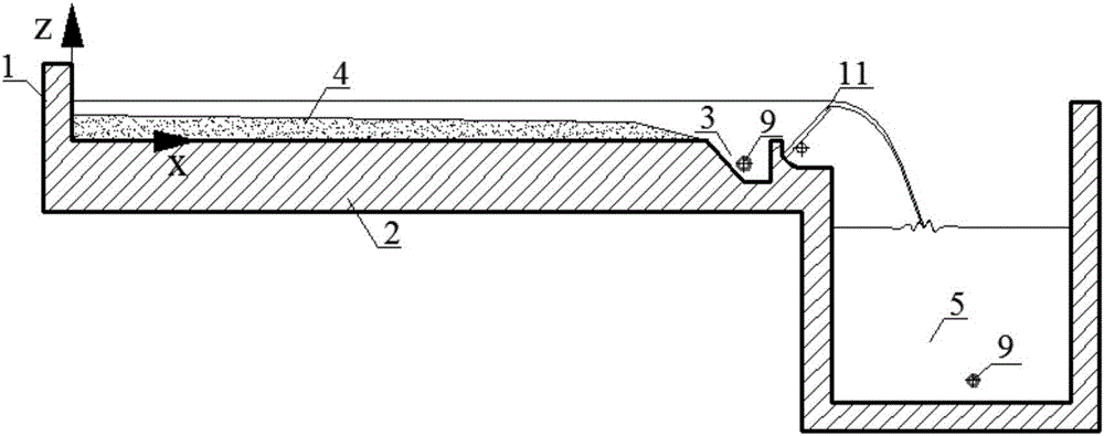

Image

  • Physical model testing system and method for landform evolution of tidal flat-tidal creek system
  • Physical model testing system and method for landform evolution of tidal flat-tidal creek system
  • Physical model testing system and method for landform evolution of tidal flat-tidal creek system

Examples


Embodiment

[0058] Example: Taking the muddy tidal flat-tidal trench system physical model test on the coast of central Jiangsu as an example, the central coast of Jiangsu is a typical silt muddy tidal flat with an intertidal width of about 7-10 km and an average slope of 0.1 % to 1%, the sediments are mainly silt and silt with a particle size of 0.001-0.05mm, and the sediments on the beach surface are obviously zonal, and the median particle size gradually increases from land to sea, respectively 28.2 μm and 40.0 μm , 87.7μm, the tidal flat particle size in the research area is calculated as follows: d 95 = 0.1300mm, d 50 = 0.0295mm, d 5 =0.0014mm, get the sediment particle density ρ by hydrometer method s =2670kg / m 3- . The tidal flat-tidal trench system is an intertidal landform formed by fine-grained sediment under the hydrodynamic conditions dominated by tidal currents, and its cross-sectional shape is mainly controlled by sediment supply and hydrodynamic conditions. This experi...


PUM

PropertyMeasurementUnit
Densityaaaaaaaaaa
Average densityaaaaaaaaaa
Median particle sizeaaaaaaaaaa

Abstract

The invention discloses a physical model testing system and method for landform evolution of a tidal flat-tidal creek system, and belongs to the technical field of landform evolution tests of the tidal flat-tidal creek system. A physical model comprises a tidal flat-tidal creek simulation area, a water circulation system, a water level measurement and control system and a microrelief laser scanner, and can realistically simulate a tidal flat-tidal creek landform evolution process of a coastal zone. The development and evolution rules of the tidal flat-tidal creek system and the change rules of the flow velocity with the water depth are obtained by acquiring tidal flat-tidal creek topographic data of all testing stages, a preset water level process and an actual water level process of a tidal flat-tidal creek simulation zone and trace particle movement images recorded by a camera in a testing process.

Description

technical field [0001] The invention discloses a tidal flat-tidal trench system landform evolution physical model test system and method, belonging to the technical field of tidal flat-tidal trench system landform evolution test. Background technique [0002] Tidal flats are widely distributed in the coastal areas of China. Taking the silty muddy tidal flats along the coast of Jiangsu as an example, the intertidal zone is 6-8 kilometers wide and the slope is extremely gentle, only about 0.1%. Silt dominated. There are often tidal trench systems developed on the tidal flats, and the tidal trenches have the characteristics of fast change speed and large swing range. With the construction of coastal projects such as coastal reclamation and ports, the influence of tidal trench system on the safety of coastal engineering buildings has attracted more and more attention. At the same time, the tidal flat-tidal trench system is an important habitat for birds and marine life. , the ...

Claims


Application Information

Patent Timeline
IPC IPC(8): G01N33/24
CPCG01N33/24
Inventor 龚政耿亮吕亭豫严佳伟徐贝贝周曾王韫玮李欢蔡辉张长宽
Owner HOHAI UNIV
Learn More