
Binocular vision based UAV (Unmanned Aerial Vehicle) danger vehicle distance identifying system and method

A recognition system, binocular vision technology, applied in radio wave measurement system, satellite radio beacon positioning system, use of re-radiation and other directions, can solve early warning and feedback, law enforcement agencies do not have detailed credentials, can not real-time distance between two vehicles and other problems, to achieve the effect of improving traffic intelligence and reducing work intensity

Inactive Publication Date: 2016-10-12
江志奇
View PDF5 Cites 20 Cited by
  • Summary
  • Abstract
  • Description
  • Claims
  • Application Information

AI Technical Summary

Problems solved by technology

[0002] With the development of social economy and the improvement of people's living standards, the number of vehicles has increased sharply, followed by more and more traffic accidents such as rear-end collisions, due to the lag of information transmission, congestion caused by traffic accidents, etc. Often the law enforcement agencies do not have detailed evidence to understand the entire process of the accident
[0003] At present, there are various methods, devices and systems for measuring the safe distance between vehicles, but most of these are used to assist driving, and cannot provide real-time early warning of the distance between two vehicles and feedback to law enforcement agencies

Method used


Image

  • Binocular vision based UAV (Unmanned Aerial Vehicle) danger vehicle distance identifying system and method
  • Binocular vision based UAV (Unmanned Aerial Vehicle) danger vehicle distance identifying system and method
  • Binocular vision based UAV (Unmanned Aerial Vehicle) danger vehicle distance identifying system and method

Examples


Embodiment Construction

[0017] In order to make the object, technical solution and advantages of the present invention clearer, the present invention will be further described in detail below in conjunction with the accompanying drawings.

[0018] The present invention is a binocular vision-based UAV dangerous vehicle distance identification system and method, equipped with a GPS module, a wireless transmission module and an airborne camera, using binocular ranging and three-dimensional reconstruction technology combined with GPS positioning technology to achieve ranging and Speed ​​measurement and vehicle hazard warning.

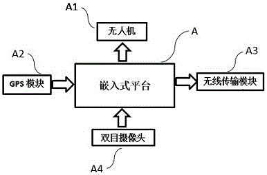
[0019] Such as figure 1 As shown, a warning system based on binocular vision for the dangerous vehicle distance of UAVs includes embedded platform A, UAV A1, GPS module A2, wireless transmission module A3, and binocular camera A4. Among them, the embedded platform A should use the minnowboardturbot high-performance computing platform to control the flight attitude of the UAV A1 a...


PUM


Abstract

The invention relates to a binocular vision based UAV danger vehicle distance identifying system and method. The system is provided with a GPS module a wireless transmission module and an airborne camera, and a binocular range finding and 3D reconstruction technology is combined with a GPS positioning technology to realize range finding, speed measurement as well as vehicle danger early-warning. The distance and speed of a vehicle are measured by calibrating the camera, obtaining a target image, extracting features, stereoscopic correction, stereoscopic matching, and measuring distance and speed. After that it is determined that two vehicles are in danger distance, a video captured by the camera is sent to a traffic management department in real time via the wireless transmission module. According to the invention, work is high-efficiency and accurate, the traffic intelligent degree is greatly improved, and work intensity of the traffic management department is reduced.

Description

technical field [0001] The invention relates to the field of dangerous vehicle distance recognition, in particular to a binocular vision-based UAV dangerous vehicle distance recognition system and method. Background technique [0002] With the development of social economy and the improvement of people's living standards, the number of vehicles has increased sharply, followed by more and more traffic accidents such as rear-end collisions, due to the lag of information transmission, congestion caused by traffic accidents, etc. Often the law enforcement agencies have no detailed evidence to understand the whole process of the accident. [0003] At present, there are various methods, devices and systems for measuring the safe inter-vehicle distance, but these are mostly used for driving assistance, and cannot provide real-time early warning of the inter-vehicle distance and feedback to law enforcement agencies. Therefore, there is an urgent need for a system to assist the law ...

Claims


Application Information

Patent Timeline
Patent Type & Authority Applications(China)
IPC IPC(8): G01S11/12G01S19/52G01S19/48
CPCG01S11/12G01S19/48G01S19/52
Inventor 李彦玮江志奇刘怡萱谷亚茹廖羽乔
Owner 江志奇
Learn More