Data fusion-based atmospheric particulate matter remote sensing monitoring method

A technology for atmospheric particulate matter and remote sensing monitoring, which is applied in particle suspension analysis, measuring devices, and re-radiation of electromagnetic waves. The effect of improving accuracy

Inactive Publication Date: 2016-11-16
MAPUNI TECH CO LTD
View PDF6 Cites 35 Cited by
  • Summary
  • Abstract
  • Description
  • Claims
  • Application Information

AI Technical Summary

Problems solved by technology

[0004] Due to the satellite orbit interval, cloud coverage and the limitations of the dark target inversion algorithm itself, the spatial coverage of remote sensing image inversion particulate matter products is low and there is a large-scale lack of data, which is difficult to be a good fusion data source. However, its application in air quality monitoring and other fields is limited

Method used


Image

  • Data fusion-based atmospheric particulate matter remote sensing monitoring method
  • Data fusion-based atmospheric particulate matter remote sensing monitoring method
  • Data fusion-based atmospheric particulate matter remote sensing monitoring method

Examples


specific Embodiment

[0080] The implementation process of the remote sensing monitoring method for atmospheric particulate matter based on data fusion provided by the embodiment of the present invention will be described below in conjunction with a practical case:

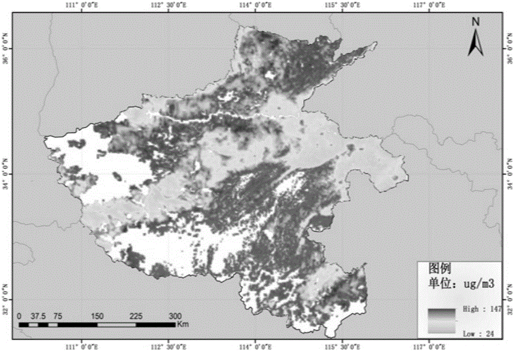
[0081] 1. Inversion of satellite remote sensing data. The study used the MODIS satellite image data on May 5, 2016 to carry out aerosol remote sensing inversion, and used the boundary layer height and humidity to perform vertical correction and humidity correction. Determine the mass concentration of particulate matter near the ground, and obtain the PM2.5 remote sensing inversion monitoring map based on MODIS, as shown in figure 2 shown.

[0082] from figure 2 It can be seen that the white area is the space of missing data, so the spatial coverage of satellite remote sensing retrieval data is low, which is not conducive to accurate air quality forecasting.

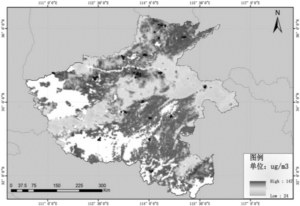
[0083] 2. Integration of ground measured data and satellite remote sensi...


PUM


Abstract

The invention discloses a remote sensing monitoring method for atmospheric particles based on data fusion, and relates to the technical field of air quality monitoring. This method fuses satellite remote sensing retrieval data and ground monitoring data, and interpolates the fused results to obtain particle concentration data with complete spatial coverage, which effectively solves the problems caused by weather, satellite orbital interval, and cloud coverage. And the lack of particle concentration data caused by the limitations of the dark target inversion algorithm itself greatly improves the accuracy of air quality monitoring.

Description

technical field [0001] The invention relates to the technical field of air quality monitoring, in particular to a remote sensing monitoring method for atmospheric particles based on data fusion. Background technique [0002] The main purpose of data fusion is to extract more and more valuable information from multi-source data than the original single-source data, and to improve and improve the performance indicators of the original data in some aspects. For remote sensing monitoring of particulate matter, the purpose of fusion is to maximize the spatial coverage of particulate matter data on the basis of ensuring its original spatial resolution, and provide timely and effective particulate matter products for air quality research. [0003] At present, data fusion is mainly carried out by using MODIS, HJ, FY and other image retrieval data obtained from remote sensing monitoring of atmospheric particulate matter. However, this data fusion method has the following defects: ...

Claims


Application Information

Patent Timeline
Patent Type & Authority Applications(China)
IPC IPC(8): G01N15/06G01S17/88
CPCG01N15/06G01S17/88
Inventor 刘锐谢涛陈静陈贝贝盛琳
Owner MAPUNI TECH CO LTD
Why Eureka
Try Eureka