High-precision baseline resolving method by use of multisystem GNSS observed values

A baseline solution and observation technology, applied in the field of satellite navigation, can solve problems such as inability to fix ambiguities, complex baseline solution models, and limited multi-system advantages

Active Publication Date: 2016-11-16
WUHAN UNIV
View PDF4 Cites 13 Cited by
  • Summary
  • Abstract
  • Description
  • Claims
  • Application Information

AI Technical Summary

Problems solved by technology

When using multi-system GNSS data for baseline calculation, the influence of inter-system deviation and inter-frequency deviation must be taken into account, which makes the baseline calculation model more complicated, and because the frequencies of different systems are generally inconsistent, resulting in double-difference ambiguity between different systems The ambiguity does not have the characteristics of the whole cycle, and the ambiguity cannot be fixed directly.
The above problems seriously limit the full play of the advantages of multi-system

Method used


Image

  • High-precision baseline resolving method by use of multisystem GNSS observed values
  • High-precision baseline resolving method by use of multisystem GNSS observed values
  • High-precision baseline resolving method by use of multisystem GNSS observed values

Examples


Embodiment Construction

[0041] In order to facilitate those of ordinary skill in the art to understand and implement the present invention, the present invention will be described in further detail below in conjunction with the accompanying drawings and embodiments. It should be understood that the implementation examples described here are only used to illustrate and explain the present invention, and are not intended to limit this invention.

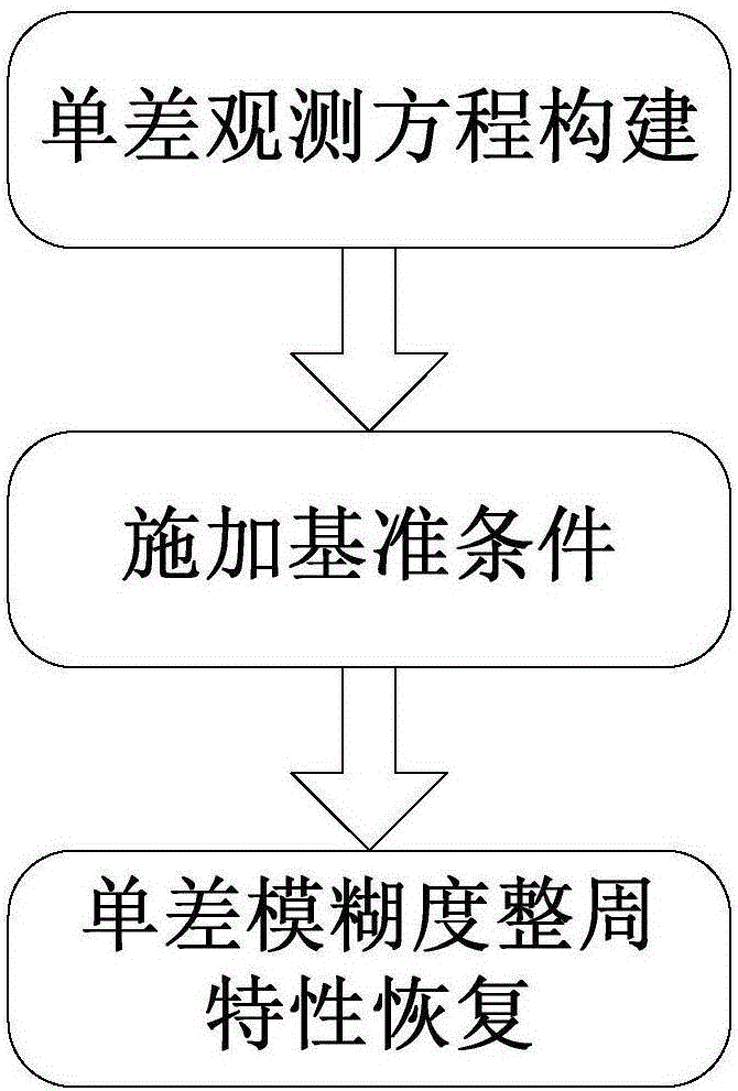
[0042] please see figure 1 , a kind of high-precision baseline solution method utilizing multi-system GNSS observation value of the present invention, comprises the following steps:

[0043] (1) Constructing single-difference observations between stations;

[0044]The pseudorange and carrier phase observations of each frequency of each GNSS system are used to make differences between the stations at both ends of the baseline to form a single-difference observation between stations. The inter-station single-difference observation equation can be expressed as...


PUM


Abstract

The invention discloses a high-precision baseline resolving method by use of multisystem GNSS observed values. First of all, inter-station single-difference observed values are constructed by performing subtraction between stations at the two sides of a baseline on a pseudo range and a carrier wave phase observed value of each frequency of each GNSS system, afterwards, the rank defect problem of a normal equation is solved by taking a pseudo range hardware delay of a certain type of observed values as a reference, influences of a combined UPD are removed by performing estimation processing on floating point single-difference fuzziness according to the property of each GNSS system, an integer cycle characteristic of the single-difference fuzziness is recovered, and thus high-precision resolving of the baseline is realized. According to the invention, the defects existing in a conventional multisystem GNSS baseline resolving method are solved, and the method has the advantages of rigorous theory, simple model, easy realization, high expandability, high precision and the like, thereby being applied to multiple fields such as geological disaster monitoring, structure object deformation monitoring, precision navigation and the like.

Description

technical field [0001] The invention belongs to the technical field of satellite navigation, and in particular relates to a method for calculating a high-precision baseline by using observation data of multiple global navigation satellite systems (Global Navigation Satellite System, GNSS). Background technique [0002] In view of the great advantages of GPS (Global Positioning System) in the military and civilian fields, many countries and organizations in the world have begun to build independent global navigation satellite systems. The GNSSs that have been built or are under construction include GPS in the United States, GLONASS (GLObalnaya NAvigatsionnaya Sputnikovaya Sistema) in Russia, Galileo in the European Union and BDS (BeiDou Navigation Satellite System) in China. A large number of studies have shown that comprehensively utilizing the signals of multiple GNSS systems and uniformly processing the observation data of different systems at the observation value level c...

Claims


Application Information

Patent Timeline
Patent Type & Authority Applications(China)
IPC IPC(8): G01S19/42
CPCG01S19/421G01S19/426
Inventor 姜卫平肖玉钢陈华袁鹏席瑞杰马符讯
Owner WUHAN UNIV
Why Eureka
Try Eureka