Road lane line detection method based on three-dimensional laser radar

A technology of lane line detection and 3D laser, which is applied in the field of traffic environment perception, can solve the problem that the quality of image acquisition is greatly affected, and achieve high reliability

Inactive Publication Date: 2016-11-16
BEIJING UNION UNIVERSITY
View PDF7 Cites 55 Cited by
  • Summary
  • Abstract
  • Description
  • Claims
  • Application Information

AI Technical Summary

Problems solved by technology

[0007] In the above-mentioned inventions, the methods are implemented in the form of images, and the quality of image acquisition is greatly affected by external factors such as illumination and weather.
In the above method to a

Method used


Image

  • Road lane line detection method based on three-dimensional laser radar
  • Road lane line detection method based on three-dimensional laser radar
  • Road lane line detection method based on three-dimensional laser radar

Examples


Embodiment Construction

[0027] The present invention will be described in detail below in conjunction with the accompanying drawings.

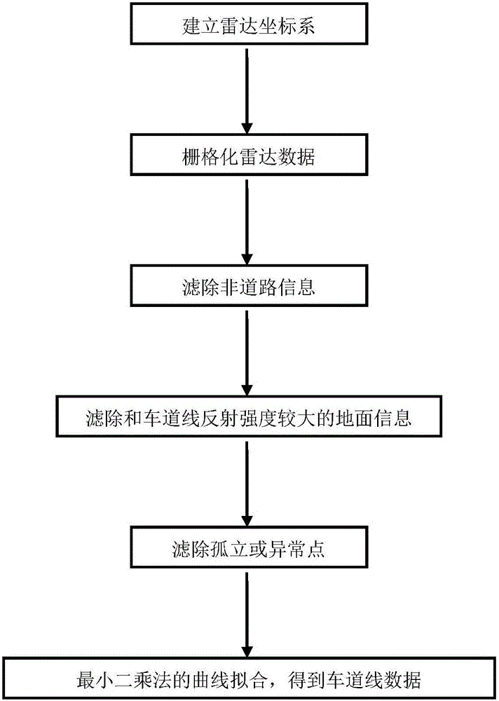
[0028] A road lane line detection method based on three-dimensional laser radar, the specific steps are:

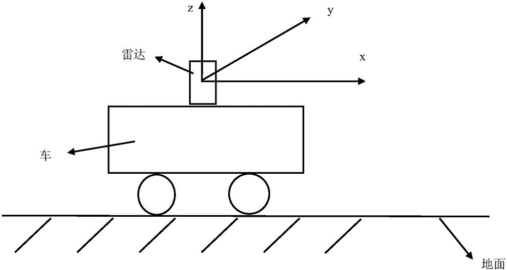
[0029] 1) Establish the radar coordinate system oxyz for detecting vehicles.

[0030] Such as figure 2 As shown, the radar coordinate system oxyz means that the detection vehicle is placed stationary on the ground, and the lidar is installed on the top of the detection vehicle, with the center of the lidar as the origin o, the x-axis passes through o and is horizontal to the ground, and the direction points to the detection vehicle The forward direction, the z-axis passes through o and is perpendicular to the ground, the direction points to the top of the vehicle, and the y-axis follows the right-hand rule, such as figure 2 direction toward the inside of the paper.

[0031] 2) Preprocessing the radar point cloud data.

[0032] Since the lidar can obtain po...


PUM


Abstract

The invention relates to a road lane line detection method based on a three-dimensional laser radar. The method comprises the following steps: 1) establishing the radar coordinate system oxyz of a detection vehicle; 2) establishing an area of interest under a radar coordinate system oxy, and carrying out rasterization processing on the data, which is collected by the laser radar, of the area of interest; 3) according to highest point data and lowest point data in a grid, filtering a non-ground grid, and utilizing the highest point data to filter a non-lane internal grid; 4) solving the average value of laser radar reflection intensity data in the grid, setting the threshold value of laser radar collection data reflection intensity, and filtering the grid which has a big difference with lane line reflection intensity; 5) filtering an isolate or exceptional grid which is close to lane line reflection intensity information; and 6) carrying out the curve fitting of a least square method on the above obtained grid to obtain a road lane line. The method can carry out real-time processing, can work day and night, and has the advantages of being high in detection effect accuracy, high in reliability and good in algorithm robustness.

Description

technical field [0001] The invention belongs to the field of traffic environment perception in smart car technology, and in particular relates to a real-time detection method of road lane lines based on three-dimensional laser radar, which is applied to autonomous driving or auxiliary driving of smart cars. Background technique [0002] Three-dimensional lidar is one of the important sensors for smart cars to obtain external environmental information. It has the advantages of high precision, real-time performance and reliability. Lidar is also widely used in the research of smart cars to perceive the environment. The point cloud data collected by each lidar sensor can be represented by Point(x, y, z, i), where x, y, z represent the actual distance of the detected environmental object, and i represents the reflection intensity of the lidar to the point , the size is 0-255, dimensionless. There are about 1.3 million returned data points per second in a cycle of 3D lidar point ...

Claims


Application Information

Patent Timeline
IPC IPC(8): G06K9/00
CPCG06V20/588
Inventor 李强杜煜宋晓帅
Owner BEIJING UNION UNIVERSITY
Why Eureka
Try Eureka