Airborne laser radar data vegetation extraction method

An airborne laser radar and extraction method technology, applied in the field of remote sensing science, can solve the problems of low classification accuracy, indistinguishability, and low network efficiency of massive laser point cloud data, and achieve the goal of improving detection rate and strong universality Effect

Active Publication Date: 2016-12-07
NANJING FORESTRY UNIV
View PDF9 Cites 21 Cited by
  • Summary
  • Abstract
  • Description
  • Claims
  • Application Information

AI Technical Summary

Problems solved by technology

[0005] Although many scholars have done a lot of research on urban vegetation extraction, there are still problems. For example, using LiDAR data and other data such as multispectral or hyperspectral to assist vegetation extraction and classification, although the classification accuracy can be improved to some extent, However, the more data sources are fused, the more complex the corresponding algorithm is, and it cannot distinguish small-scale or low vegetation; the network construction efficiency of massive laser point cloud data is low, the classifica

Method used


Image

  • Airborne laser radar data vegetation extraction method
  • Airborne laser radar data vegetation extraction method
  • Airborne laser radar data vegetation extraction method

Examples


Embodiment Construction

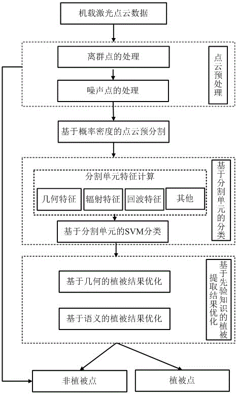
[0021] With reference to the accompanying drawings, a method for extracting vegetation from airborne lidar data comprises the following steps:

[0022] (1) Preprocessing of airborne lidar point cloud;

[0023] (2) Pre-segmentation of airborne lidar point cloud;

[0024] (3) Segmentation unit feature selection;

[0025] (4) Soft interval SVM classification based on kernel function;

[0026] (5) Optimization of rough classification results of data vegetation based on prior knowledge.

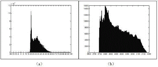
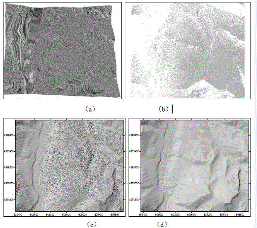
[0027] The preprocessing of the airborne laser radar point cloud, its specific method is: adopt the histogram statistical analysis method to determine the distribution law of the point cloud, by giving the ratio threshold value of gross difference point occupancy T , to filter out higher and lower rough points.

[0028] The pre-segmentation of the airborne laser radar point cloud, its specific method is:

[0029] Through the Gaussian distribution model with Perform probability density an...


PUM


Abstract

The invention brings forward an airborne laser radar data vegetation extraction method. The method comprises the following steps: 1, preprocessing of an airborne laser radar point cloud; 2, pre-segmentation of the airborne laser radar point cloud; 3, feature extraction of a segmentation unit; 4, soft interval SVM classification based on a kernel function; and 5, optimization of data vegetation classification results on the basis of prior knowledge. The method has the following advantages: 1, the method does not need fusion of other data sources such as multispectral images, high-spectral images and the like, thereby having quite high universality; 2, the method guarantees space self-correlation of the laser radar point cloud, effectively prevents a classification algorithm from damaging such a space attribute, ensures separability of vegetation and non-vegetation points and improves the vegetation detectability; and 3, the algorithm can effectively separate building circumference and stereo wall face points, building roof irregular object points and ground points of a vegetation-dense area from vegetation and realizes the purpose of accurately extracting the vegetation in an urban area.

Description

technical field [0001] The invention provides a method for extracting vegetation from airborne laser radar data, which belongs to the field of remote sensing science and technology. Background technique [0002] At present, the urban 3D model is playing an increasingly important role in urban landscape, tourism, real estate and other industries. The main features that make up the urban landscape are buildings and vegetation. When the requirements for urban 3D realism are not too high, urban modeling The main content is the modeling of urban buildings, and accurate vegetation extraction can create conditions for mainstream vegetation extraction algorithms: data-driven model-based building patch extraction algorithm RANSAC and fuzzy clustering algorithm to reduce irregular vegetation points The interference of cloud distribution on the extraction of building roof patches, with the increasingly prominent environmental problems, the reflection of urban and forest vegetation para...

Claims


Application Information

Patent Timeline
IPC IPC(8): G01S7/48
CPCG01S7/4802
Inventor 陈动杜建丽史晓云郑加柱史玉峰杨强王增利
Owner NANJING FORESTRY UNIV
Why Eureka
Try Eureka