Cascaded GNSS/SINS deep integrated navigation method

A deep integrated navigation and integrated navigation technology, which is applied in the field of cascaded GNSS/SINS deep integrated navigation, can solve problems involving high-dimensional Kalman filter and high-frequency calculations, and achieve the effect of improving performance

Inactive Publication Date: 2016-12-07
NANJING UNIV OF SCI & TECH
View PDF4 Cites 7 Cited by
  • Summary
  • Abstract
  • Description
  • Claims
  • Application Information

AI Technical Summary

Problems solved by technology

However, due to the highly nonlinear relationship between the observed quantity and the state quantity in the model, it

Method used


Image

  • Cascaded GNSS/SINS deep integrated navigation method
  • Cascaded GNSS/SINS deep integrated navigation method
  • Cascaded GNSS/SINS deep integrated navigation method

Examples


Embodiment Construction

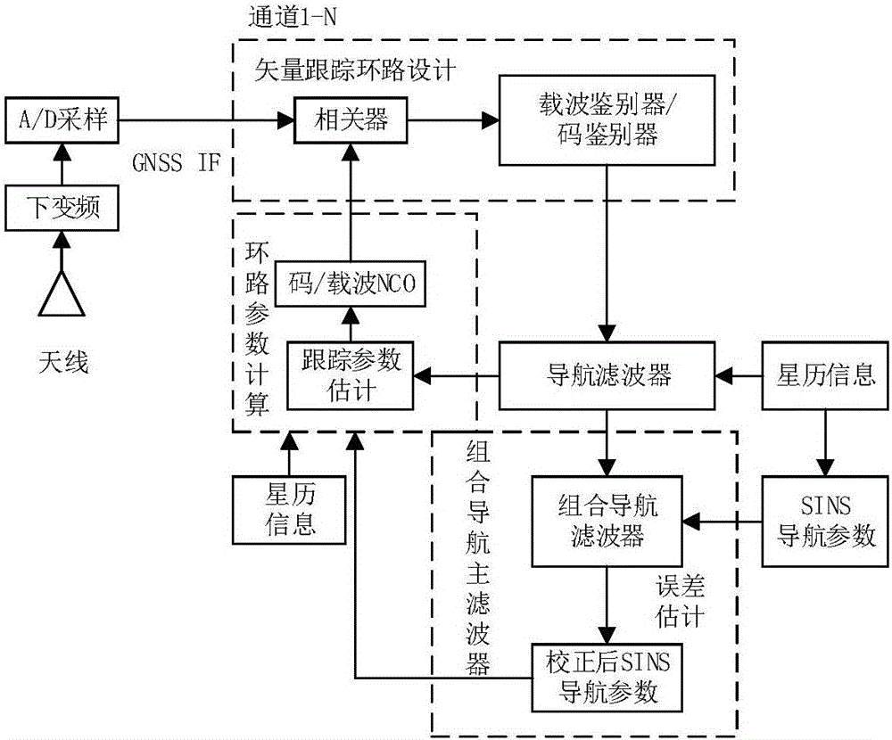
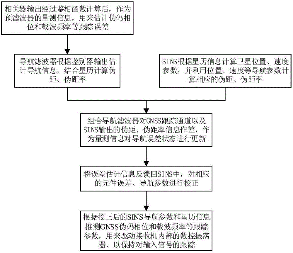
[0012] The present invention will be described in further detail below in conjunction with the accompanying drawings.

[0013] Such as figure 1 , 2 As shown, the cascaded GNSS / SINS deep integrated navigation method of the present invention is specifically realized as follows:

[0014] The radio frequency signal received by the GNSS antenna, taking the GPS satellite L1 frequency point as an example, the signal transmitted by the satellite is expressed as:

[0015] S L 1 ( t ) = 2 A · D ( t ) · C ( t ) · c o s [ ω L 1 t + φ ...


PUM


Abstract

The invention discloses a cascaded GNSS/SINS deep integrated navigation method. The method comprises a step of designing a vector tracking loop: a carrier discriminator and a code discriminator output measurement information for a guide filter and are used for estimating receiver position, speed, clock error and clock drift, and the estimated information is used for calculating a receiver loop parameter, a step of building an integrated guide main filter model: the integrated guide main filter receives the measurement information outputted by a GNSS tracking channel and an SINS, and updates a state variable and feeds a navigation error parameters back to an SINS system to correct an SINS system error, a step of calculating a loop parameter by using inertial information: an integrated system calculates a tracking loop parameter by using the corrected SINS navigation information and ephemeris information and is used for controlling the local pseudo code of the receiver and a carrier digital controlled oscillator so as to maintain the stable tracking of an input signal. The method has good anti-interference performance and instantaneous signal bridge connection ability, a good positioning effect can be obtained in a high dynamic environment and a weak signal environment, and prospect of application is wide.

Description

technical field [0001] The invention relates to the technical field of satellite navigation and integrated navigation, in particular to a cascading GNSS / SINS deep integrated navigation method. Background technique [0002] The GNSS system refers to the global navigation satellite system. The satellite navigation system has the advantages of all-weather and all-time, but it is susceptible to electromagnetic interference, and star loss and lock-up may occur under high dynamic conditions; A fully autonomous navigation system that does not radiate energy outside has the advantages of small size, high data update rate, and high short-term accuracy, but has the disadvantage that navigation accuracy decreases with time. Therefore, the two are often combined to form a SINS / GNSS integrated navigation system. With the continuous improvement of the carrier's demand for the comprehensive performance of the navigation system, the research on GNSS / SINS integrated navigation technology ha...

Claims


Application Information

Patent Timeline
IPC IPC(8): G01S19/49G01C21/16
CPCG01S19/49G01C21/165
Inventor 陈帅蒋长辉陈克振屈新芬韩乃龙沈际春卢启伟赵琛孔维一黄思亮
Owner NANJING UNIV OF SCI & TECH
Why Eureka
Try Eureka