Video image dynamic water level information extraction method based on geographical space-time scenes

A video image and information extraction technology, applied in image enhancement, image analysis, image data processing, etc., can solve the problems of poor timeliness of thematic information and failure to meet flood control requirements

Active Publication Date: 2016-12-14
HOHAI UNIV
View PDF2 Cites 13 Cited by
  • Summary
  • Abstract
  • Description
  • Claims
  • Application Information

AI Technical Summary

Problems solved by technology

Due to the limitation of the resolution of the existing remote sensing image and the accuracy of the digital elevation model, the refined water level information cannot be obtained through the existing remote sensing means. The timeliness of the existing thematic information extracted based on remote sensing images is poor, and it cannot meet the flood control requirements of the existing urban floods that need to quickly obtain accurate water level information

Method used


Image

  • Video image dynamic water level information extraction method based on geographical space-time scenes
  • Video image dynamic water level information extraction method based on geographical space-time scenes
  • Video image dynamic water level information extraction method based on geographical space-time scenes

Examples


Embodiment 1

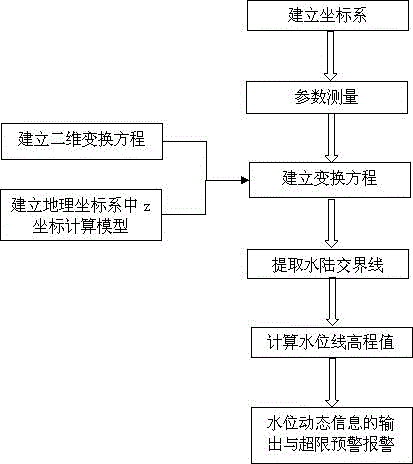
[0040] The present invention is a method for extracting dynamic water level information of a video image based on a geographical space-time scene, and the steps are as follows: figure 1 As shown, the specific steps are as follows:

[0041] (1) Establish a coordinate system:

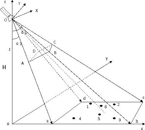
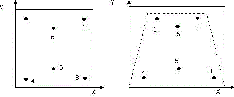
[0042] In key flood control areas, based on existing video surveillance equipment, such as river channel surveillance video, traffic surveillance video, etc., select typical surveillance points and use video surveillance equipment to monitor water level information and capture video images. Establish geographic coordinate system xyz and image coordinate system XY, such as figure 2 As shown, the rectangle abcd is the actual ground area covered by the surveillance video. Taking the projection point of the video equipment on the ground surface, i.e. point o, as the origin, the establishment of a three-dimensional spatial coordinate system constitutes the geographic coordinate system xyz, figure 2 The rec...

Embodiment 2

[0083] The difference between this embodiment and Embodiment 1 is that it also includes a transformation equation accuracy correction step, such as figure 2 As shown in , select two precision inspection feature points 5 and 6, and measure their geographic coordinates (x 5 ,y 5 ,z 5 ), (x 6 ,y 6 ,z 6 ) and the image coordinate values ​​are (X 5 ,Y 5 ), (X 6 ,Y 6 ), the image coordinate value (X 5 ,Y 5 ), (X 6 ,Y 6 ) into the established coordinate system conversion equation to obtain the converted geographic coordinate value (x ’ 5 ,y ’ 5 ,z ’ 5 ), (x ’ 6 ,y ’ 6 ,z ’ 6 ), and compare it with the measured geographic coordinate value (x 5 ,y5 ,z 5 ), (x 6 ,y 6 ,z 6 ) for comparison, calculate the transformation error by calculating its difference, and determine the accuracy correction parameter S x , S y , S z , to correct the transformation equation for accuracy.

[0084] (15)

[0085] (16).

[0086] Based on the theory of geographical...


PUM


Abstract

The present invention provides a video image dynamic water level information extraction method based on geographical space-time scenes. The method concretely comprises the following steps of (1) establishing a coordinate system; (2) measuring parameters; (3) establishing a conversion equation; (4) extracting the land-water intersection lines; (5) calculating a water level line elevation value; (6) outputting the water level dynamic information and carrying out the over-limit early warning alarm. According to the present invention, by carrying out the coordinate conversion of a two-dimensional image coordinate system and a three dimensional geographic coordinate system on the video images of the watercourses and the urban flood prevention flooding regions, a water level information extraction process based on the video images of the conventional watercourses and urban flood prevention flooding regions is realized, the insufficiency that the water level stations can not be set in the urban flood prevention flooding regions is made up to a certain extent, at the same time, the construction investment of the water level stations can be reduced to a certain extent. In addition, time interval scales are arranged on an imaging time shaft of a monitoring camera, and the dynamic water level change information of the appointed monitoring video stations is outputted, thereby monitoring the water level information of the video monitoring areas dynamically.

Description

technical field [0001] The invention relates to image recognition and geographical elevation information extraction technology, in particular to a method for extracting key dynamic water level information in images based on existing monitoring videos of river courses and urban flood-prone areas by using a geographical space-time scene framework. Background technique [0002] With the development of geographic information systems and the popularization and maturity of spatiotemporal scene theory, obtaining key information of objects based on geographic spatiotemporal scenes has become a new hotspot in the field of research. Due to the widespread occurrence of flood disasters in recent years, especially urban waterlogging, great losses have been caused to people's lives and property. The losses caused by flood disasters, especially urban waterlogging disasters, are often more caused by the lack of time-sensitive key information. Therefore, based on geographical space-time scen...

Claims


Application Information

Patent Timeline
Patent Type & Authority Applications(China)
IPC IPC(8): G06T7/20
CPCG06T7/20G06T2207/10016G06T2207/30181
Inventor 袁定波艾萍廖亨利岳兆新洪敏陈彬彬
Owner HOHAI UNIV
Why Eureka
Try Eureka