Fragmented remote sensing image synthesis method and device for cloudy and rainy region

A technology of remote sensing images and synthesis methods, applied in the field of remote sensing images, can solve the problems of lack of data information, poor radiation characteristics, and low multi-temporal data abundance in cloud layers and their shadow areas, so as to improve the application effect and scope of application, and improve the time and space. The effect of coverage

Active Publication Date: 2017-01-11
曾志康 +1
View PDF2 Cites 12 Cited by
  • Summary
  • Abstract
  • Description
  • Claims
  • Application Information

AI Technical Summary

Problems solved by technology

[0013] The purpose of the present invention is to provide a fragmented remote sensing image synthesis method and device for cloudy and rainy areas, so as to overcome the shortcomings of the existing multi-temporal data of low abundance and poor radiation characteristics
[0014] Another object of t...

Method used


Image

  • Fragmented remote sensing image synthesis method and device for cloudy and rainy region
  • Fragmented remote sensing image synthesis method and device for cloudy and rainy region
  • Fragmented remote sensing image synthesis method and device for cloudy and rainy region

Examples


Embodiment Construction

[0049] The specific embodiments of the present invention will be described in detail below in conjunction with the accompanying drawings, but it should be understood that the protection scope of the present invention is not limited by the specific embodiments.

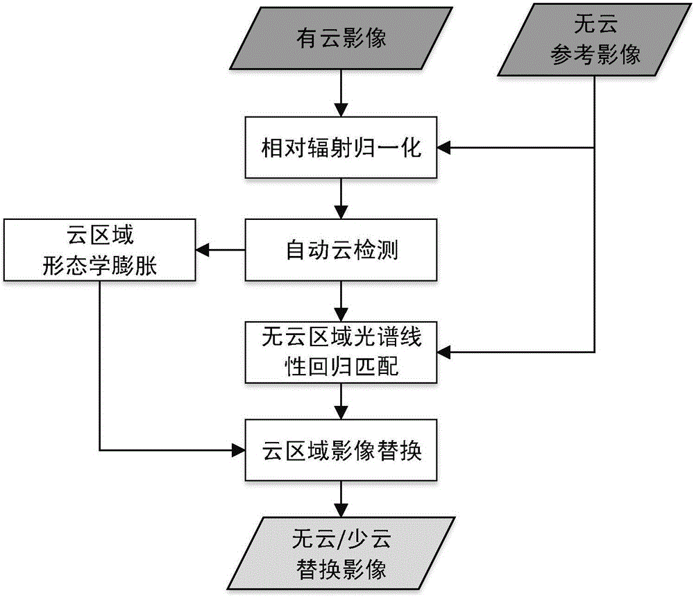
[0050] In conventional image processing procedures, images with cloud cover greater than 50% are generally discarded as useless image data, resulting in the loss of valid pixel information in cloud-free areas of images. Aiming at the difficulty in obtaining satellite images in cloudy and rainy areas in the south, it is difficult to meet the application problems of large-scale cloud-free image coverage. Image synthesis is carried out in this way, so as to meet the application requirements of cloud-free image data in cloudy and rainy areas.

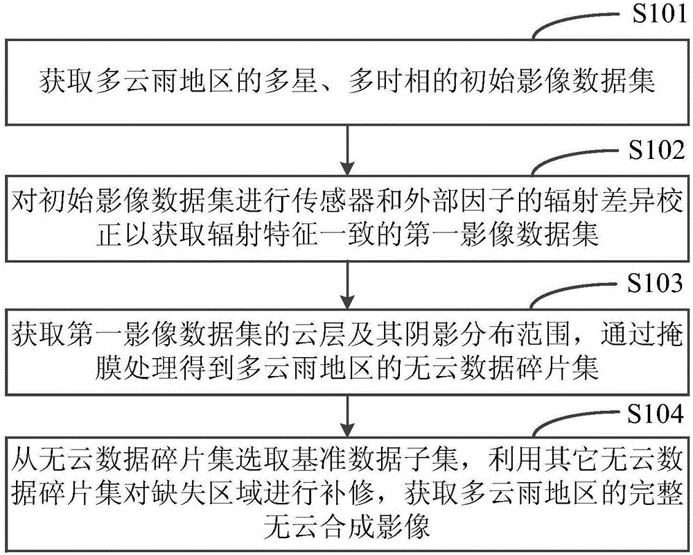
[0051] Such as figure 2 As shown, a method for synthesizing fragmented remote sensing images for cloudy and rainy regions according to a specific embodiment of the present inventi...


PUM


Abstract

The invention discloses a fragmented remote sensing image synthesis method and device for a cloudy and rainy region, and the method comprises the following steps: obtaining a multi-satellite and multi-phase initial image data set of the cloudy and rainy region; carrying out the radiation difference correction of a sensor and an external factor for the initial image data set, so as to obtain a first image data set consistent with the radiation features; obtaining a cloud layer and shadow distribution range of the first image data set, and obtaining a cloudless data fragment set of the cloudy and rainy region through mask processing; selecting a reference data subset from the cloudless data fragment set, repairing a loss region through employing other cloudless data fragment sets, and obtaining the complete cloudless synthetic image of the cloudy and rainy region. The method makes the most of conventional useless data (high cloud images) for synthesis, effectively improves the space-time coverage frequency of the remote sensing observation of the cloudy and rainy region, and provides powerful data support for the remote sensing application based the domestic satellite data especially the application with the high requirements for timeliness.

Description

technical field [0001] The invention relates to the field of remote sensing images, in particular to a fragmented remote sensing image synthesis method and device for cloudy and rainy areas. Background technique [0002] Due to the influence of marine monsoons or tropical and subtropical climate conditions, the eastern and southern provinces of my country have cloudy and rainy weather all year round, especially in the crop (vegetation) growing season, clear sky weather is rare, and it appears as large areas of clouds in remote sensing images. Due to cloud cover, surface information cannot be received by remote sensing sensors, making remote sensing applications that rely on optical satellite remote sensing, such as resource investigation, ecological environment protection, and crop remote sensing monitoring, unable to obtain cloud-free image data in key phases. With the continuous advancement of my country's satellite technology, a variety of satellites with different spatial...

Claims


Application Information

Patent Timeline
IPC IPC(8): G06T5/40G06T5/50
CPCG06T5/40G06T5/50
Inventor 曾志康覃泽林李宇翔黄启厅莫小香陆宇明兰宗宝孔令孜
Owner 曾志康
Why Eureka
Try Eureka