Vehicle integrated positioning system and method based on map matching

A positioning system and map matching technology, applied in the field of vehicle combination positioning system based on map matching, can solve problems such as vehicle positioning that is not suitable for a large range, and achieve the effect of narrowing the map range

Inactive Publication Date: 2017-02-01
SHANGHAI JIAO TONG UNIV
View PDF9 Cites 10 Cited by
  • Summary
  • Abstract
  • Description
  • Claims
  • Application Information

AI Technical Summary

Problems solved by technology

It is suitable for outdoor large-scale area positioning. However, because the road network positioning is based on maps, as the positioning range expands, the real-time performance of the method faces challenges, and it is not suitable for direct application to large-scale vehicle positioning.

Method used


Image

  • Vehicle integrated positioning system and method based on map matching
  • Vehicle integrated positioning system and method based on map matching
  • Vehicle integrated positioning system and method based on map matching

Examples


Embodiment Construction

[0030] The present invention will be described in detail below in conjunction with specific embodiments. The following examples will help those skilled in the art to further understand the present invention, but do not limit the present invention in any form. It should be noted that those skilled in the art can make several modifications and improvements without departing from the concept of the present invention. These all belong to the protection scope of the present invention.

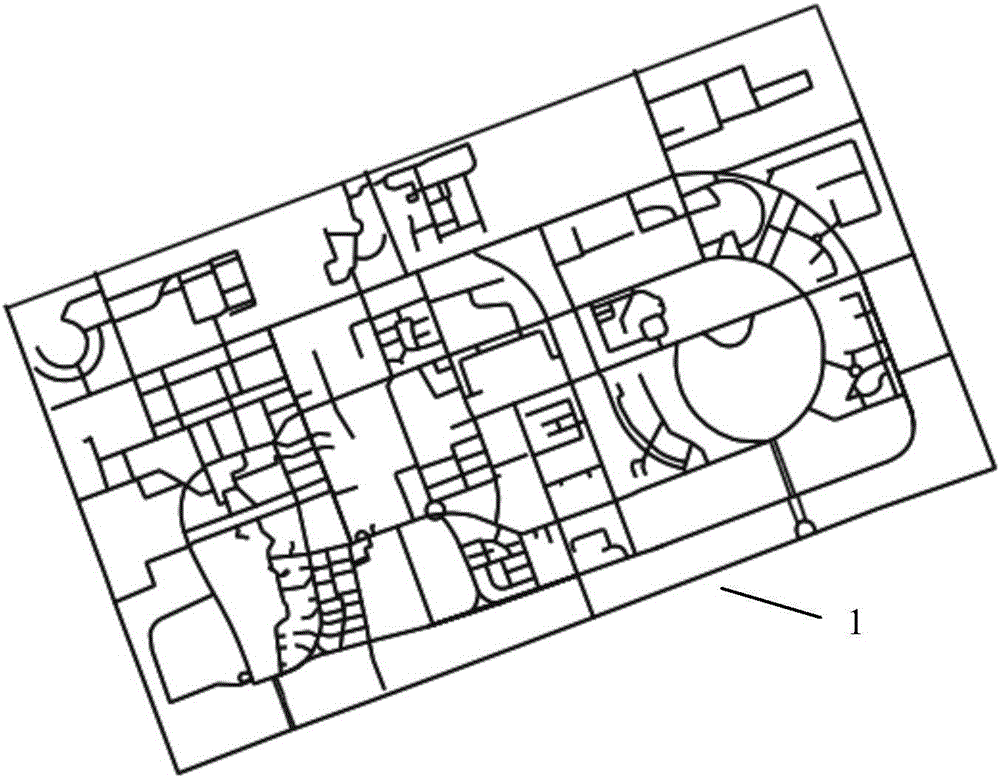
[0031] Such as figure 1 Shown is the road network of the current environment of a preferred embodiment figure 1 , for map matching; figure 1 The middle black line represents the road in the environment, take out the black line and sample the black line, record the position of the point in the road at a certain interval, and the connection relationship between the road and the road, that is, get the road network map in the form of database; use the road The network map is matched with the displac...


PUM


Abstract

The invention provides a vehicle integrated positioning system and method based on map matching. The system comprises a mobile phone communication module, an inertial navigation unit, a vehicle-mounted speedometer and a controller, wherein the mobile phone communication module is used for obtaining coarse position information of a vehicle, determining the range of a candidate map according to the position and extracting a corresponding road net map; the inertial navigation unit is used for acquiring a change in the course angle of the vehicle; the vehicle-mounted speedometer is used for obtaining a traveling distance of the vehicle; and the controller is used for matching a sensor input with the road net map, thereby outputting the position and orientation of the vehicle. The method is based on probability matching of the road net map, and the map is stored off line in a computing device or acquired on line; the result of the method is hardly influenced by the environment, and the environment does not need to be reconstructed; and the method can be used for replacing a GPS (global positioning system) to realize wide-range real-time vehicle positioning.

Description

technical field [0001] The present invention relates to the technical field of vehicle positioning, in particular to a combined vehicle positioning system and method based on map matching. Background technique [0002] Due to the continuous improvement of the level of urbanization, people's production and life are increasingly inseparable from vehicle navigation and positioning. Vehicle positioning is a component and supporting technology of the vehicle navigation system, and GPS positioning is the most widely used at present. The civilian GPS technology is mature and the cost is low, but in the complex and dense urban environment, GPS signals often fail due to occlusion, and a stable and real-time vehicle positioning system is still required at this time. [0003] At present, the technologies used to replace the GPS positioning system include magnetic nail positioning and laser radar positioning. Although magnetic nail positioning can ensure accuracy, it is necessary to m...

Claims


Application Information

Patent Timeline
Patent Type & Authority Applications(China)
IPC IPC(8): G01C21/30H04W4/02H04W4/04
CPCG01C21/30H04W4/02H04W4/023
Inventor 杨明李天一王春香王冰
Owner SHANGHAI JIAO TONG UNIV
Why Eureka
Try Eureka