Assisted enhancement navigation method and device

A technology of auxiliary enhancement and navigation method, which is applied in the computer field, can solve problems such as occlusion, navigation signal interference, unavailability, etc., and achieve the effects of high signal strength, improved sensitivity, and fast change of elevation angle

Active Publication Date: 2017-02-22
TSINGHUA UNIV
View PDF4 Cites 35 Cited by
  • Summary
  • Abstract
  • Description
  • Claims
  • Application Information

AI Technical Summary

Problems solved by technology

However, with the advancement of its navigation and positioning technology and the expansion of its application fields, some special occasions put forward higher standard requirements for its positioning accuracy, anti-interference ability, response speed, sensitivity, etc., such as cities, indoors, forests, etc. In various complex environments such as mining areas, traditional GPS / BDS navigation signals will be severely interfered and blocked, and may even lead to unavailability

Method used


Image

  • Assisted enhancement navigation method and device
  • Assisted enhancement navigation method and device
  • Assisted enhancement navigation method and device

Examples


Embodiment Construction

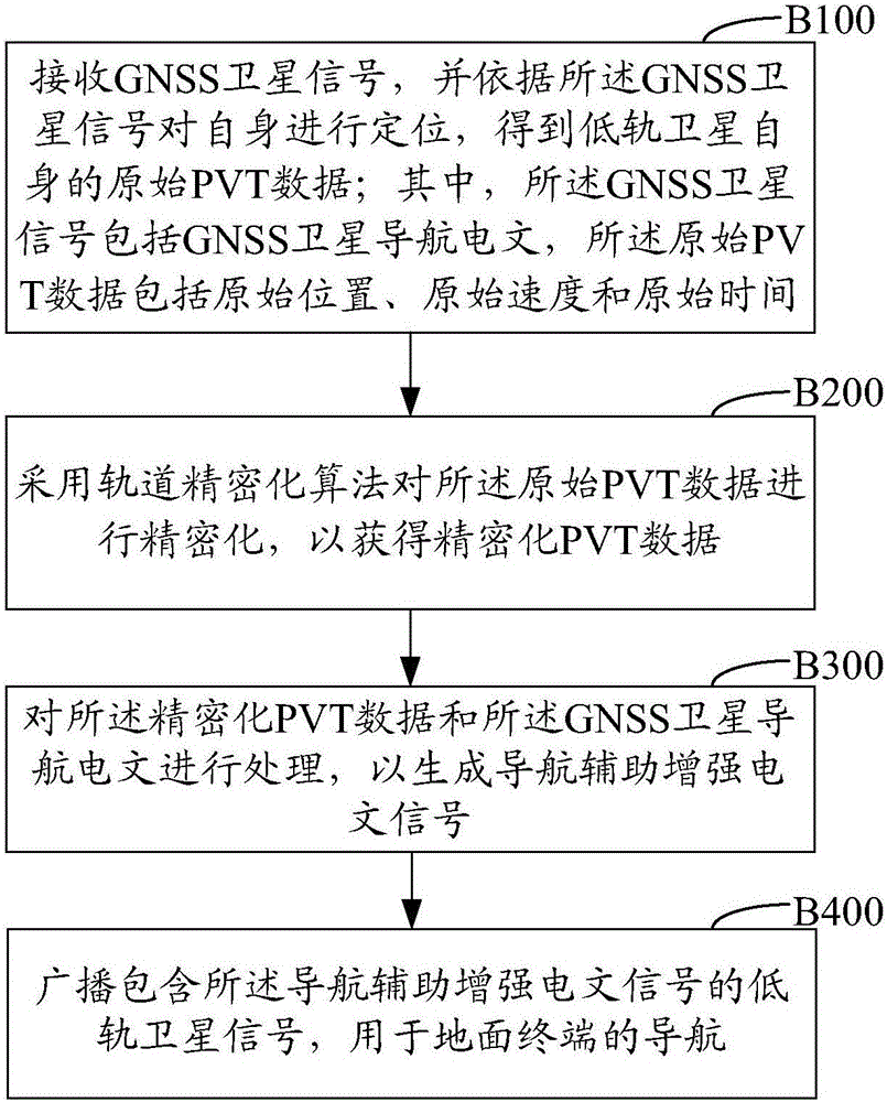
[0055] The present invention will be further elaborated below in conjunction with the accompanying drawings and embodiments, with reference to the accompanying drawings. It should be understood that these examples are only used to illustrate the present invention and are not intended to limit the scope of the present invention. In addition, it should be understood that after reading the content taught by the present invention, those skilled in the art can make various changes or modifications to the present invention, and these equivalent forms also fall within the scope defined by the appended claims of the present application.

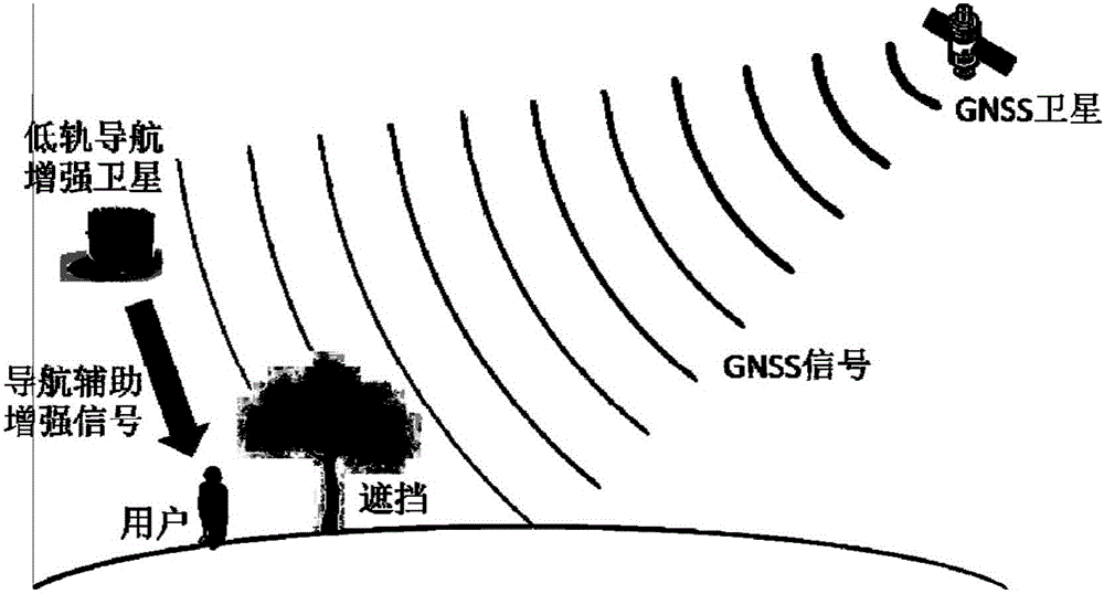
[0056] figure 1 It is a block diagram of the basic composition of the low-orbit satellite navigation auxiliary enhancement system of the present invention. like figure 1 As shown, the low-orbit satellite navigation aid enhancement system according to the present invention includes GNSS satellites, low-orbit satellites and user terminals. The low-o...


PUM


Abstract

Provided is an assisted enhancement navigation method and device. The method includes receiving a GNSS satellite signal and locating itself according to the GNSS satellite signal to obtain the original PVT data of the low-orbit satellite itself, wherein the GNSS satellite signal includes a GNSS satellite navigation message, and the original PVT data includes the original location, the original speed and the original time; making precision of the original PVT data by means of a track precision algorithm to obtain the precision PVT data; processing the precision PVT data and the GNSS satellite navigation message to generate a navigation assisted enhancement message signal; and broadcasting a low-orbit satellite signal containing the navigation assisted enhancement message signal for the navigation of a ground terminal. The assisted enhancement navigation method and device provided by the invention improve the precision of navigation.

Description

technical field [0001] The invention relates to the field of computer technology, in particular to an auxiliary enhanced navigation method and equipment. Background technique [0002] Global Navigation Satellite System (GNSS), including in particular the US Global Positioning System (GPS), the Russian Global Navigation Satellite System (GLONASS), the European Galileo system (Galileo) and the Chinese Beidou The four core navigation systems (Compass, BDS) are the basis of various radio positioning technologies. GNSS can provide users with all-weather navigation and positioning services around the world, and its application prospects are very broad. However, with the advancement of its navigation and positioning technology and the expansion of its application fields, some special occasions put forward higher standard requirements for its positioning accuracy, anti-interference ability, response speed, sensitivity, etc., such as cities, indoors, forests, etc. In various comple...

Claims


Application Information

Patent Timeline
Patent Type & Authority Applications(China)
IPC IPC(8): G01S19/46G01S19/25
CPCG01S19/252G01S19/254G01S19/258G01S19/46
Inventor 陈曦王梦璐黄振匡麟玲
Owner TSINGHUA UNIV
Why Eureka
Try Eureka