

Cloud control navigator system for reporting road conditions in real time
A real-time road condition and navigator technology, applied in the field of car navigation, can solve the problems that the navigator cannot remind, the car owner reports real-time traffic congestion information, and wastes a lot of time waiting for the road to pass, so as to improve safety and stability, optimize anti-theft performance, The effect of avoiding false positives
- Summary
- Abstract
- Description
- Claims
- Application Information
AI Technical Summary
Problems solved by technology
Method used
Image

Examples
Embodiment 1
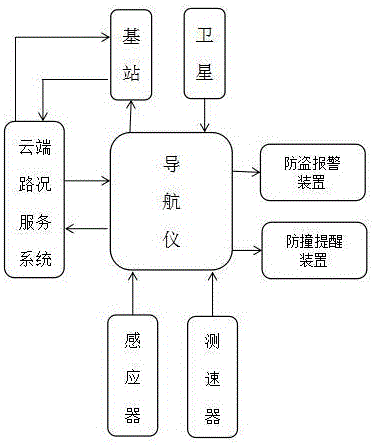
[0029] Reference attached figure 1 , 2 , a cloud-controlled navigator system that reports road conditions in real time, including a navigator, a base station, and a navigation satellite. The navigator is built with a positioning module, and the positioning information is transmitted to the base station through satellite positioning. The base station is equipped with a cloud vehicle condition server system.
[0030] The cloud server system is used to receive the location information of the car body, analyze the data and plan the optimal driving route and road congestion, and then transmit the information to the navigator, which combines the received road congestion situation with the electronic map to form a real-time road condition map , car owners can save time by avoiding congested roads according to the optimal driving route.
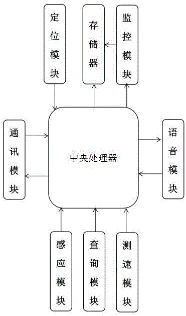
[0031] The navigator is also equipped with a query module, a speed measurement module, a sensing module, a reminder module and a communication modu...
PUM
 Abstract
Description
Claims
Application Information