Compression method of geographic information image

A technology of geographic information and compression method, applied in the field of geographic information image compression, can solve problems such as affecting the use effect of geographic information images, and achieve the effect of reducing the amount of calculation and high computing speed.

Pending Publication Date: 2017-04-05
TIANJIN JUNBANG TECH CO LTD
View PDF0 Cites 2 Cited by
  • Summary
  • Abstract
  • Description
  • Claims
  • Application Information

AI Technical Summary

Problems solved by technology

Although computer hardware technology has developed rapidly, when these geographic information images are expected to be widely used on the network, the performance limitations of network bandwidth and terminal equipment will still affect the use of these geographic information images

Method used


Image

  • Compression method of geographic information image
  • Compression method of geographic information image

Examples


Embodiment Construction

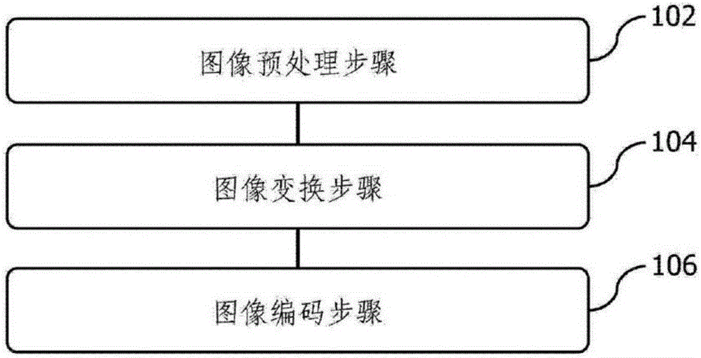
[0016] refer to figure 1 As shown, the present invention proposes a kind of compression method of geographical information image, comprises the following steps:

[0017] 102. The image preprocessing step is to obtain the geographic information image, and divide the geographic information image into blocks according to the terrain law in the geographic information image. In one embodiment, the terrain law includes the ruggedness of the terrain, which can be defined in the following manner: in a selected area, the area whose altitude is within the range of ±1096 of the average altitude of the area percentage of the total area of ​​the region. When the ratio is above 7096, the roughness of the area is flat. When the ratio is between 30% and 70%. Yes, the area is moderately rough. When the ratio is below 3096, the area is highly rugged. In one embodiment, another factor that needs to be considered in the terrain law is the division of administrative regions. Usually, roughne...


PUM


Abstract

The invention discloses a compression method of a geographic information image. The method includes: an image preprocessing step, obtaining the geographic information image, and partitioning the geographic information image according to a terrain rule of the geographic information image, wherein the terrain rule comprises the terrain roughness degree; an image transformation step, for each block, performing transformation processing on the image by employing two-dimensional wavelet transformation, wherein two-dimensional wavelet transformation employs biorthogonal wavelet, the two-dimensional wavelet transformation is decomposed into twice of one-dimensional wavelet transformation for processing, the twice of one-dimensional wavelet transformation includes low-frequency data transformation and high-frequency data transformation which are processed in parallel; and an image coding step, quantifying the image through two-dimensional wavelet transformation, and then performing coding, wherein the coding is performed by employing the 801 algorithm. According to the method, the calculation amount of image processing is small, the operation speed is higher, and the image quality is not substantially affected.

Description

technical field [0001] The invention relates to geographic information processing technology, in particular to a method for compressing geographic information images. Background technique [0002] The application of geographic information system (GIS) is developing rapidly. The basis of GIS is high-definition, high-resolution and highly accurate electronic maps. Electronic maps can display three-dimensional terrain and are of great value in military simulation, urban planning, digital technology applications and other fields. [0003] High-definition and high-resolution electronic maps mean geographic information images with a huge amount of data. When using these images, the computer needs to have a large memory capacity and storage space, as well as a strong computing power. Although computer hardware technology has developed rapidly, when these geographic information images are expected to be widely used on the network, the performance limitations of network bandwidth ...

Claims


Application Information

Patent Timeline
Patent Type & Authority Applications(China)
IPC IPC(8): G06T9/00H03M7/40
CPCG06T9/007H03M7/40
Inventor 包训阳
Owner TIANJIN JUNBANG TECH CO LTD
Why Eureka
Try Eureka