
Method for automatic management of airborne navigation transceiver

A radio transceiver and automatic management technology, applied in the field of regional navigation, can solve problems such as unsatisfactory real-time performance, and achieve the effect of reducing workload and facilitating engineering realization

Active Publication Date: 2017-05-10
CHINESE AERONAUTICAL RADIO ELECTRONICS RES INST
View PDF3 Cites 4 Cited by
  • Summary
  • Abstract
  • Description
  • Claims
  • Application Information

AI Technical Summary

Problems solved by technology

[0007] The purpose of this invention is to solve the problem that the existing area navigation system manually manages the onboard navigation radio transceivers that cannot meet the real-time requirements, and proposes a method for automatically managing the onboard radio transceivers. Adaptive channels with different numbers Radio transceivers, so that each radio transceiver is in proper working condition, reduce the workload of pilots, and provide technical support for civil aircraft to achieve regional navigation

Method used


Image

  • Method for automatic management of airborne navigation transceiver

Examples


Embodiment Construction

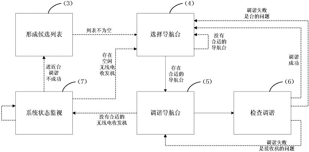
[0020] The technical scheme of the present invention is described in detail below in conjunction with accompanying drawing:

[0021] The invention aims at the needs of the regional navigation system for radio navigation station tuning, fully utilizes the current position of the aircraft and the information of the current flight segment, takes into account the working state of the radio transceiver when selecting the navigation station, and considers the attributes of the navigation station when tuning the radio transceiver. Enables automatic management of onboard radio transceivers. Specifically include the following steps:

[0022] (1) Read the aircraft position information output by the area navigation device at a period ΔT, and the position information is longitude L, latitude λ, and altitude h.

[0023] (2) Read the navigation station information stored by the area navigation equipment with a cycle ΔT, including: the frequency f of the navigation station NAV (i), longitu...


PUM


Abstract

The invention discloses a method for automatic management of an airborne navigation transceiver. The method includes: forming a candidate navigation station list according to airplane current position information, and if the list is not null, selecting to-be-tuned navigation stations in the next period; if no appropriate navigation station is found, keeping searching in the next period; if the appropriate navigation station is found, tuning the found navigation station; if no transceiver is available, performing system status monitoring in the next period; if the available transceiver is found, tuning the navigation station, and checking tuning of the navigation station; if tuning succeeds, selecting other navigation stations in the next period. The method is easy for engineering implementation and has important practical application significance to meeting of area navigation required functions of aircrafts flying in civil fields.

Description

technical field [0001] The invention belongs to the technical field of area navigation. Background technique [0002] Area navigation is a navigation method that enables aircraft to fly along any desired path within the coverage area of ​​the navigation system signal, or within the working capability of the onboard navigation equipment, or a combination of both. Regional navigation uses signals from multiple navigation sources to continuously calculate the geographic location of the aircraft through regional navigation equipment, thereby obtaining real-time navigation information. [0003] The signal sources currently available for area navigation mainly include: Volt / range finder (VOR / DME), range finder / range finder (DME / DME), global navigation satellite system (GNSS), inertial reference system (IRS) . Considering my country's existing navigation facilities layout and satellite navigation application policies and other factors, regional navigation based on VOR / DME and DME...

Claims


Application Information

Patent Timeline
Patent Type & Authority Applications(China)
IPC IPC(8): G01C21/00G01S1/04G01S5/02H04B1/74
CPCG01C21/005G01S1/04G01S5/0205H04B1/74
Inventor 王丹马航帅孙晓敏
Owner CHINESE AERONAUTICAL RADIO ELECTRONICS RES INST
Learn More