Method for automatically extracting height of building based on stereoscopic satellite image

A technology of building height and automatic extraction, applied in the field of satellite image interpretation

Active Publication Date: 2017-06-20
MAPUNI TECH CO LTD
View PDF14 Cites 11 Cited by
  • Summary
  • Abstract
  • Description
  • Claims
  • Application Information

AI Technical Summary

Problems solved by technology

[0004] The purpose of the present invention is to provide a method for automatically extracting buildin

Method used


Image

  • Method for automatically extracting height of building based on stereoscopic satellite image

Examples


Embodiment

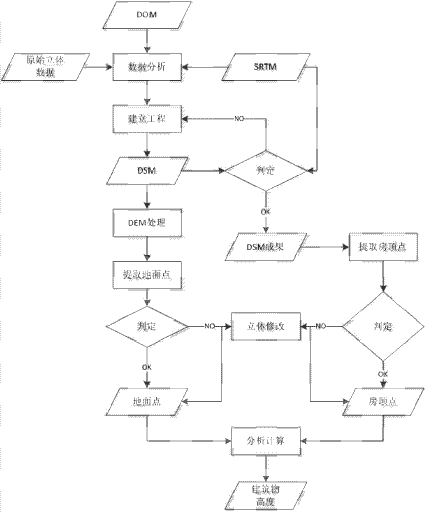
[0023] The method for automatically extracting building heights based on stereo satellite images described in this embodiment, the method includes:

[0024] S1, obtaining the original satellite stereo image pair, SRTM data and DOM data of the target building; using the SRTM data and the DOM data as the directional point data source of absolute orientation; wherein, the SRTM data is used as the directional point elevation control The data source, the DOM data are used as the data source of the directional point plane control;

[0025] S2, preprocessing the original satellite stereo image pair of the target building, performing relative orientation and absolute orientation on the preprocessed image pair in turn, and judging whether the plane error and the elevation error of the stereo image pair after the absolute orientation reach a preset threshold, If yes, generate epipolar images for extracting DSM data, and enter S3; if no, repeat S2;

[0026] S3. Perform matching processi...


PUM


Abstract

The invention discloses a method for automatically extracting height of a building based on a stereoscopic satellite image, and relates to the field of satellite image interpretation. The method comprises the following steps of obtaining an original stereoscopic satellite image pair, SRTM data and DOM data of a target building; pre-processing the original stereoscopic satellite image pair, and performing relative orientation and absolute orientation in sequence to generate an epipolar image used for extracting DSM data; extracting initial DSM data of the target building, referring to a DLG data road image layer, a landform image layer and the DOM data of the target building to obtain a check point which meets the requirements; obtaining DEM data in which elevation information of the target building is removed by filtering; integrating the data; performing stereoscopic checking and correcting on a top point elevation value and a foundation elevation value of the target building; subtracting the foundation elevation value of the building from the top point elevation value of the building to obtain the elevation information of the building by combining a house image layer of the target building in DOM and DLG. The method can be used for extracting the elevation information of the building more quickly and more efficiently.

Description

technical field [0001] The invention relates to the field of satellite image interpretation, in particular to a method for automatically extracting building heights based on stereo satellite images. Background technique [0002] Since the 20th century, remote sensing technology has become more and more mature, and low-altitude aircraft has developed rapidly. The image extraction technology based on this is becoming more and more mature. At the same time, with the application of 3D technology, the extraction of building elevation information plays an important role. Existing techniques for extracting building elevation information include laser rangefinders, stereo image pairs, optical image height measurements, and shadow ranging methods. However, these methods all have shortcomings: [0003] Due to the large influence of human factors on the laser range finder, the errors are unbalanced, and the workload of checking the collected data is heavy. Stereo image pairing requir...

Claims


Application Information

Patent Timeline
IPC IPC(8): G01C5/00G01C11/02
CPCG01C5/00G01C11/02
Inventor 李月华陈雷胡磊宋双科姚勇
Owner MAPUNI TECH CO LTD
Why Eureka
Try Eureka