Distributed type INS/UWB tightly-coupled navigation system and method

A tightly combined and distributed technology, applied in navigation, navigation through velocity/acceleration measurement, mapping and navigation, etc., can solve problems such as poor system fault tolerance, disadvantageous integrated navigation technology accuracy, and reduced application scope of integrated navigation models. To achieve the effect of improving accuracy and robustness

Inactive Publication Date: 2017-06-20
UNIV OF JINAN
View PDF5 Cites 16 Cited by
  • Summary
  • Abstract
  • Description
  • Claims
  • Application Information

AI Technical Summary

Problems solved by technology

For example, UWB devices are required to provide pedestrian navigation information, which requires that the environment where the target pedestrian is located must be able to obtain at least three reference node information, which greatly reduces the application range of the integrated navigation model. The sub-technology completes the positioning independently, but also introduces new errors, which is not conducive to the improvement of the accuracy of integrated navigation technology
In order to overcome this problem, scholars proposed to apply the tight combination model to the field of indoor pedestrian navigation. The tight combination model directly applies the original sensor data of the sub-techniques involved in the combined navigation to the final navigation information calculation, reducing the sub-techniques’ self-discipline. Solve the risk of introducing new errors and improve the accuracy of integrated navigation. However, it should be pointed out that the existing compact integrated navigation models all use a centralized model. This method has poor system fault tolerance and is not conducive to increasingly accurate and complex integrated navigation. Model
[0005] In the patent document "An IMU / WSN Integrated Navigation Method for Indoor Mobile Robots", the method uses a local filter in the WSN pseudo-range estimation part, which effectively improves the pseudo-range estimation accuracy, but in the subsequent The data fusion part still adopts a centralized mode, and the centralized mode makes this centralized integrated navigation mode still unable to improve its fault tolerance. Therefore, it is necessary to conduct research on how to improve the fault tolerance of the navigation system.

Method used


Image

  • Distributed type INS/UWB tightly-coupled navigation system and method
  • Distributed type INS/UWB tightly-coupled navigation system and method
  • Distributed type INS/UWB tightly-coupled navigation system and method

Examples


Embodiment 1

[0056] Embodiment 1: as figure 1 As shown, a distributed INS / UWB tight integrated navigation system includes an inertial navigation device, a pseudo-range detection unit, a wireless data transmission system and a data processing system;

[0057] The inertial navigation device is used to measure the navigation information of pedestrians, and the navigation information includes position, speed and attitude information; the pseudo-range detection unit is used to obtain the pseudo-range information: the wireless data transmission system is connected with the inertial navigation device and the pseudo-range detection unit, It is used to transfer the data collected by the inertial navigation device and the pseudo-range detection unit to the data processing system through wireless transmission, and transfer the control command sent by the data processing system to the inertial navigation device; the data processing system: adopts distributed The data fusion estimation unit is used for...

Embodiment 2

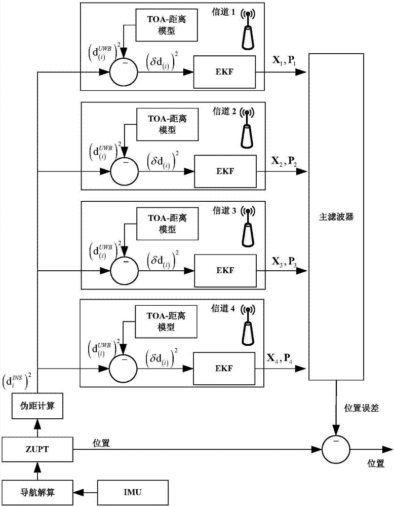
[0063] Embodiment 2: as figure 2 As shown, a distributed INS / UWB tight integrated navigation method adopts the following steps:

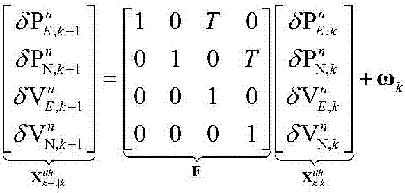
[0064] (1) Using the error vector of the inertial navigation device and the position information of each UWB reference node as the state quantity, and the position information and pseudo-range information of the target pedestrian collected by the inertial navigation device as the system observations, construct the INS / UWB tight integrated navigation model ;

[0065] (2) According to the INS / UWB tight integrated navigation model, perform data fusion estimation on the navigation information and pseudorange information of the target pedestrian in each wireless communication channel, and obtain the navigation information of the current wireless communication channel and the target pedestrian at the current moment best estimate;

[0066] (3) Perform data fusion estimation on the optimal estimates obtained in each wireless communication channel to obta...

Embodiment 3

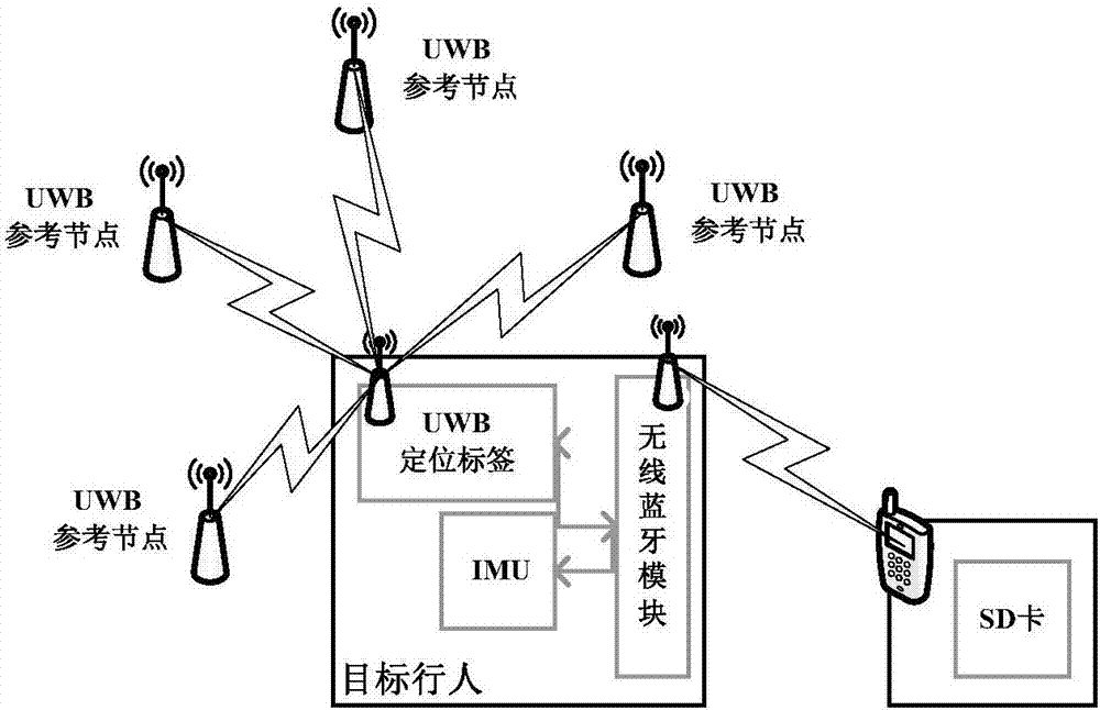
[0069] Embodiment 3: A distributed INS / UWB tight integrated navigation, including: an inertial navigation device IMU, a UWB positioning tag, a UWB reference node and a data processing system;

[0070] The inertial navigation device INS and the UWB positioning tag are respectively set on the pedestrian's hat, the UWB reference node is set at any position, and the inertial navigation device INS and the UWB positioning tag are respectively connected to the data processing system.

[0071] Among them, the inertial navigation device INS: used to measure the navigation information such as the position, speed and attitude of pedestrians;

[0072] UWB positioning tag: used to measure the distance information between the UWB positioning tag and the reference node, that is, pseudo-range information;

[0073] UWB reference node: placed in a known position in advance, easy to measure and locate the distance between tags;

[0074] Data processing system: used for data fusion of collected ...


PUM


Abstract

The invention discloses a distributed type INS / UWB tightly-coupled navigation system and method. The system comprises an inertial navigation device, a pseudorange detection unit, a wireless data transmission system and a data processing system; the inertial navigation device is used for measuring the navigation information of pedestrian, wherein the navigation information includes position, speed and posture information; the pseudorange detection unit is used for acquiring pseudorange information; the wireless data transmission system is connected with the inertial navigation device and the pseudorange detection unit, and used for transmitting the data, acquired by the inertial navigation device and the pseudorange detection unit, into the data processing system through wireless transmission, and transmitting a control command, sent by the data processing system, to the inertial navigation device; and the data processing system is used for performing data integration estimation on collected data by adopting a distributive type data integration estimation unit, and sending the control command to the inertial navigation device. According to the distributed type INS / UWB tightly-coupled navigation system and the method, influence of the interior complicated navigation environment on the integrated navigation precision can be reduced so as to obtain the optimal pre-estimation on the navigation information of target pedestrian.

Description

technical field [0001] The invention relates to the technical field of combined positioning in complex environments, in particular to a distributed INS / UWB tight combined navigation system and method. Background technique [0002] In recent years, Pedestrian Navigation (PN), as an emerging field of navigation technology application, is receiving more and more attention from scholars from all over the world, and has gradually become a research hotspot in this field. However, in indoor environments such as tunnels, large warehouses, and underground parking lots, factors such as weak external radio signals and strong electromagnetic interference will have a great impact on the accuracy, real-time performance, and robustness of target pedestrian navigation information acquisition. How to effectively integrate the limited information acquired in the indoor environment to eliminate the influence of the indoor complex environment and ensure the continuous stability of pedestrian na...

Claims


Application Information

Patent Timeline
Patent Type & Authority Applications(China)
IPC IPC(8): G01C21/16
CPCG01C21/165
Inventor 徐元程金赵钦君王滨部丽丽
Owner UNIV OF JINAN
Why Eureka
Try Eureka