Hand-held ground station for unmanned aerial vehicle and surveying and mapping and positioning method thereof

A positioning method and ground station technology, applied in the agricultural field, can solve problems such as increasing the workload of plant protection, reduce equipment and transportation investment, enhance positioning accuracy, and reduce manpower input.

Pending Publication Date: 2017-07-07
JIAGUTECH CO LTD
View PDF10 Cites 9 Cited by
  • Summary
  • Abstract
  • Description
  • Claims
  • Application Information

AI Technical Summary

Problems solved by technology

[0006] 3. If there is no network signal in the field, it is necessary to make a trip during surveying and mapping, which increases the workload of plant protection.

Method used


Image

  • Hand-held ground station for unmanned aerial vehicle and surveying and mapping and positioning method thereof
  • Hand-held ground station for unmanned aerial vehicle and surveying and mapping and positioning method thereof
  • Hand-held ground station for unmanned aerial vehicle and surveying and mapping and positioning method thereof

Examples


Embodiment Construction

[0062] In order to enable those skilled in the art to better understand the technical solutions in the embodiments of the present invention, and to make the above-mentioned purposes, features and advantages of the embodiments of the present invention more obvious and understandable, the following describes the technical solutions of the present invention through the accompanying drawings and embodiments The technical solution is further described in detail. Based on the embodiments of the present invention, all other embodiments obtained by persons of ordinary skill in the art without creative efforts fall within the protection scope of the present invention.

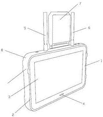
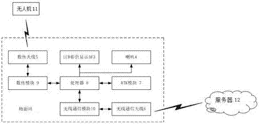
[0063] figure 1 It is a structural diagram of a handheld ground station for drones according to an embodiment of the present invention.

[0064] like figure 1 As shown, the embodiment of the present invention provides a kind of handheld intelligent ground station of unmanned aerial vehicle, and it comprises housing, a...


PUM


Abstract

The invention provides a hand-held ground station for an unmanned aerial vehicle and a surveying and mapping and positioning method thereof. The method comprises the following steps: receiving a surveying and mapping point positioning request instruction, and recording and keeping the surveying and mapping point positioning request instruction; according to the surveying and mapping point positioning request instruction, calculating a ground station coordinate through an RTK base station and a satellite, wherein the ground station coordinate is a surveying and mapping point position coordinate; carrying out one-to-one correspondence integration on the calculated position coordinates and surveying and mapping point positioning requests and keeping the integration results locally; and sending the integration results to the unmanned aerial vehicle and a background server. According to the unmanned aerial vehicle ground station, through RTK positioning, positioning accuracy of the surveying and mapping point, a landing point when the unmanned aerial vehicle returns and safety distance during flight is improved; and besides, through surveying and mapping of the ground station, the ground station can carry out pre-spray surveying and mapping instead of a conventional hand-held surveying and mapping rod, and plant protection work can be finished without uploading the surveying and mapping result to the background server, thereby reducing requirement for an environment network.

Description

technical field [0001] The invention relates to the field of agricultural technology, in particular to a handheld ground station for unmanned aerial vehicles and a surveying and mapping positioning method. Background technique [0002] As an aerial platform with superior performance, UAV was first used in the military field. However, with the development and change of technology, drones have begun to develop rapidly in the civilian field, especially in agricultural plant protection. The plant protection drone is an unmanned aircraft used for agricultural and forestry plant protection operations, mainly through ground remote control or GPS flight control to achieve spraying operations. Compared with traditional plant protection operations, UAV plant protection operations have the characteristics of precise operation, high efficiency and environmental protection, which can save farmers a lot of labor costs. [0003] In recent years, with the development of intelligence, the ...

Claims


Application Information

Patent Timeline
Patent Type & Authority Applications(China)
IPC IPC(8): G01S19/43
CPCG01S19/43
Inventor 张毅张智汪启惠于航黄晓康蒙智巍
Owner JIAGUTECH CO LTD
Why Eureka
Try Eureka