Moving video track and video playback synchronization displaying method in electronic map

An electronic map and mobile video technology, applied in color TV parts, TV system parts, TV and other directions, can solve problems such as the inability to determine the location of video scenes

Inactive Publication Date: 2017-08-01
广州市增城区城乡规划与测绘地理信息研究院
View PDF7 Cites 13 Cited by
  • Summary
  • Abstract
  • Description
  • Claims
  • Application Information

AI Technical Summary

Problems solved by technology

[0004] The present invention provides a method for synchronously displaying the mobile video trajectory in the electronic map and video playback, which solves the problem that the curre

Method used


Image

  • Moving video track and video playback synchronization displaying method in electronic map

Examples


Embodiment Construction

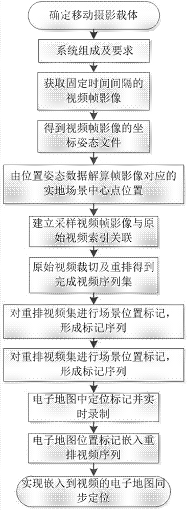
[0017] Such as figure 1 As shown, a method for synchronously displaying a moving video track in an electronic map with video playback is characterized by including the following steps: S1: Record GPS moving track, lens posture data and video results in a mobile shooting procedure; S2: Follow GPS sampling interval, get sampled video frames at fixed time intervals; S3: Obtain the synchronized video frame coordinates including GPS data and IMU (Airborne Inertial Measurement Unit) data from the playback data of GPS and IMU (Airborne Inertial Measurement Unit) equipment File; S4: Calculate the real position coordinates of the center of the sampled video frame image according to the video frame coordinate file; S5: Index the center point position of the sampled video frame image obtained by the solution to the original video frame sequence; S6: Relate the original video sequence Perform video cropping and rearrangement to obtain a multi-scene rearranged playback video sequence, and m...


PUM


Abstract

The invention discloses a moving video track and video playback synchronization displaying method in an electronic map. When a video content is photographed, GPS moving track information including coordinate and elevation data and the posture data of an IMU (inertial measurement unit) which is rigidly and fixedly connected with an aerial photo camera at a certain sampling frequency are acquired. Solving GPS data and IMU (inertial measurement unit) data are jointed to determine the field position coordinates of an image center. The index relationship between a position sequence and a video frame sequence is established, and the index relationship is used to determine the mapping between an edited video and the position information to acquire a position marker sequence. According to the position marker sequence, the marker video of a video scene moving track is recorded and displayed, and the marker video is embedded into a playback video for synchronization playback. When the video content is played, the moving video track is displayed on the electronic map.

Description

Technical field [0001] The invention relates to a track display method, in particular to a method for synchronously displaying a moving video track on an electronic map and video playback. Background technique [0002] At present, there are more and more video shooting applications based on mobile media, such as satellite shooting, drone aerial photography, and driving record. Among them, drone aerial photography and driving record are used in an increasingly wide range. This kind of shooting method, especially the video results of drone aerial photography, usually rely on human eyes to identify specific locations. This is because the video results obtained by drone aerial photography have the characteristics of multiple shooting points, large span, wide coverage, rapid changes in shooting scenes and moving paths, and a long distance between the lens and the ground. GPS positioning can only solve the positioning of the carrier and lens. Therefore, video results shot by mobile ca...

Claims


Application Information

Patent Timeline
IPC IPC(8): H04N5/445H04N7/18
CPCH04N5/445H04N7/18
Inventor 赵海强刘锋林旭芳
Owner 广州市增城区城乡规划与测绘地理信息研究院
Why Eureka
Try Eureka