Journey path planning method, device and electronic device

A technology of stroke planning and path planning, which is applied in the direction of measuring devices, road network navigators, instruments, etc., can solve the problems that the navigation map is not updated in time, cannot make detour navigation, etc., and achieve the effect of improving operation efficiency

Inactive Publication Date: 2017-08-04
UISEE SHANGHAI AUTOMOTIVE TECH LTD
View PDF7 Cites 18 Cited by
  • Summary
  • Abstract
  • Description
  • Claims
  • Application Information

AI Technical Summary

Problems solved by technology

[0004] (2) When entering a destination search, other destinations with the same name may be found;
[0006] In the event of temporary road maintenance / or traffic accidents, etc., and the navigation map is not updated in time, the system will still navigate according to the original set route and cannot perform detour navigation

Method used


Image

  • Journey path planning method, device and electronic device
  • Journey path planning method, device and electronic device
  • Journey path planning method, device and electronic device

Examples


Embodiment 1

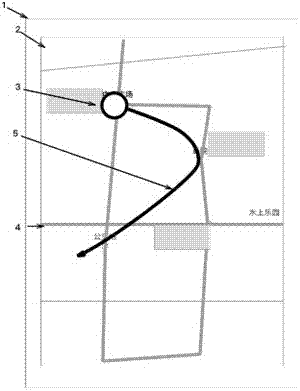
[0095] like figure 1 As shown, the electronic ground is displayed on the display screen 2 of the navigation device 1 Figure 4 , electronically Figure 4 There are a large number of discrete keypoints. These key points are information points secondary processed by the electronic map data provider or specific location points of the electronic map itself, such as crossroads, roads, or locations of shopping malls, hospitals, stations, etc. or POI (Point of Interest). The present invention uses the POI point as an example to illustrate the present invention, but is not limited to the POI point.

[0096] The user can slide the finger, touch pen or mouse to indicate the electronic location displayed on the display screen 2. Figure 4 Form a track representation on the screen, for example, the display screen 2 can be a touch screen, and the user touches the display screen 2 with a finger or a touch pen, and the electronic ground displayed on the display screen 2 Figure 4 Swipe u...

Embodiment 2

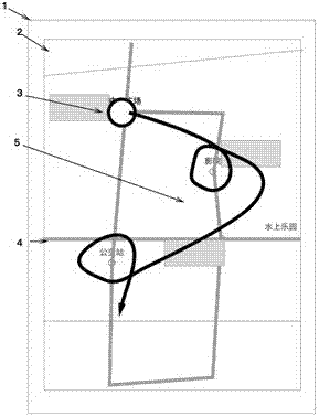
[0105] In one embodiment of the present invention, usually, the user forms a track representation in the electronic map with continuous gesture input. In order to distinguish the key points from the common track in the continuous input, a specific operations to identify the key points of the itinerary.

[0106] Optionally, the nearest information point within a certain range from the trajectory representation is automatically selected as the key point of the itinerary. Typically, when the user's gestures slide continuously indiscriminately, it is automatically judged whether there is an information point within a certain range of the gesture track, and if there is, the information point closest to the gesture track is automatically selected as the key point of the journey here. In this way, the user only needs to swipe the contact and ensure that the gesture trajectory is as close as possible to the desired POI point (in order to avoid misuse, it may also need to be as far awa...

Embodiment 3

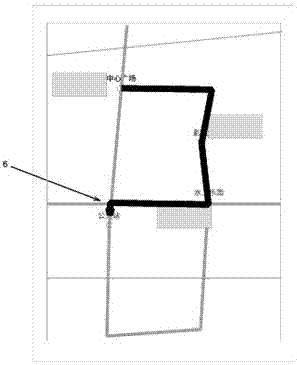
[0131] On the basis of Embodiments 1 and 2, the user can select meaningful POI points in a delineated manner. In order to specify POI points more clearly, some users are accustomed to delineating a certain POI point from multiple POI points as a meaningful POI point by drawing a circle.

[0132] When the user's finger slides on the display screen 2 of the navigation device 1 to form a trajectory, a closed circle can be formed around a certain POI point. like image 3 As shown in , the user forms a closed circle around two POIs, the theater and the bus station. When the navigation device 1 detects that a circle appears around the POI points of the trajectory, these two POI points are regarded as meaningful POI points, not as the trajectory.


PUM


Abstract

The invention relates to a journey path planning method, a device and an electronic device. The method comprises the following steps: receiving continuous input of a user; identifying the track representation of the continuous input in an electronic map; and generating a journey planning path according to the serial connection sequence of journey key points of the track representation. According to the journey path planning method, device, electronic device or computer programming products, the problem that the journey can be planned manually without manually inputting a starting point, intermediate stops and a destination point can be solved. According to the scheme, the journey path including multiple intermediate targets can be automatically planned according to requirement, so that the accuracy, convenience and reliability of operation efficiency and navigation can be greatly improved.

Description

technical field [0001] The invention belongs to the technical field of electronic maps, and in particular relates to a travel path planning method, device and electronic equipment. Background technique [0002] Currently setting the itinerary is a common operation in navigation software, driverless driving, and car-hailing software. During the itinerary setting process, two steps are usually required: determining the starting point and selecting the destination. These software take the current location as the starting point, and only need to select the destination to plan the navigation path, and some software can set multiple passing destinations. But there is following problem in the method for these itinerary setting: [0003] (1) The map point selection method is easy to select open spaces, rivers, etc. that vehicles cannot reach; [0004] (2) When entering a destination search, other destinations with the same name may be found; [0005] (3) When selecting multiple ...

Claims


Application Information

Patent Timeline
Patent Type & Authority Applications(China)
IPC IPC(8): G01C21/34G01C21/36
CPCG01C21/3476G01C21/3614
Inventor 周峰
Owner UISEE SHANGHAI AUTOMOTIVE TECH LTD
Why Eureka
Try Eureka