Joint calibration method for satellite-borne optical camera-laser range finder combined system

A technology of laser range finder and optical camera, which is applied in the direction of instruments, measuring devices, etc., can solve the problems that the system error cannot be eliminated, the positioning accuracy cannot be improved, and the advantages of system combination positioning cannot be reflected.

Active Publication Date: 2017-08-04
自然资源部国土卫星遥感应用中心
View PDF3 Cites 19 Cited by
  • Summary
  • Abstract
  • Description
  • Claims
  • Application Information

AI Technical Summary

Problems solved by technology

However, the distance observation equation has nothing to do with the camera's outer azimuth angle element, and the data correlation between the optical camera and the laser rangefinder is weak, and there are certain deficiencies
[0007] In particular, it should be noted that if the system error within the combined system ca...

Method used


Image

  • Joint calibration method for satellite-borne optical camera-laser range finder combined system
  • Joint calibration method for satellite-borne optical camera-laser range finder combined system
  • Joint calibration method for satellite-borne optical camera-laser range finder combined system

Examples


Embodiment Construction

[0070] The present invention is described more fully hereinafter, in which exemplary embodiments of the invention are illustrated.

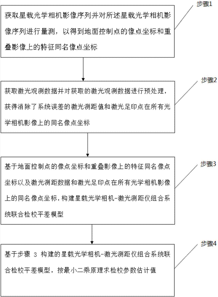
[0071] The space-borne optical camera-laser range finder combination system joint inspection and adjustment method proposed by the present invention specifically includes the following steps:

[0072] Step 1, obtaining the image sequence of the spaceborne optical camera and measuring the image sequence of the spaceborne optical camera to obtain the image point coordinates of the ground control point and the image point coordinates of the feature with the same name on the overlapping image;

[0073] Step 1 specifically includes the following sub-steps:

[0074] Step 1.1, start the space-borne optical camera, image the ground at different positions during the satellite orbit, and obtain multi-view ground surface images (that is, the space-borne optical camera image sequence), wherein the space-borne optical camera image sequence It is a sequence o...


PUM


Abstract

The invention discloses a joint calibration and adjustment method for a satellite-borne optical camera-laser range finder combined system. According to the method, geometric correlation between a satellite-borne optical camera and a satellite-borne laser range finder is built by using a geometrical relationship of an internal structure of the satellite-borne optical camera-laser range finder combined system, a joint calibration and adjustment model based on an optical stereoscopic image observation equation and a laser ranging observation equation is built, high-precision estimation of orientation elements in the optical camera an relative orientation elements between the laser range finder and the optical camera can be achieved at the same time, and the influence of a system error is automatically compensated, thereby fully developing the advantages of the combined system in three-dimensional positioning of a ground target.

Description

technical field [0001] The invention relates to the technical field of geometric processing of optical surveying and mapping satellite data, in particular to a joint calibration method of a spaceborne optical camera-laser rangefinder combination system, which is applied to on-orbit geometric calibration and ground target positioning of a satellite photogrammetry system. Background technique [0002] In recent years, my country's satellite remote sensing surveying and mapping technology capabilities have developed rapidly, but there is still a gap compared with the international advanced level. On the basis of the current domestic satellite payload development capabilities, by designing a combined system of different functional payloads, using data post-processing technology to extract high-precision target geographic information, it can reduce the difficulty of hardware development, shorten the development cycle, and meet the application requirements. It is a feasible way to...

Claims


Application Information

Patent Timeline
IPC IPC(8): G01C25/00
CPCG01C25/00
Inventor 谢俊峰唐新明余俊鹏殷宝库范大昭余凡祝小勇王甄铭赵利平
Owner 自然资源部国土卫星遥感应用中心
Why Eureka
Try Eureka