
Reservoir area high slope unmanned aerial vehicle automatic monitoring system and method

An automatic monitoring system and unmanned aerial vehicle technology, applied in signal transmission systems, closed-circuit television systems, wireless communications, etc., can solve the problems of no monitoring system, high monitoring cost, and inconvenient transportation, so as to improve monitoring efficiency and reduce monitoring cost effect

Pending Publication Date: 2017-08-22
NANJING HYDRAULIC RES INST
View PDF7 Cites 12 Cited by
  • Summary
  • Abstract
  • Description
  • Claims
  • Application Information

AI Technical Summary

Problems solved by technology

[0003] Existing landslide monitoring and monitoring technologies mostly focus on a certain or partial landslide; for the monitoring and monitoring and early warning of a large number of landslides, due to the wide range of landslides, inconvenient transportation, high monitoring costs, and difficult analysis, there is currently no An integrated and efficient monitoring system appears to realize batch monitoring of a large number of high slopes

Method used


Image

  • Reservoir area high slope unmanned aerial vehicle automatic monitoring system and method
  • Reservoir area high slope unmanned aerial vehicle automatic monitoring system and method
  • Reservoir area high slope unmanned aerial vehicle automatic monitoring system and method

Examples


Embodiment Construction

[0019] The principles and features of the present invention will be further described below in conjunction with the accompanying drawings.

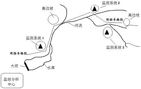
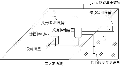
[0020] As shown in the figure, the invention monitors the high slopes on both sides of the river upstream of a certain reservoir, and a total of 5 high slopes are selected on both sides of the river for inspection, monitoring and monitoring; according to the project requirements and objectives, 3 of them are The high slope (marked with a black triangle) has a monitoring system installed, and UAV photography and monitoring data collection are carried out at the same time; the other two high slopes are photographed by UAV without monitoring.

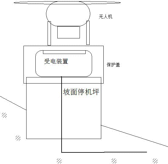
[0021] Among them, monitoring system 1 and monitoring system 2 are located on the south bank of the high slope of the mountain, with sufficient sunlight; monitoring system 3 is located on the north bank of the mountain, with less sunlight. In order to avoid the insufficient power supply of the solar p...


PUM


Abstract

The invention discloses a reservoir area high slope unmanned aerial vehicle automatic monitoring system and method. The system comprises monitoring systems, a solar current collection apparatus, an unmanned aerial vehicle, an unmanned aerial vehicle mobile station, an inspection vehicle and a monitoring analysis center, the monitoring systems are arranged on high slopes and acquire monitoring data of the high slopes, the monitoring systems perform data transmission with the monitoring analysis center through a mobile network in high slope regions covered by the mobile network and perform short-distance data transmission through bluetooth and the unmanned aerial vehicle in high slope regions which are not covered by the mobile network, the unmanned aerial vehicle is connected with the monitoring analysis center through the mobile network to realize data transmission when flying into a mobile network covering region, the unmanned aerial vehicle mobile station is arranged on the inspection vehicle, provided with a fuel generator, and used for maintenance and charging of the unmanned aerial vehicle, and the monitoring systems can obtain electric energy through the solar current collection apparatus or the unmanned aerial vehicle. According to the system and method, rapid and automatic monitoring of a lot of high slopes of a reservoir area can be realized, assistance is provided for the security of the high slopes of the reservoir area, and the security of a reservoir dam and the high slopes of the reservoir area can be guaranteed.

Description

technical field [0001] The invention relates to the monitoring and monitoring field of high side slopes, in particular to the batch monitoring and monitoring of a large number of high side slopes under the complex environment of reservoir areas. Background technique [0002] So far, landslide disasters have occurred almost everywhere in the mountainous areas where human beings live and engineering activities, and landslides have become the most frequent and costly types of geological disasters among various disasters. A large number of reservoirs are built in high mountains and canyons, and there are often a large number of high slopes distributed on both sides of the reservoir area. Reservoir area landslides are typical landslides caused by human engineering activities. These high slopes are not only affected by rainfall and geology, but also affected by reservoir basin deformation and water level fluctuations. Due to the wide range of high slopes in the reservoir area and...

Claims


Application Information

Patent Timeline
Patent Type & Authority Applications(China)
IPC IPC(8): H04N7/18H04W4/00G08C17/02G01D21/02H02J7/35H02J50/00H02J7/00
CPCH02J5/005H02J7/025H02J7/35H04N7/18G08C17/02G01D21/02
Inventor 杨阳范光亚何勇军徐海峰李宏恩李卓李铮尹志灏朱沁夏
Owner NANJING HYDRAULIC RES INST
Learn More